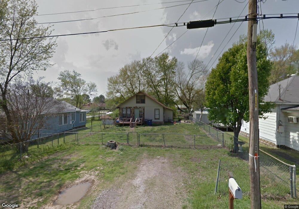
4812 S 27th St Fort Smith, AR 72901
South Fort Smith NeighborhoodEstimated Value: $83,675 - $117,000
--
Bed
1
Bath
960
Sq Ft
$110/Sq Ft
Est. Value
About This Home
This home is located at 4812 S 27th St, Fort Smith, AR 72901 and is currently estimated at $105,919, approximately $110 per square foot. 4812 S 27th St is a home located in Sebastian County with nearby schools including Carnall Elementary School, Ramsey Junior High School, and Southside High School.
Ownership History
Date
Name
Owned For
Owner Type
Purchase Details
Closed on
May 18, 1995
Bought by
Tucker Lowell M and Tucker Loc T
Current Estimated Value
Purchase Details
Closed on
Feb 24, 1995
Bought by
Secretary Of Housing & Urban D
Purchase Details
Closed on
Dec 12, 1994
Bought by
Pnc Bank Kentucky Inc
Purchase Details
Closed on
Apr 14, 1993
Bought by
English Donna Sue
Purchase Details
Closed on
Mar 28, 1990
Bought by
Martin H Buel
Purchase Details
Closed on
Oct 23, 1986
Bought by
Folk Joe L and Folk Lois
Create a Home Valuation Report for This Property
The Home Valuation Report is an in-depth analysis detailing your home's value as well as a comparison with similar homes in the area
Home Values in the Area
Average Home Value in this Area
Purchase History
| Date | Buyer | Sale Price | Title Company |
|---|---|---|---|
| Tucker Lowell M | -- | -- | |
| Secretary Of Housing & Urban D | -- | -- | |
| Pnc Bank Kentucky Inc | -- | -- | |
| English Donna Sue | $31,000 | -- | |
| Martin H Buel | $29,000 | -- | |
| Folk Joe L | $33,000 | -- | |
| Martin H Buel | -- | -- | |
| Sanders Roney Joe | -- | -- |
Source: Public Records
Tax History Compared to Growth
Tax History
| Year | Tax Paid | Tax Assessment Tax Assessment Total Assessment is a certain percentage of the fair market value that is determined by local assessors to be the total taxable value of land and additions on the property. | Land | Improvement |
|---|---|---|---|---|
| 2024 | $470 | $8,960 | $1,800 | $7,160 |
| 2023 | $520 | $8,960 | $1,800 | $7,160 |
| 2022 | $520 | $8,960 | $1,800 | $7,160 |
| 2021 | $520 | $8,960 | $1,800 | $7,160 |
| 2020 | $490 | $8,960 | $1,800 | $7,160 |
| 2019 | $445 | $7,670 | $1,800 | $5,870 |
| 2018 | $445 | $7,670 | $1,800 | $5,870 |
| 2017 | $403 | $7,670 | $1,800 | $5,870 |
| 2016 | $384 | $7,670 | $1,800 | $5,870 |
| 2015 | $384 | $7,670 | $1,800 | $5,870 |
| 2014 | $349 | $6,650 | $1,200 | $5,450 |
Source: Public Records
Map
Nearby Homes
- 4810 S 27th St
- 2923 S Quincy St
- 4610 S 26th St
- 2411 Raleigh St
- 5017 S 28th St
- 4615 S 30th St
- 6 Raleigh Cir
- 2308 Savannah St
- 2307 Osage Cir
- 4308 S 25th St
- 2916 Cliff Dr
- 5114 S 32nd St
- 4721 Jenny Lind Rd
- 4209 Old Jenny Lind Rd
- 3917 S 27th Cir
- 3319 Southview Dr
- 1923 Waco St
- 4110 S 34th St
- 3231 Cliff Dr
- 1712 Memphis St