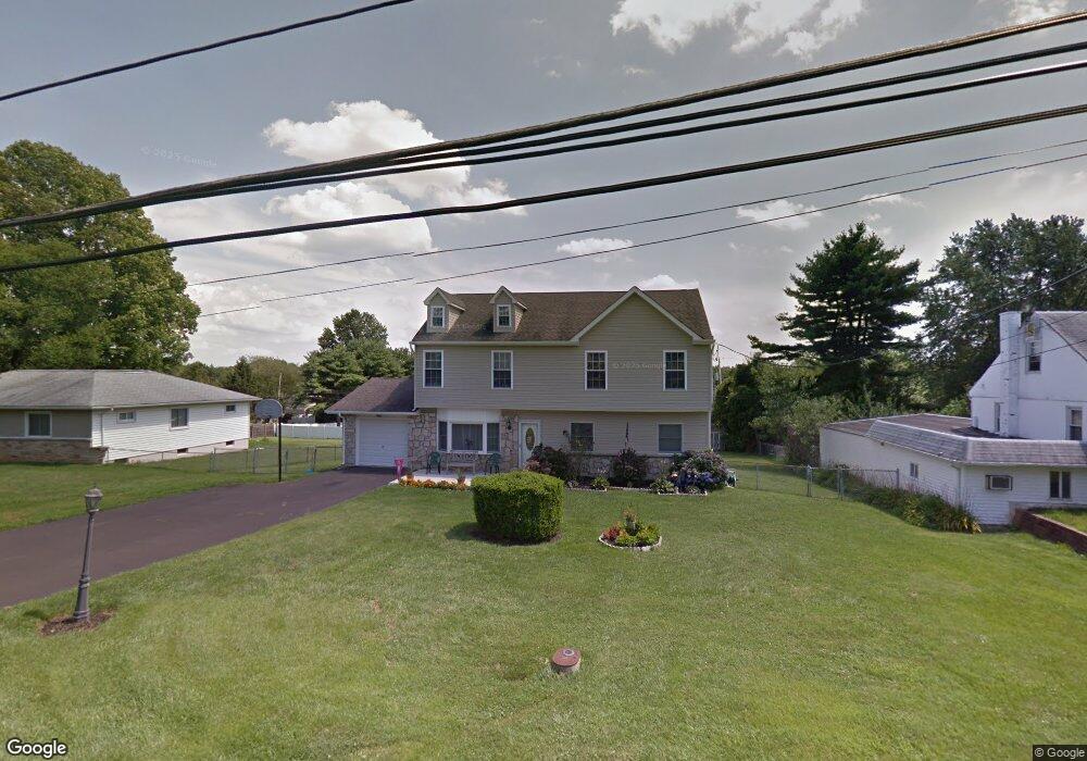
4823 Hillside Ave Bensalem, PA 19020
Neshaminy Valley NeighborhoodEstimated Value: $493,000 - $563,551
4
Beds
2
Baths
2,394
Sq Ft
$226/Sq Ft
Est. Value
About This Home
This home is located at 4823 Hillside Ave, Bensalem, PA 19020 and is currently estimated at $539,888, approximately $225 per square foot. 4823 Hillside Ave is a home located in Bucks County with nearby schools including Belmont Hills El School, Robert K. Shafer Middle School, and Bensalem Baptist School.
Ownership History
Date
Name
Owned For
Owner Type
Purchase Details
Closed on
Sep 15, 1995
Sold by
Mckenna James J and Brown Teresa M
Bought by
Simcox Timothy and Simcox Tracey
Current Estimated Value
Home Financials for this Owner
Home Financials are based on the most recent Mortgage that was taken out on this home.
Original Mortgage
$130,500
Interest Rate
7.81%
Purchase Details
Closed on
Feb 11, 1982
Bought by
Brown Russell E and Brown Teresa M
Create a Home Valuation Report for This Property
The Home Valuation Report is an in-depth analysis detailing your home's value as well as a comparison with similar homes in the area
Home Values in the Area
Average Home Value in this Area
Purchase History
| Date | Buyer | Sale Price | Title Company |
|---|---|---|---|
| Simcox Timothy | $137,400 | Lawyers Title Insurance Corp | |
| Brown Russell E | -- | -- |
Source: Public Records
Mortgage History
| Date | Status | Borrower | Loan Amount |
|---|---|---|---|
| Closed | Simcox Timothy | $130,500 |
Source: Public Records
Tax History Compared to Growth
Tax History
| Year | Tax Paid | Tax Assessment Tax Assessment Total Assessment is a certain percentage of the fair market value that is determined by local assessors to be the total taxable value of land and additions on the property. | Land | Improvement |
|---|---|---|---|---|
| 2025 | $6,994 | $32,040 | $5,560 | $26,480 |
| 2024 | $6,994 | $32,040 | $5,560 | $26,480 |
| 2023 | $6,797 | $32,040 | $5,560 | $26,480 |
| 2022 | $6,757 | $32,040 | $5,560 | $26,480 |
| 2021 | $6,757 | $32,040 | $5,560 | $26,480 |
| 2020 | $6,689 | $32,040 | $5,560 | $26,480 |
| 2019 | $6,540 | $32,040 | $5,560 | $26,480 |
| 2018 | $6,389 | $32,040 | $5,560 | $26,480 |
| 2017 | $6,348 | $32,040 | $5,560 | $26,480 |
| 2016 | $6,348 | $32,040 | $5,560 | $26,480 |
| 2015 | -- | $32,040 | $5,560 | $26,480 |
| 2014 | -- | $32,040 | $5,560 | $26,480 |
Source: Public Records
Map
Nearby Homes
- 3021 Claridge Rd
- 3011 Claridge Rd
- 4828 Oxford Ct
- 5178 Neshaminy Blvd
- 3162 Sheppard Rd
- 3782 Grandview Ave
- 4902 Oxford Ct
- 4912 Oxford Ct Unit 2
- 3191 Drexel Rd
- 225 Saddlebrook Dr
- 223 Saddlebrook Dr
- 4525 Winding Brook Dr Unit 4525
- 6561 Neshaminy Valley Dr
- 6257 Nathan Hale Ct
- 400 Brister Rd
- 6369 Powder Horn Ct
- 413 Brister Rd
- 2493 Barnsleigh Dr
- 120 Liberty Dr Unit 120
- 2548 Nashua Rd
- 4908 Hillside Ave
- 4811 Hillside Ave
- 4860 Sunrise Ave
- 4922 Hillside Ave
- 4759 Hillside Ave
- 4878 Sunrise Ave
- 4852 Sunrise Ave
- 4830 Hillside Ave
- 4752 Hillside Ave
- 4820 Hillside Ave
- 4836 Sunrise Ave
- 4840 Hillside Ave
- 4748 Hillside Ave
- 4890 Sunrise Ave
- 4743 Hillside Ave
- 3 New Rd
- 3 New Rd
- 3 New Rd
- 4909 Hillside Ave
- 4824 Sunrise Ave