Estimated Value: $249,000 - $306,000
3
Beds
2
Baths
1,196
Sq Ft
$230/Sq Ft
Est. Value
About This Home
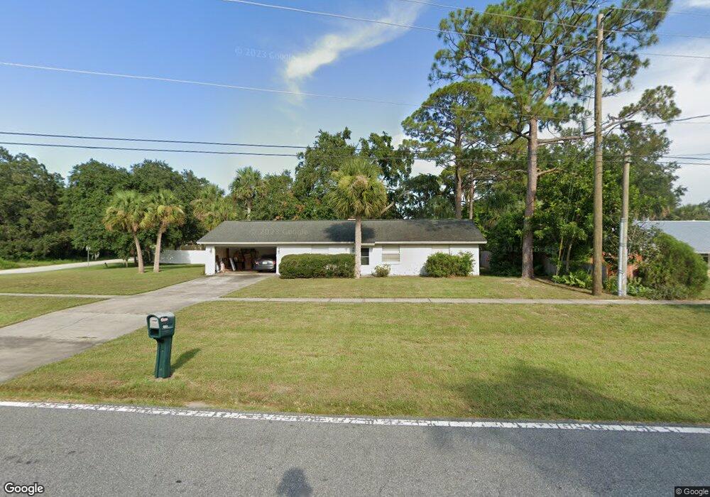
This home is located at 4825 Curtis Blvd, Cocoa, FL 32927 and is currently estimated at $274,496, approximately $229 per square foot. 4825 Curtis Blvd is a home located in Brevard County with nearby schools including Atlantis Elementary School, Space Coast Junior/Senior High School, and Sculptor Charter School.
Ownership History
Date
Name
Owned For
Owner Type
Purchase Details
Closed on
Oct 5, 1994
Sold by
Floyd Greg H and Floyd Pamela D
Bought by
Floyd Greg H
Current Estimated Value
Purchase Details
Closed on
Jan 31, 1994
Sold by
Dixon Lois D and Dixon Leslie Lois
Bought by
Floyd Greg H and Floyd Pamela D
Home Financials for this Owner
Home Financials are based on the most recent Mortgage that was taken out on this home.
Original Mortgage
$64,260
Interest Rate
7.1%
Create a Home Valuation Report for This Property
The Home Valuation Report is an in-depth analysis detailing your home's value as well as a comparison with similar homes in the area
Home Values in the Area
Average Home Value in this Area
Purchase History
| Date | Buyer | Sale Price | Title Company |
|---|---|---|---|
| Floyd Greg H | $31,900 | -- | |
| Floyd Greg H | $63,000 | -- |
Source: Public Records
Mortgage History
| Date | Status | Borrower | Loan Amount |
|---|---|---|---|
| Previous Owner | Floyd Greg H | $64,260 |
Source: Public Records
Tax History
| Year | Tax Paid | Tax Assessment Tax Assessment Total Assessment is a certain percentage of the fair market value that is determined by local assessors to be the total taxable value of land and additions on the property. | Land | Improvement |
|---|---|---|---|---|
| 2025 | $1,024 | $74,630 | -- | -- |
| 2024 | $1,004 | $72,530 | -- | -- |
| 2023 | $1,004 | $70,420 | $0 | $0 |
| 2022 | $948 | $68,370 | $0 | $0 |
| 2021 | $950 | $66,380 | $0 | $0 |
| 2020 | $905 | $65,470 | $0 | $0 |
| 2019 | $852 | $64,000 | $0 | $0 |
| 2018 | $853 | $62,810 | $0 | $0 |
| 2017 | $854 | $61,520 | $0 | $0 |
| 2016 | $861 | $60,260 | $18,000 | $42,260 |
| 2015 | $867 | $59,850 | $15,000 | $44,850 |
| 2014 | $872 | $59,380 | $11,000 | $48,380 |
Source: Public Records
Map
Nearby Homes
- 4824 Curtis Blvd
- 4760 Ivan St
- 6990 Camden Ave
- 6820 Caliph Ave
- 7045 Grissom Pkwy
- 4790 Greenhill St
- 4625 Curtis Blvd
- 4852 Alfred St
- 5075 Carter St
- 7155 Export Ave
- 5080 Mayflower St
- 0000 Unknown St
- 6620 Grissom Pkwy
- 7245 Grissom Pkwy
- 6947 Carlowe Ave
- 5200 Frisco St
- 5095 Hogan Place
- 5155 Mayflower St
- 4688 Fairsun St
- 7160 Carlowe Ave
- 4835 Curtis Blvd
- 6796 Opal Ave
- 4845 Curtis Blvd
- 4815 Fresno St
- 6888 Dodge Rd
- 4800 Fresno St
- 4720 Fresno St
- 6778 Opal Ave
- 4825 Fresno St
- 0000 Fresno St
- 6797 Opal Ave
- 3840 Curtis Blvd
- 5545 Curtis Blvd
- 4810 Fresno St
- 6880 Dodge Rd
- 6785 Opal Ave
- 4865 Curtis Blvd
- 4835 Fresno St
- 6772 Opal Ave
- 6779 Opal Ave
Your Personal Tour Guide
Ask me questions while you tour the home.