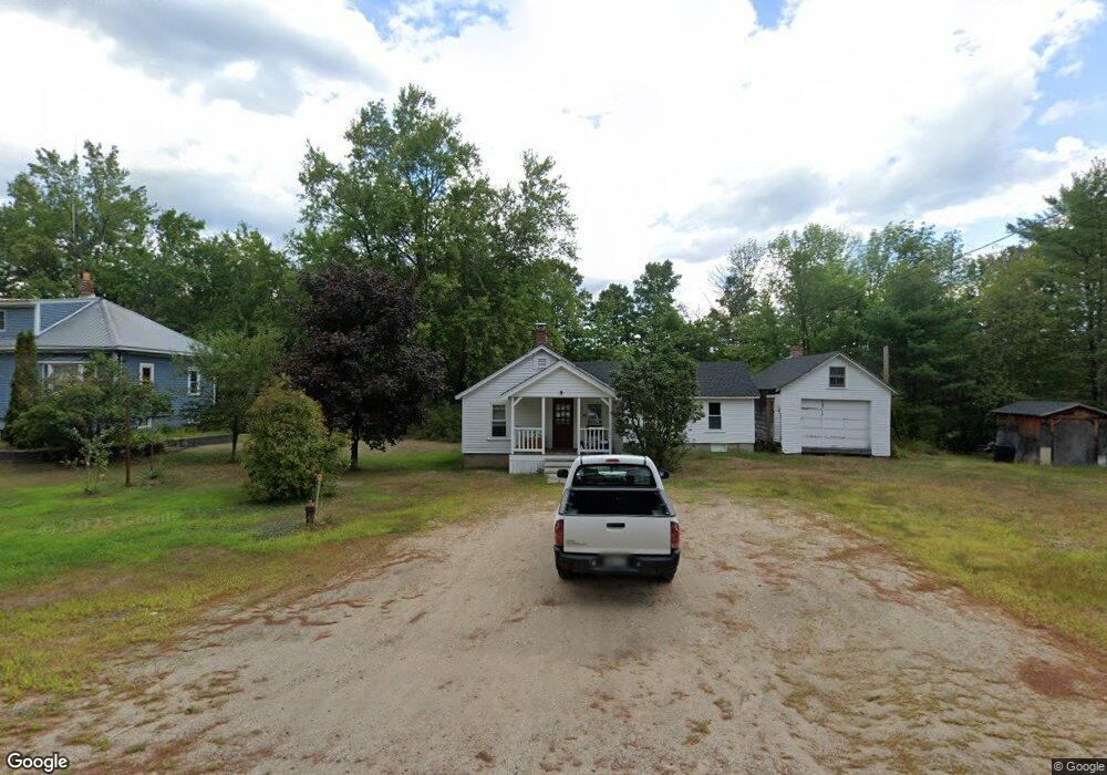
483 Whittier Rd West Ossipee, NH 03890
Estimated Value: $249,000 - $284,000
1
Bed
1
Bath
957
Sq Ft
$280/Sq Ft
Est. Value
About This Home
This home is located at 483 Whittier Rd, West Ossipee, NH 03890 and is currently estimated at $268,229, approximately $280 per square foot. 483 Whittier Rd is a home located in Carroll County with nearby schools including Kenneth A. Brett School, Bear Camp Valley School, and The Community School.
Ownership History
Date
Name
Owned For
Owner Type
Purchase Details
Closed on
Jul 23, 2004
Sold by
Stone Irene L Est
Bought by
Crowell Ronald R
Current Estimated Value
Home Financials for this Owner
Home Financials are based on the most recent Mortgage that was taken out on this home.
Original Mortgage
$40,000
Outstanding Balance
$20,899
Interest Rate
6.28%
Mortgage Type
Purchase Money Mortgage
Estimated Equity
$261,381
Create a Home Valuation Report for This Property
The Home Valuation Report is an in-depth analysis detailing your home's value as well as a comparison with similar homes in the area
Home Values in the Area
Average Home Value in this Area
Purchase History
| Date | Buyer | Sale Price | Title Company |
|---|---|---|---|
| Crowell Ronald R | $40,000 | -- |
Source: Public Records
Mortgage History
| Date | Status | Borrower | Loan Amount |
|---|---|---|---|
| Open | Crowell Ronald R | $40,000 |
Source: Public Records
Tax History Compared to Growth
Tax History
| Year | Tax Paid | Tax Assessment Tax Assessment Total Assessment is a certain percentage of the fair market value that is determined by local assessors to be the total taxable value of land and additions on the property. | Land | Improvement |
|---|---|---|---|---|
| 2024 | $3,062 | $212,200 | $69,100 | $143,100 |
| 2023 | $2,811 | $111,400 | $37,600 | $73,800 |
| 2022 | $2,648 | $111,400 | $37,600 | $73,800 |
| 2021 | $2,575 | $116,300 | $37,600 | $78,700 |
| 2020 | $2,614 | $116,300 | $37,600 | $78,700 |
| 2019 | $2,505 | $116,300 | $37,600 | $78,700 |
| 2018 | $1,958 | $84,900 | $19,800 | $65,100 |
| 2017 | $1,927 | $84,900 | $19,800 | $65,100 |
| 2016 | $1,948 | $84,900 | $19,800 | $65,100 |
| 2015 | $1,940 | $84,900 | $19,800 | $65,100 |
| 2013 | $1,794 | $89,700 | $22,900 | $66,800 |
Source: Public Records
Map
Nearby Homes
- 23 Summit View Dr
- 255 Summit View Dr
- 756 Whittier Rd
- 190 Whittier Rd
- Map 206 Lot 28 Whittier Rd
- 498 Whittier Rd
- 137 Durrell Rd
- 86 Bearcamp Hwy
- 527 Tamworth Rd
- 27 Butternut Ln
- 71 May's Way
- 515 Hollow Hill Rd
- 495 Durell Rd
- 83 Tamworth Rd
- 55 Hollow Hill Rd
- 400 Turkey St
- 48 South Way
- 13 Mill Rd
- 1785 White Mountain Hwy
- 58 Thibodeau Ln
- 486 Whittier
- 475 Whittier Rd
- 486 Whittier Rd
- 478 Whittier Rd
- 514 Whittier Rd
- 249 Bryant Rd
- 231 Bryant Rd
- 556 Whittier Rd
- 577 Whittier Rd
- 578 Whittier Rd
- 379 Whittier Rd
- 372 Whittier Rd
- 600 Whittier Rd
- 139 Bryant Rd
- off Bryant Rd Unit 415-81
- 339 Whittier Rd
- 339 Whittier Rd
- 19 Mabel Evans Rd
- 645 Whittier Rd
- 25 Whittier Rd