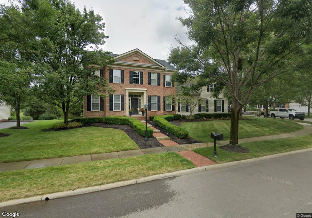
4848 Brooksview Cir New Albany, OH 43054
Estimated Value: $820,322 - $1,141,000
4
Beds
4
Baths
3,443
Sq Ft
$276/Sq Ft
Est. Value
About This Home
This home is located at 4848 Brooksview Cir, New Albany, OH 43054 and is currently estimated at $949,581, approximately $275 per square foot. 4848 Brooksview Cir is a home located in Franklin County with nearby schools including New Albany Primary School, New Albany Intermediate School, and New Albany Middle School.
Ownership History
Date
Name
Owned For
Owner Type
Purchase Details
Closed on
Aug 27, 2014
Sold by
Vinciguerra Joseph C and Vinciguerra Kathy D
Bought by
Freedman Matthew J and Freedman Lisa S
Current Estimated Value
Home Financials for this Owner
Home Financials are based on the most recent Mortgage that was taken out on this home.
Original Mortgage
$242,000
Outstanding Balance
$184,993
Interest Rate
4.1%
Mortgage Type
New Conventional
Estimated Equity
$764,588
Purchase Details
Closed on
Aug 28, 2003
Sold by
M/I Schottenstein Homes Inc
Bought by
Vinciguerra Joseph C and Vinciguerra Kathy D
Create a Home Valuation Report for This Property
The Home Valuation Report is an in-depth analysis detailing your home's value as well as a comparison with similar homes in the area
Home Values in the Area
Average Home Value in this Area
Purchase History
| Date | Buyer | Sale Price | Title Company |
|---|---|---|---|
| Freedman Matthew J | $495,000 | Fatco | |
| Vinciguerra Joseph C | $500,600 | -- |
Source: Public Records
Mortgage History
| Date | Status | Borrower | Loan Amount |
|---|---|---|---|
| Open | Freedman Matthew J | $242,000 |
Source: Public Records
Tax History Compared to Growth
Tax History
| Year | Tax Paid | Tax Assessment Tax Assessment Total Assessment is a certain percentage of the fair market value that is determined by local assessors to be the total taxable value of land and additions on the property. | Land | Improvement |
|---|---|---|---|---|
| 2024 | $15,195 | $244,240 | $44,630 | $199,610 |
| 2023 | $14,436 | $244,230 | $44,625 | $199,605 |
| 2022 | $16,509 | $213,330 | $33,600 | $179,730 |
| 2021 | $15,888 | $213,330 | $33,600 | $179,730 |
| 2020 | $15,782 | $213,330 | $33,600 | $179,730 |
| 2019 | $14,383 | $176,790 | $28,000 | $148,790 |
| 2018 | $13,845 | $176,930 | $28,000 | $148,930 |
| 2017 | $14,370 | $176,930 | $28,000 | $148,930 |
| 2016 | $13,442 | $152,290 | $37,170 | $115,120 |
| 2015 | $13,468 | $152,290 | $37,170 | $115,120 |
| 2014 | $12,987 | $152,290 | $37,170 | $115,120 |
| 2013 | $6,673 | $145,005 | $35,385 | $109,620 |
Source: Public Records
Map
Nearby Homes
- 7362 Tottenham Place
- 6929 Clivdon Mews
- 5945 Johnstown Rd
- 109 Keswick Dr
- 115 Keswick Dr
- 105 Keswick Dr
- 4774 Bosk Dr
- 6813 Ridge Rock Dr Unit 14
- 5950 Johnstown Rd
- 7 Richmond Square
- 4135 High Grove Crest
- 14 Richmond Square
- 5556 Falco Dr
- 7030 Hanby's Loop
- 6923 Rothwell St Unit 46923
- 6931 Rothwell St Unit 36931
- 6439 Lake Mathias Dr
- 5288 Abby Gate Ave Unit 16
- 5600 Apothecary Way
- 5604 Apothecary Way Unit 4
- 4830 Brooksview Cir
- 4875 Brooksview Cir
- 4864 Brooksview Cir
- 4854 Brooksview Cir
- 4874 Brooksview Cir
- 5010 Brooksview Cir
- 5010 Brooksview Cir Unit R
- 4992 Brooksview Cir
- 4921 Brooksview Cir
- 4931 Brooksview Cir
- 4884 Brooksview Cir
- 4941 Brooksview Cir
- 4951 Brooksview Cir
- 4894 Brooksview Cir
- 5005 Brooksview Cir
- 4995 Brooksview Cir
- 5015 Brooksview Cir
- 4930 Brooksview Cir
- 4985 Brooksview Cir
- 4918 Brooksview Cir