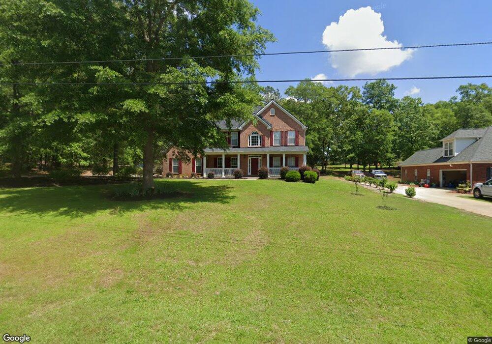
485 Saint Andrews Dr Jackson, GA 30233
Estimated Value: $405,621 - $481,000
Studio
4
Baths
2,669
Sq Ft
$160/Sq Ft
Est. Value
About This Home
This home is located at 485 Saint Andrews Dr, Jackson, GA 30233 and is currently estimated at $427,905, approximately $160 per square foot. 485 Saint Andrews Dr is a home located in Butts County with nearby schools including Jackson High School.
Ownership History
Date
Name
Owned For
Owner Type
Purchase Details
Closed on
May 25, 2018
Sold by
Smith Rhonda T
Bought by
Nelson William D and Nelson Julie B
Current Estimated Value
Home Financials for this Owner
Home Financials are based on the most recent Mortgage that was taken out on this home.
Original Mortgage
$230,755
Outstanding Balance
$197,872
Interest Rate
4.5%
Mortgage Type
New Conventional
Estimated Equity
$230,033
Purchase Details
Closed on
Jan 11, 2006
Sold by
Smith E Byron
Bought by
Smith Rhonda T
Create a Home Valuation Report for This Property
The Home Valuation Report is an in-depth analysis detailing your home's value as well as a comparison with similar homes in the area
Home Values in the Area
Average Home Value in this Area
Purchase History
| Date | Buyer | Sale Price | Title Company |
|---|---|---|---|
| Nelson William D | $242,900 | -- | |
| Smith Rhonda T | -- | -- |
Source: Public Records
Mortgage History
| Date | Status | Borrower | Loan Amount |
|---|---|---|---|
| Open | Nelson William D | $230,755 |
Source: Public Records
Tax History
| Year | Tax Paid | Tax Assessment Tax Assessment Total Assessment is a certain percentage of the fair market value that is determined by local assessors to be the total taxable value of land and additions on the property. | Land | Improvement |
|---|---|---|---|---|
| 2025 | $4,067 | $179,243 | $15,960 | $163,283 |
| 2024 | $4,067 | $179,243 | $15,960 | $163,283 |
| 2023 | $4,278 | $162,330 | $15,960 | $146,370 |
| 2022 | $3,572 | $133,639 | $12,000 | $121,639 |
| 2021 | $3,393 | $118,805 | $12,000 | $106,805 |
| 2020 | $3,405 | $114,879 | $12,000 | $102,879 |
| 2019 | $2,569 | $88,076 | $12,000 | $76,076 |
| 2018 | $2,423 | $81,629 | $12,000 | $69,629 |
| 2017 | $2,456 | $81,309 | $12,000 | $69,309 |
| 2016 | $2,469 | $79,709 | $10,400 | $69,309 |
| 2015 | $2,222 | $79,709 | $10,400 | $69,309 |
| 2014 | $2,168 | $68,882 | $10,400 | $58,482 |
Source: Public Records
Map
Nearby Homes
- 480 Hickory Ridge Rd
- 330 James Moore Cir
- 1375 Highway 42 S
- 14 Weaver St
- 908 Nelson St
- 124 Harper St
- 347 Ww Carr Ave
- 544 Franklin St
- 144 Blake Ave
- 321 Kirts Ridge
- 193 Brownlee Rd
- 472 Grand Magnolia St
- 474 Grand Magnolia St
- 476 Grand Magnolia St
- 478 Grand Magnolia St
- 466 Grand Magnolia St
- 464 Grand Magnolia St
- 504 Grand Magnolia St
- 471 Grand Magnolia St
- 485 St Andrews Dr
- 465 Saint Andrews Dr Unit 12
- 465 Saint Andrews Dr
- 465 Saint Anews Dr
- 519 Saint Andrews Dr
- 0 Saint Andrews Dr Unit 8824960
- 0 Saint Andrews Dr Unit Lot 18 8067589
- LOT 23 Saint Andrews Dr
- 543 St Andrews Dr
- 543 Saint Andrews Dr Unit 15
- 543 Saint Andrews Dr
- 543 St Andrews Dr Unit 15
- 468 Saint Andrews Dr
- 121 St Andrews Ct
- 121 Saint Andrews Ct
- 546 Saint Andrews Dr
- 546 St Andrews Dr
- 416 Saint Andrews Dr
- 574 Saint Andrews Dr
- 0 St Andrews Unit 8995852
Your Personal Tour Guide
Ask me questions while you tour the home.