Estimated Value: $302,661 - $351,000
3
Beds
2
Baths
1,715
Sq Ft
$192/Sq Ft
Est. Value
About This Home
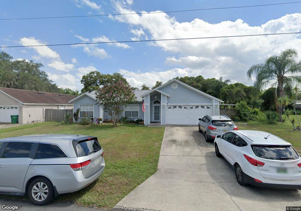
This home is located at 4857 Hawley Rd, Cocoa, FL 32927 and is currently estimated at $329,415, approximately $192 per square foot. 4857 Hawley Rd is a home located in Brevard County with nearby schools including Atlantis Elementary School, Space Coast Junior/Senior High School, and Sculptor Charter School.
Ownership History
Date
Name
Owned For
Owner Type
Purchase Details
Closed on
Oct 6, 1995
Sold by
Faria James R and Faria Laura K
Bought by
Sanchez Michael S and Sanchez Connie Sue
Current Estimated Value
Home Financials for this Owner
Home Financials are based on the most recent Mortgage that was taken out on this home.
Original Mortgage
$81,000
Outstanding Balance
$575
Interest Rate
7.72%
Estimated Equity
$328,840
Purchase Details
Closed on
Nov 22, 1993
Sold by
Faria James R and Faria Laura K
Bought by
Faria James R and Faria Laura K
Create a Home Valuation Report for This Property
The Home Valuation Report is an in-depth analysis detailing your home's value as well as a comparison with similar homes in the area
Home Values in the Area
Average Home Value in this Area
Purchase History
| Date | Buyer | Sale Price | Title Company |
|---|---|---|---|
| Sanchez Michael S | $81,000 | -- | |
| Faria James R | -- | -- |
Source: Public Records
Mortgage History
| Date | Status | Borrower | Loan Amount |
|---|---|---|---|
| Open | Sanchez Michael S | $81,000 |
Source: Public Records
Tax History Compared to Growth
Tax History
| Year | Tax Paid | Tax Assessment Tax Assessment Total Assessment is a certain percentage of the fair market value that is determined by local assessors to be the total taxable value of land and additions on the property. | Land | Improvement |
|---|---|---|---|---|
| 2025 | $1,215 | $86,460 | -- | -- |
| 2024 | $1,179 | $84,150 | -- | -- |
| 2023 | $1,179 | $81,700 | $0 | $0 |
| 2022 | $1,096 | $79,330 | $0 | $0 |
| 2021 | $1,084 | $77,020 | $0 | $0 |
| 2020 | $1,018 | $75,960 | $0 | $0 |
| 2019 | $957 | $74,260 | $0 | $0 |
| 2018 | $958 | $72,880 | $0 | $0 |
| 2017 | $958 | $71,390 | $0 | $0 |
| 2016 | $967 | $69,930 | $18,000 | $51,930 |
| 2015 | $976 | $69,450 | $15,000 | $54,450 |
| 2014 | $981 | $68,900 | $11,000 | $57,900 |
Source: Public Records
Map
Nearby Homes
- 6735 Grissom Pkwy
- 4790 Greenhill St
- 6620 Grissom Pkwy
- 4760 Ivan St
- 0000 Grissom Pkwy
- 6390 Depot Ave
- 4688 Fairsun St
- 5130 Carter St
- 7035 Jasmine Ave
- 5155 Mayflower St
- 6499 Pleasant Ave
- 7155 Export Ave
- 00 Unknown
- 6375 Cable Ave
- 5165 Patricia St
- 6760 Cairo Rd
- 5200 Frisco St
- 5265 Fay Blvd
- 7245 Grissom Pkwy
- 4975 Fay Blvd
- 4845 Hawley Rd
- 4910 Brookhaven St
- 4900 Brookhaven St
- 4920 Brookhaven St
- 4863 Hawley Rd
- 4833 Hawley Rd
- 4850 Hawley Rd
- 4860 Hawley Rd
- 4840 Hawley Rd
- 4890 Brookhaven St
- 4930 Brookhaven St
- 4821 Hawley Rd
- 4830 Hawley Rd
- 4867 Hawley Rd
- 4940 Brookhaven St
- 4880 Brookhaven St
- 4925 Curtis Blvd
- 4905 Brookhaven St
- 4820 Hawley Rd
- 4915 Brookhaven St