Estimated Value: $135,000 - $152,492
--
Bed
1
Bath
1,608
Sq Ft
$90/Sq Ft
Est. Value
About This Home
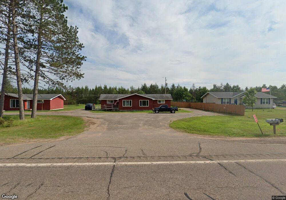
This home is located at 487 E State Highway M35 Unit 489, Gwinn, MI 49841 and is currently estimated at $145,164, approximately $90 per square foot. 487 E State Highway M35 Unit 489 is a home located in Marquette County with nearby schools including K.I. Sawyer Elementary School and Gwinn Middle/High School.
Ownership History
Date
Name
Owned For
Owner Type
Purchase Details
Closed on
Feb 15, 2023
Sold by
Spencer David S and Spencer Jennifer L
Bought by
Takalo Rentals Llc
Current Estimated Value
Home Financials for this Owner
Home Financials are based on the most recent Mortgage that was taken out on this home.
Original Mortgage
$172,785
Outstanding Balance
$167,509
Interest Rate
6.48%
Mortgage Type
New Conventional
Estimated Equity
-$22,345
Create a Home Valuation Report for This Property
The Home Valuation Report is an in-depth analysis detailing your home's value as well as a comparison with similar homes in the area
Home Values in the Area
Average Home Value in this Area
Purchase History
| Date | Buyer | Sale Price | Title Company |
|---|---|---|---|
| Takalo Rentals Llc | $200,000 | -- |
Source: Public Records
Mortgage History
| Date | Status | Borrower | Loan Amount |
|---|---|---|---|
| Open | Takalo Rentals Llc | $172,785 |
Source: Public Records
Tax History Compared to Growth
Tax History
| Year | Tax Paid | Tax Assessment Tax Assessment Total Assessment is a certain percentage of the fair market value that is determined by local assessors to be the total taxable value of land and additions on the property. | Land | Improvement |
|---|---|---|---|---|
| 2025 | $7 | $51,900 | $0 | $0 |
| 2024 | $7 | $44,600 | $0 | $0 |
| 2023 | $676 | $52,800 | $0 | $0 |
| 2022 | $2,109 | $41,300 | $0 | $0 |
| 2021 | $2,044 | $41,300 | $0 | $0 |
| 2020 | $2,043 | $41,300 | $0 | $0 |
| 2019 | $1,961 | $40,700 | $0 | $0 |
| 2018 | $2,166 | $45,000 | $0 | $0 |
| 2017 | $1,096 | $23,850 | $0 | $0 |
| 2016 | $1,089 | $23,350 | $0 | $0 |
| 2015 | -- | $23,350 | $0 | $0 |
| 2014 | -- | $23,700 | $0 | $0 |
| 2012 | -- | $25,300 | $0 | $0 |
Source: Public Records
Map
Nearby Homes
- 215 Driftwood Dr
- 115 N M553
- 115 N Marshall Dr
- 171 E Sands St
- 148 E Sands St
- 71 E Stephenson Ave
- 192 Johnson Lake Rd
- Parcel 6 Off Johnson Lake Rd
- Parcel 7 Off Johnson Lake Rd
- Parcel 4 Off Johnson Lake Rd
- Parcel 8 Off Johnson Lake Rd
- on S Bertrand Lake Rd
- 353 S Johnson Lake Dr
- Parcel 1 Iron Pin Trail
- Parcel 3 Iron Pin Trail
- 149 N Spruce St
- Parcel 5 S Rice Lake Dr
- Parcel 4 S Rice Lake Dr
- Parcel 3 S Rice Lake Dr
- Parcel 2 S Rice Lake Dr
- 487 E State Highway M35 Unit 487,489,495,497
- 471 E State Highway M35
- 495 E State Highway M35 Unit 497
- 487 E State Highway M35 Unit 487,489,495,497
- 384 and 396 E M35
- 384 and 396 E M35
- 397 E State Highway M35
- 387 E State Highway M35
- 387 Michigan 35
- 411 E State Highway M35
- 381 E State Highway M35
- 381 E State Highway M35
- 381 E State Highway M35
- 419 E State Highway M35
- 419 E State Highway M35
- 419 E State Highway M35
- 419 Michigan 35
- TBD Off E M35
- 425 E State Highway M35
- 433 E State Highway M35