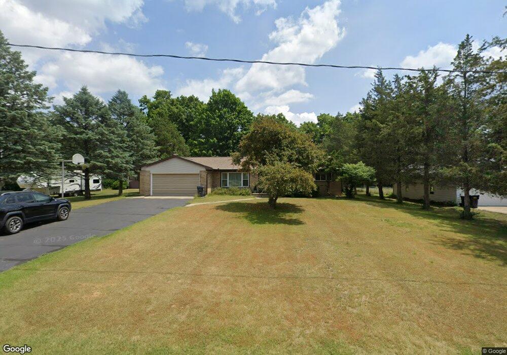
487 Earl St Otsego, MI 49078
Estimated Value: $243,000 - $275,000
3
Beds
2
Baths
1,402
Sq Ft
$181/Sq Ft
Est. Value
About This Home
This home is located at 487 Earl St, Otsego, MI 49078 and is currently estimated at $253,906, approximately $181 per square foot. 487 Earl St is a home located in Allegan County with nearby schools including Otsego High School, Otsego Christian Academy, and St. Margaret School.
Ownership History
Date
Name
Owned For
Owner Type
Purchase Details
Closed on
Jun 26, 2013
Sold by
Farnsworth Joseph A
Bought by
Weirick Cathy Lynn
Current Estimated Value
Purchase Details
Closed on
Aug 16, 2005
Sold by
Grinnewald Peggy L and Grinnewald Carl H
Bought by
Farnsworth Joseph A and Farnsworth Cathy
Create a Home Valuation Report for This Property
The Home Valuation Report is an in-depth analysis detailing your home's value as well as a comparison with similar homes in the area
Home Values in the Area
Average Home Value in this Area
Purchase History
| Date | Buyer | Sale Price | Title Company |
|---|---|---|---|
| Weirick Cathy Lynn | -- | None Available | |
| Farnsworth Joseph A | $20,000 | Devon |
Source: Public Records
Tax History Compared to Growth
Tax History
| Year | Tax Paid | Tax Assessment Tax Assessment Total Assessment is a certain percentage of the fair market value that is determined by local assessors to be the total taxable value of land and additions on the property. | Land | Improvement |
|---|---|---|---|---|
| 2025 | $2,502 | $120,600 | $8,300 | $112,300 |
| 2024 | $2,112 | $116,500 | $7,000 | $109,500 |
| 2023 | $2,149 | $98,800 | $7,000 | $91,800 |
| 2022 | $2,112 | $93,100 | $6,800 | $86,300 |
| 2021 | $1,994 | $89,700 | $8,300 | $81,400 |
| 2020 | $1,970 | $78,900 | $6,500 | $72,400 |
| 2019 | $1,905 | $75,500 | $6,500 | $69,000 |
| 2018 | $1,864 | $71,400 | $6,300 | $65,100 |
| 2017 | $0 | $73,100 | $10,000 | $63,100 |
| 2016 | $0 | $65,300 | $6,000 | $59,300 |
| 2015 | -- | $65,300 | $6,000 | $59,300 |
| 2014 | $3,031 | $57,200 | $5,300 | $51,900 |
| 2013 | $3,031 | $62,200 | $5,800 | $56,400 |
Source: Public Records
Map
Nearby Homes
- 602 Lincoln Rd
- 0 Lincoln Rd
- 552 19th St
- 624 Nicholson St
- 589 Lincoln Rd
- 0 Briarwood St Unit 25002251
- 365 W Orleans St
- 346 W Orleans St
- 233 W Hammond St
- 2108 Fox Mountain Dr
- 1651 Aspen Trail
- 1643 Aspen Trail
- 318 S Fair St
- 1647 Aspen Trail
- 1635 Aspen Trail
- 1431 Michigan 89
- 132 W River St
- Elements 1870 Plan at Southpointe Trails
- Integrity 1605 Plan at Southpointe Trails
- Elements 2070 Plan at Southpointe Trails