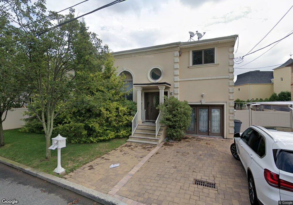
487 Lipsett Ave Staten Island, NY 10312
Annadale NeighborhoodEstimated Value: $1,007,728 - $1,398,000
3
Beds
3
Baths
2,418
Sq Ft
$485/Sq Ft
Est. Value
About This Home
This home is located at 487 Lipsett Ave, Staten Island, NY 10312 and is currently estimated at $1,173,932, approximately $485 per square foot. 487 Lipsett Ave is a home located in Richmond County with nearby schools including P.S. 5 - Huguenot, I.S. 007 Elias Bernstein, and Tottenville High School.
Ownership History
Date
Name
Owned For
Owner Type
Purchase Details
Closed on
Nov 30, 2004
Sold by
4Th Niro Inc
Bought by
Pogosyan Karen and Pogosyan Natalya
Current Estimated Value
Home Financials for this Owner
Home Financials are based on the most recent Mortgage that was taken out on this home.
Original Mortgage
$502,500
Interest Rate
5.73%
Mortgage Type
New Conventional
Purchase Details
Closed on
Mar 13, 2001
Sold by
Oceanview Development Company Llc
Bought by
High Land Creation Inc
Create a Home Valuation Report for This Property
The Home Valuation Report is an in-depth analysis detailing your home's value as well as a comparison with similar homes in the area
Home Values in the Area
Average Home Value in this Area
Purchase History
| Date | Buyer | Sale Price | Title Company |
|---|---|---|---|
| Pogosyan Karen | $682,225 | -- | |
| High Land Creation Inc | $235,000 | -- |
Source: Public Records
Mortgage History
| Date | Status | Borrower | Loan Amount |
|---|---|---|---|
| Previous Owner | Pogosyan Karen | $502,500 |
Source: Public Records
Tax History Compared to Growth
Tax History
| Year | Tax Paid | Tax Assessment Tax Assessment Total Assessment is a certain percentage of the fair market value that is determined by local assessors to be the total taxable value of land and additions on the property. | Land | Improvement |
|---|---|---|---|---|
| 2025 | $10,037 | $58,860 | $12,948 | $45,912 |
| 2024 | $10,049 | $54,960 | $13,516 | $41,444 |
| 2023 | $9,558 | $48,463 | $13,108 | $35,355 |
| 2022 | $8,840 | $52,860 | $14,460 | $38,400 |
| 2021 | $8,940 | $54,420 | $14,460 | $39,960 |
| 2020 | $9,001 | $48,300 | $14,460 | $33,840 |
| 2019 | $8,662 | $45,180 | $14,460 | $30,720 |
| 2018 | $7,935 | $40,386 | $11,855 | $28,531 |
| 2017 | $7,467 | $38,100 | $14,460 | $23,640 |
| 2016 | $7,007 | $36,600 | $14,460 | $22,140 |
| 2015 | $7,845 | $43,080 | $12,060 | $31,020 |
| 2014 | $7,845 | $42,468 | $11,889 | $30,579 |
Source: Public Records
Map
Nearby Homes
- 161 Boardwalk Ave
- 84 Discala Ln
- 21 Allen Place
- 262 Noel St
- 5 Nicolosi Dr
- 59 Newton St
- 47 Ravenna St
- 350 Poillon Ave
- 41 Bennett Place
- 344 Poillon Ave
- 440 Harold Ave
- 393 Philip Ave
- 389 Philip Ave
- 422 Harold Ave
- 383 Philip Ave
- 192 Bathgate St
- 16 Nicolosi Loop
- 52 Nicolosi Loop
- 111 Elmbank St
- 330 Shirley Ave