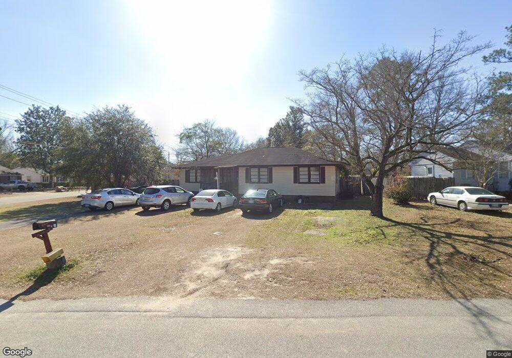
488 Allen Dr Sumter, SC 29150
Crosswell NeighborhoodEstimated Value: $72,492 - $147,000
4
Beds
2
Baths
1,474
Sq Ft
$76/Sq Ft
Est. Value
About This Home
This home is located at 488 Allen Dr, Sumter, SC 29150 and is currently estimated at $111,623, approximately $75 per square foot. 488 Allen Dr is a home located in Sumter County with nearby schools including Crosswell Drive Elementary School, Chestnut Oaks Middle School, and Sumter High School.
Ownership History
Date
Name
Owned For
Owner Type
Purchase Details
Closed on
Oct 31, 2008
Sold by
Conner Phillip K
Bought by
Conner Michael P and 488 Allen Drive Trust
Current Estimated Value
Home Financials for this Owner
Home Financials are based on the most recent Mortgage that was taken out on this home.
Original Mortgage
$58,800
Outstanding Balance
$37,535
Interest Rate
5.78%
Mortgage Type
Unknown
Estimated Equity
$74,088
Purchase Details
Closed on
Oct 6, 2008
Sold by
Conner Michael P
Bought by
Conner Phillip K
Home Financials for this Owner
Home Financials are based on the most recent Mortgage that was taken out on this home.
Original Mortgage
$58,800
Outstanding Balance
$37,535
Interest Rate
5.78%
Mortgage Type
Unknown
Estimated Equity
$74,088
Purchase Details
Closed on
Jun 14, 2007
Sold by
Moore Harriett D
Bought by
Conner Michael P and 488 Allen Drive Trust
Create a Home Valuation Report for This Property
The Home Valuation Report is an in-depth analysis detailing your home's value as well as a comparison with similar homes in the area
Home Values in the Area
Average Home Value in this Area
Purchase History
| Date | Buyer | Sale Price | Title Company |
|---|---|---|---|
| Conner Michael P | -- | -- | |
| Conner Phillip K | -- | -- | |
| Conner Michael P | $34,000 | None Available |
Source: Public Records
Mortgage History
| Date | Status | Borrower | Loan Amount |
|---|---|---|---|
| Open | Conner Phillip K | $58,800 |
Source: Public Records
Tax History
| Year | Tax Paid | Tax Assessment Tax Assessment Total Assessment is a certain percentage of the fair market value that is determined by local assessors to be the total taxable value of land and additions on the property. | Land | Improvement |
|---|---|---|---|---|
| 2025 | $1,291 | $3,330 | $350 | $2,980 |
| 2024 | $1,291 | $3,330 | $350 | $2,980 |
| 2023 | $1,291 | $3,320 | $350 | $2,970 |
| 2022 | $1,281 | $3,320 | $350 | $2,970 |
| 2021 | $1,215 | $3,320 | $350 | $2,970 |
| 2020 | $1,215 | $3,070 | $350 | $2,720 |
| 2019 | $1,209 | $3,070 | $350 | $2,720 |
| 2018 | $1,214 | $3,070 | $350 | $2,720 |
| 2017 | $1,221 | $3,070 | $350 | $2,720 |
| 2016 | $1,205 | $3,070 | $350 | $2,720 |
| 2015 | $476 | $3,320 | $470 | $2,850 |
| 2014 | $476 | $2,220 | $320 | $1,900 |
| 2013 | -- | $2,220 | $320 | $1,900 |
Source: Public Records
Map
Nearby Homes
- 70 Lemmon St
- 110 Phifer St
- 52 Wilson St
- 313 Rutledge St
- 309 Pinckney St
- 33 White St
- 31 White St
- 23 White St
- 16 Strange St
- 113 Poinsett Dr
- 1002 Sterling St
- 2365 Day Lily St
- 1861 Wildhorse Dr
- 2360 Day Lily St
- 2395 Daylilly St Unit Lot 138
- 2345 Day Lily St
- 13 Victory Dr
- 206 Crosswell Dr
- 100 E Hunter St
- 201 Stark St
Your Personal Tour Guide
Ask me questions while you tour the home.