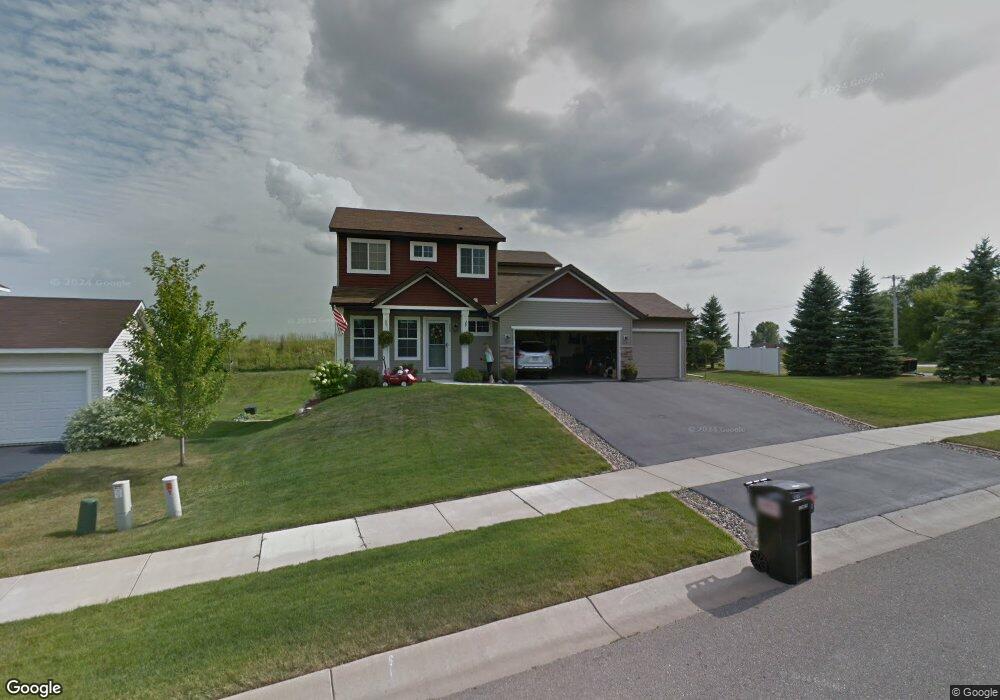
489 Amberg Ln Chaska, MN 55318
Estimated Value: $562,000 - $606,000
4
Beds
4
Baths
2,288
Sq Ft
$253/Sq Ft
Est. Value
About This Home
This home is located at 489 Amberg Ln, Chaska, MN 55318 and is currently estimated at $578,717, approximately $252 per square foot. 489 Amberg Ln is a home located in Carver County with nearby schools including Jonathan Elementary School, Chaska Middle School East, and Chaska High School.
Ownership History
Date
Name
Owned For
Owner Type
Purchase Details
Closed on
Apr 21, 2017
Sold by
Sondag Todd Joseph and Sondag Emily
Bought by
Johnson Brian J and Erickson Solveig R
Current Estimated Value
Home Financials for this Owner
Home Financials are based on the most recent Mortgage that was taken out on this home.
Original Mortgage
$356,000
Outstanding Balance
$295,349
Interest Rate
4.1%
Mortgage Type
New Conventional
Estimated Equity
$283,368
Purchase Details
Closed on
Sep 30, 2010
Sold by
Breckenridge Builders Inc
Bought by
Sondag Todd Joseph
Home Financials for this Owner
Home Financials are based on the most recent Mortgage that was taken out on this home.
Original Mortgage
$327,588
Interest Rate
4.25%
Mortgage Type
FHA
Purchase Details
Closed on
Jan 25, 2010
Sold by
Meridian Land Holdings Llc
Bought by
Bfeckenridge Builders Inc
Purchase Details
Closed on
Dec 2, 2004
Sold by
Epic Development V Llc
Bought by
The Windwood Co Inc
Create a Home Valuation Report for This Property
The Home Valuation Report is an in-depth analysis detailing your home's value as well as a comparison with similar homes in the area
Home Values in the Area
Average Home Value in this Area
Purchase History
| Date | Buyer | Sale Price | Title Company |
|---|---|---|---|
| Johnson Brian J | $375,000 | Executive Title | |
| Sondag Todd Joseph | $332,000 | -- | |
| Bfeckenridge Builders Inc | $75,000 | -- | |
| The Windwood Co Inc | $3,780,000 | -- |
Source: Public Records
Mortgage History
| Date | Status | Borrower | Loan Amount |
|---|---|---|---|
| Open | Johnson Brian J | $356,000 | |
| Previous Owner | Sondag Todd Joseph | $327,588 |
Source: Public Records
Tax History Compared to Growth
Tax History
| Year | Tax Paid | Tax Assessment Tax Assessment Total Assessment is a certain percentage of the fair market value that is determined by local assessors to be the total taxable value of land and additions on the property. | Land | Improvement |
|---|---|---|---|---|
| 2025 | $6,128 | $548,600 | $150,000 | $398,600 |
| 2024 | $5,534 | $509,200 | $115,000 | $394,200 |
| 2023 | $5,282 | $471,800 | $100,000 | $371,800 |
| 2022 | $5,072 | $470,000 | $98,200 | $371,800 |
| 2021 | $4,778 | $395,800 | $81,800 | $314,000 |
| 2020 | $4,898 | $402,200 | $81,800 | $320,400 |
| 2019 | $4,798 | $377,900 | $77,900 | $300,000 |
| 2018 | $4,882 | $377,900 | $77,900 | $300,000 |
| 2017 | $4,956 | $434,900 | $70,900 | $364,000 |
| 2016 | $5,400 | $391,900 | $0 | $0 |
| 2015 | $4,598 | $369,500 | $0 | $0 |
| 2014 | $4,598 | $317,700 | $0 | $0 |
Source: Public Records
Map
Nearby Homes
- 6513 Timber Arch Dr
- 475 Oakhill Rd
- 1746 White Oak Dr
- 1725 White Oak Dr
- 2173 Grimm Rd
- 110282 Village Rd
- 110102 Arboretum Way
- 887 Braunworth Ct Unit 165
- 110309 Center Green Cir
- 110312 Center Green Cir
- 1976 Clover Ridge Dr
- 110696 Village Rd Unit 219
- 715 Liberty Heights Dr
- 2275 Clover Field Dr
- 1385 White Oak Dr
- 1521 Crest Dr
- 314 Campfire Curve
- 661 Satori Way
- 312 Wagon Wheel Ln Unit 16
- 2732 Wagon Wheel Curve Unit 11