Estimated Value: $273,000 - $295,000
3
Beds
3
Baths
1,916
Sq Ft
$148/Sq Ft
Est. Value
About This Home
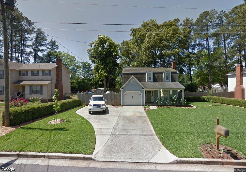
This home is located at 489 Pheasant Run Dr, Evans, GA 30809 and is currently estimated at $284,518, approximately $148 per square foot. 489 Pheasant Run Dr is a home located in Columbia County with nearby schools including Evans Elementary School, Evans Middle School, and Evans High School.
Ownership History
Date
Name
Owned For
Owner Type
Purchase Details
Closed on
Feb 28, 2020
Sold by
Bookhart Matthew C
Bought by
Karius Kathryn and Ogrady Andrew
Current Estimated Value
Home Financials for this Owner
Home Financials are based on the most recent Mortgage that was taken out on this home.
Original Mortgage
$175,750
Outstanding Balance
$155,317
Interest Rate
3.5%
Mortgage Type
New Conventional
Estimated Equity
$129,202
Purchase Details
Closed on
Dec 20, 2002
Sold by
Peterson Todd N and Peterson Diana
Bought by
Bookhart Matthew C
Home Financials for this Owner
Home Financials are based on the most recent Mortgage that was taken out on this home.
Original Mortgage
$95,900
Interest Rate
5.99%
Create a Home Valuation Report for This Property
The Home Valuation Report is an in-depth analysis detailing your home's value as well as a comparison with similar homes in the area
Home Values in the Area
Average Home Value in this Area
Purchase History
| Date | Buyer | Sale Price | Title Company |
|---|---|---|---|
| Karius Kathryn | $197,500 | -- | |
| Bookhart Matthew C | $98,900 | -- |
Source: Public Records
Mortgage History
| Date | Status | Borrower | Loan Amount |
|---|---|---|---|
| Open | Karius Kathryn | $175,750 | |
| Previous Owner | Bookhart Matthew C | $95,900 |
Source: Public Records
Tax History
| Year | Tax Paid | Tax Assessment Tax Assessment Total Assessment is a certain percentage of the fair market value that is determined by local assessors to be the total taxable value of land and additions on the property. | Land | Improvement |
|---|---|---|---|---|
| 2025 | $2,908 | $121,999 | $18,804 | $103,195 |
| 2024 | $2,945 | $117,946 | $18,804 | $99,142 |
| 2023 | $2,945 | $99,195 | $15,204 | $83,991 |
| 2022 | $2,345 | $90,285 | $15,304 | $74,981 |
| 2021 | $2,147 | $79,000 | $13,600 | $65,400 |
| 2020 | $1,747 | $64,910 | $11,804 | $53,106 |
| 2019 | $1,802 | $66,877 | $12,204 | $54,673 |
| 2018 | $1,664 | $61,676 | $11,204 | $50,472 |
| 2017 | $1,680 | $62,065 | $10,704 | $51,361 |
| 2016 | $1,773 | $67,807 | $11,380 | $56,427 |
| 2015 | $1,593 | $61,010 | $8,480 | $52,530 |
| 2014 | $1,567 | $59,341 | $9,280 | $50,061 |
Source: Public Records
Map
Nearby Homes
- 525 Pheasant Run Dr
- 4421 Hereford Farm Rd
- 625 Dunloe Cir
- 648 River Oaks Ln
- 854 Sparkleberry Rd
- 456 Connemara Trail
- 4560 Mulberry Creek Dr
- 809 Woodberry Dr
- 2820 Old Riah Rd
- 435 Evans Mill Dr Unit 17
- 4484 Woodberry Ct
- 726 Whitney Shoals Rd
- 881 Audubon Way
- 814 Audubon Way
- 4489 Woodberry Ct
- 4481 Woodberry Ct
- 606 Ridge Way
- 829 Woodberry Dr
- 780 Springbrook Cir
- 628 Emerald Crossing
- 487 Pheasant Run Dr
- 491 Pheasant Run Dr
- 493 Pheasant Run Dr
- 485 Pheasant Run Dr
- 491 Rachel Dr
- 490 Pheasant Run Dr
- 488 Pheasant Run Dr
- 490 Pheasant Run Dr
- 489 Rachel Dr
- 487 Rachel Dr
- 484 Pheasant Run Dr
- 495 Pheasant Run Dr
- 483 Pheasant Run Dr
- 494 Pheasant Run Dr
- 485 Rachel Dr
- 462 Skeet Ct
- 298 Lake Jean Dr
- 497 Pheasant Run Dr
- 480 Pheasant Run Dr
- 481 Pheasant Run Dr
Your Personal Tour Guide
Ask me questions while you tour the home.