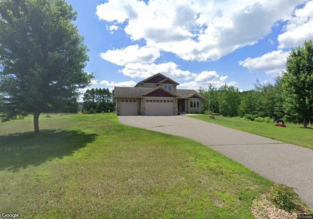
4890 201st Ave NE Wyoming, MN 55092
Estimated Value: $499,000 - $588,000
3
Beds
3
Baths
1,967
Sq Ft
$278/Sq Ft
Est. Value
About This Home
This home is located at 4890 201st Ave NE, Wyoming, MN 55092 and is currently estimated at $547,737, approximately $278 per square foot. 4890 201st Ave NE is a home located in Anoka County with nearby schools including Linwood Elementary School and Forest Lake Area High School.
Ownership History
Date
Name
Owned For
Owner Type
Purchase Details
Closed on
Sep 20, 2019
Sold by
Crockett Julia R and Crockett Dirk W
Bought by
Pauly Michael T and Pauty Philmana M
Current Estimated Value
Home Financials for this Owner
Home Financials are based on the most recent Mortgage that was taken out on this home.
Original Mortgage
$220,150
Outstanding Balance
$143,739
Interest Rate
3%
Mortgage Type
New Conventional
Estimated Equity
$403,998
Purchase Details
Closed on
Mar 1, 2019
Sold by
Hennen Verna F and Hennen Lee A
Bought by
Crockett Dirk W and Crockett Julia Raye
Home Financials for this Owner
Home Financials are based on the most recent Mortgage that was taken out on this home.
Original Mortgage
$319,724
Interest Rate
5%
Mortgage Type
Land Contract Argmt. Of Sale
Create a Home Valuation Report for This Property
The Home Valuation Report is an in-depth analysis detailing your home's value as well as a comparison with similar homes in the area
Home Values in the Area
Average Home Value in this Area
Purchase History
| Date | Buyer | Sale Price | Title Company |
|---|---|---|---|
| Pauly Michael T | $344,000 | Burnet Title | |
| Crockett Drik W | $345,000 | None Available | |
| Crockett Dirk W | $319,724 | None Available |
Source: Public Records
Mortgage History
| Date | Status | Borrower | Loan Amount |
|---|---|---|---|
| Open | Crockett Drik W | $220,150 | |
| Previous Owner | Crockett Dirk W | $319,724 |
Source: Public Records
Tax History Compared to Growth
Tax History
| Year | Tax Paid | Tax Assessment Tax Assessment Total Assessment is a certain percentage of the fair market value that is determined by local assessors to be the total taxable value of land and additions on the property. | Land | Improvement |
|---|---|---|---|---|
| 2025 | $4,787 | $484,100 | $110,500 | $373,600 |
| 2024 | $4,787 | $477,600 | $101,200 | $376,400 |
| 2023 | $4,185 | $473,100 | $94,000 | $379,100 |
| 2022 | $3,907 | $444,500 | $77,500 | $367,000 |
| 2021 | $3,925 | $358,900 | $66,800 | $292,100 |
| 2020 | $489 | $338,100 | $55,300 | $282,800 |
| 2019 | $3,680 | $307,500 | $38,300 | $269,200 |
| 2018 | $3,412 | $295,800 | $0 | $0 |
| 2017 | $3,428 | $286,800 | $0 | $0 |
| 2016 | $3,105 | $243,000 | $0 | $0 |
| 2015 | -- | $243,000 | $40,300 | $202,700 |
| 2014 | -- | $224,500 | $50,200 | $174,300 |
Source: Public Records
Map
Nearby Homes
- 5160 202nd Ln NE
- 20136 Erskine St NE
- 20715 Minnie B Grant Ln NE
- 21087 National St NE
- 21061 Kissel St NE
- 4310 Channel Ln NE
- 20826 Austin St NE
- 21205 Viking Blvd NE
- 21057 Tippecanoe St NE
- xxx Birch Rd
- 20852 Okinawa St NE
- lot 3 217th Ave NE
- 426 Birch Rd
- 21207 Tippecanoe St NE
- LOT 2 217th Ave NE
- lot 1 217th Ave NE
- L2,4XXX 217th Ave NE
- L1, XXXX 217th Ave NE
- 21795 Willys St NE
- 19479 Leyte St NE
- X 201st Ave NE
- 4910 201st Ave NE
- XXXX Stutz St NE
- xxxx 241st Ave NE
- 4887 201st Ave NE
- 20061 Wild Rice Dr NE
- xxxx Stutz St
- 20028 Stutz St NE
- L4 B1 201st Ave NE
- xxxx NE 201st Ave
- 20033 Wild Rice Dr NE
- 4952 201st Ave NE
- 20021 Wild Rice Dr NE
- 19992 Stutz St NE
- xxxx 201st (Lot 4 Blk 2) St NE
- L1 B1 201st Ave NE
- 20015 Stutz St NE
- 4988 201st Ave NE
- L1 B1 Stutz--
- 4991 201st Ave NE