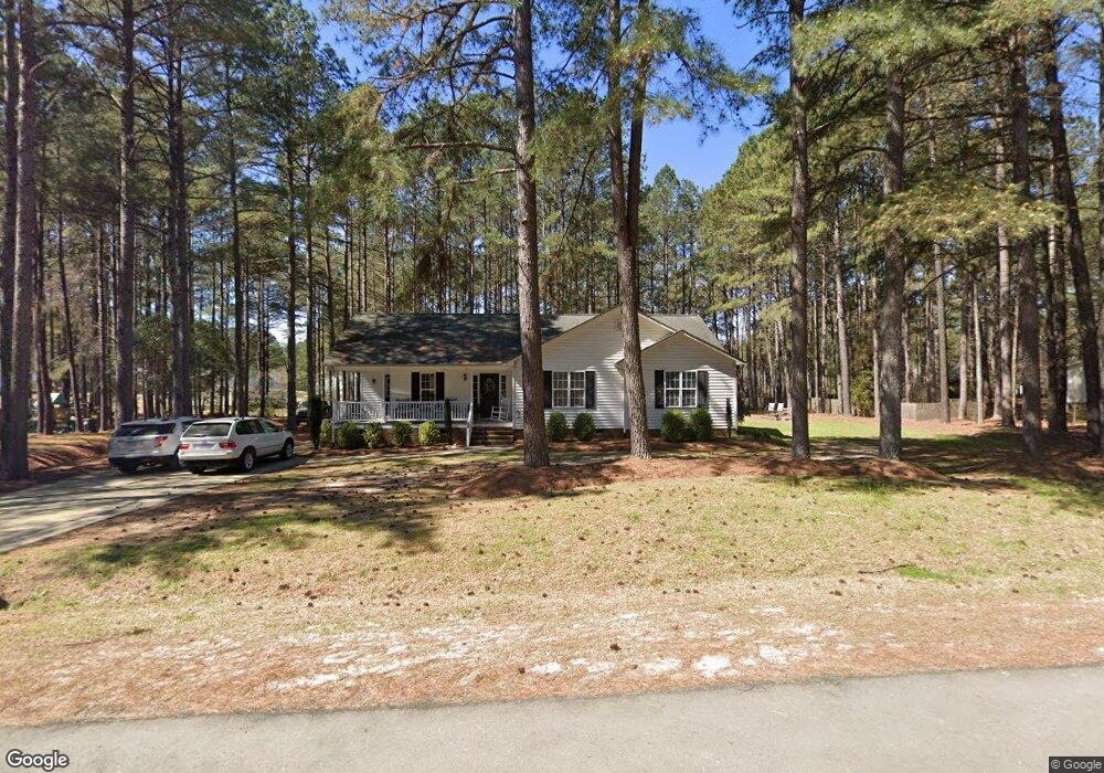
49 Abram Way Clayton, NC 27520
Cleveland NeighborhoodEstimated Value: $306,000 - $343,000
3
Beds
2
Baths
1,420
Sq Ft
$226/Sq Ft
Est. Value
About This Home
This home is located at 49 Abram Way, Clayton, NC 27520 and is currently estimated at $320,589, approximately $225 per square foot. 49 Abram Way is a home located in Johnston County with nearby schools including Cleveland Elementary School, Cleveland Middle School, and Cleveland High School.
Ownership History
Date
Name
Owned For
Owner Type
Purchase Details
Closed on
Dec 28, 2012
Sold by
Smith Linda P
Bought by
Hall Larry Anderson
Current Estimated Value
Home Financials for this Owner
Home Financials are based on the most recent Mortgage that was taken out on this home.
Original Mortgage
$132,653
Outstanding Balance
$92,191
Interest Rate
3.36%
Mortgage Type
New Conventional
Estimated Equity
$228,398
Purchase Details
Closed on
Aug 13, 2010
Sold by
Petty Michelle and Ussery Thomas R
Bought by
Smith Linda P
Purchase Details
Closed on
Nov 5, 2009
Sold by
Petty Jon C and Petty Michelle
Bought by
Petty Michelle
Purchase Details
Closed on
Apr 25, 2002
Sold by
Rees Michelle M
Bought by
Parker Homes Inc
Purchase Details
Closed on
Jan 22, 2002
Sold by
Parker Homes Inc
Bought by
Deuce Investments Inc
Create a Home Valuation Report for This Property
The Home Valuation Report is an in-depth analysis detailing your home's value as well as a comparison with similar homes in the area
Home Values in the Area
Average Home Value in this Area
Purchase History
| Date | Buyer | Sale Price | Title Company |
|---|---|---|---|
| Hall Larry Anderson | $130,000 | None Available | |
| Smith Linda P | $136,500 | None Available | |
| Petty Michelle | -- | None Available | |
| Parker Homes Inc | $130,000 | -- | |
| Deuce Investments Inc | $30,000 | -- |
Source: Public Records
Mortgage History
| Date | Status | Borrower | Loan Amount |
|---|---|---|---|
| Open | Hall Larry Anderson | $132,653 |
Source: Public Records
Tax History Compared to Growth
Tax History
| Year | Tax Paid | Tax Assessment Tax Assessment Total Assessment is a certain percentage of the fair market value that is determined by local assessors to be the total taxable value of land and additions on the property. | Land | Improvement |
|---|---|---|---|---|
| 2025 | $1,823 | $287,050 | $83,160 | $203,890 |
| 2024 | $1,362 | $168,190 | $44,350 | $123,840 |
| 2023 | $1,316 | $168,190 | $44,350 | $123,840 |
| 2022 | $1,383 | $168,190 | $44,350 | $123,840 |
| 2021 | $1,383 | $168,190 | $44,350 | $123,840 |
| 2020 | $1,400 | $168,190 | $44,350 | $123,840 |
| 2019 | $1,400 | $168,190 | $44,350 | $123,840 |
| 2018 | $1,130 | $132,510 | $29,570 | $102,940 |
| 2017 | $1,130 | $132,510 | $29,570 | $102,940 |
| 2016 | $1,130 | $132,510 | $29,570 | $102,940 |
| 2015 | $1,130 | $132,510 | $29,570 | $102,940 |
| 2014 | $1,130 | $132,510 | $29,570 | $102,940 |
Source: Public Records
Map
Nearby Homes
- 208 Hunting Lodge Rd
- 147 E Wellesley Dr
- The Buford II Plan at Wellesley
- The Harrington Plan at Wellesley
- The Caldwell Plan at Wellesley
- The Braselton II Plan at Wellesley
- The Greenbrier II Plan at Wellesley
- The Bradley Plan at Wellesley
- The McGinnis Plan at Wellesley
- 619 Rudy Dr
- 99 Barton Bay Ln
- 280 Ambassador Dr
- 290 Ambassador Dr
- 305 Ambassador Dr
- 302 Ambassador Dr
- 320 Ambassador Dr
- 330 Ambassador Dr
- 84 Commons Cir
- 340 Ambassador Dr
- 349 Ambassador Dr
- 77 Abram Way
- 234 Lassiter Farms Ln
- 46 Moser Place
- 198 Lassiter Farms Ln
- 74 Moser Place
- 20 Moser Place
- 78 Abram Way
- 178 Lassiter Farms Ln
- 235 Lassiter Farms Ln
- 245 Lassiter Farms Ln
- 245 Lassiter Farms Ln Unit lt 15
- 102 Abram Way
- 197 Lassiter Farms Ln
- 90 Moser Place
- 158 Lassiter Farms Ln
- 49 Moser Place
- 275 Lassiter Farms Ln
- 85 Troy Dr
- 25 Moser Place
- 63 Troy Dr