


49 Acres Summer Creek CV & John King Rd Crestview, FL 32539
Estimated payment $2,148/month
About This Lot
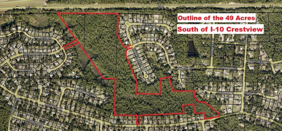
SOUTH OF I-10 IN CRESTVIEW - 49 ACRES WITH MULTIPLE ACCESS POINTS. THIS IS A RARE FIND! CHECK OUT THE PHOTOS - 4 Separate Parcel ID #s. Paved Road Frontage to include the following locations between 356 & 358 John King Road, between 386 & 406 John King Rd, the back part of STONEBRIDGE SUBDIVISION, between 2822 Penny Ln & 4820 Summer Creek Cv. There is a city access to the Property on West Old Mill Way between 101 Mill Stone Cv & 101 Mill Pond Cv. The Parcel ID Numbers are as follows: 28-3N-23-0000-0018-0000, 28-3N-23-0000-0017-0000, 28-3N-23-0000-0017-0020, 33-3N-23-0000-0001-0000. Buyer to do their due diligence with their intended use of the property. The Property can also be sold in 2 separate parcels of 22.24 Acres off John King or 26.76 Acres off Old Mill & Summer Creek. CLICK MORE This is vacant land. The seller has never occupied the property. There are no property disclosures. The buyer is responsible to satisfy themselves with any information they deem important. The due diligence period should be completed within 30 days.
Property Details
Property Type
- Land
Lot Details
- 49 Acre Lot
- Property is zoned City, County
Schools
- Riverside Elementary School
- Shoal River Middle School
- Crestview High School
Community Details
- Multiple Stonebridge, John King Rd, Old Mill Way See 4 Parcel Id #S Subdivision
Listing and Financial Details
- Assessor Parcel Number 28-3N-23-0000-0017-0000
Map
Home Values in the Area
Average Home Value in this Area
Tax History
| Year | Tax Paid | Tax Assessment Tax Assessment Total Assessment is a certain percentage of the fair market value that is determined by local assessors to be the total taxable value of land and additions on the property. | Land | Improvement |
|---|---|---|---|---|
| 2024 | $842 | $58,790 | $58,790 | -- |
| 2023 | $842 | $52,026 | $52,026 | $0 |
| 2022 | $807 | $49,548 | $49,548 | $0 |
| 2021 | $754 | $45,044 | $45,044 | $0 |
| 2020 | $759 | $45,044 | $45,044 | $0 |
| 2019 | $766 | $45,044 | $45,044 | $0 |
| 2018 | $774 | $45,044 | $0 | $0 |
| 2017 | $784 | $45,044 | $0 | $0 |
| 2016 | $780 | $45,044 | $0 | $0 |
| 2015 | $797 | $45,044 | $0 | $0 |
| 2014 | $795 | $47,415 | $0 | $0 |
Property History
| Date | Event | Price | List to Sale | Price per Sq Ft |
|---|---|---|---|---|
| 09/10/2025 09/10/25 | For Sale | $395,000 | -- | -- |
Purchase History
| Date | Type | Sale Price | Title Company |
|---|---|---|---|
| Warranty Deed | $100,000 | Knight Barry Title |
Source: Emerald Coast Association of REALTORS®
MLS Number: 985020
APN: 28-3N-23-0000-0017-0000
Disclaimer: Certain information contained herein is derived from information provided by parties other than Homes.com. All information provided is deemed reliable, but is not guaranteed to be accurate and should be independently verified.
![]() IDX information is provided exclusively for personal, non-commercial use, and may not be used for any purpose other than to identify prospective properties consumers may be interested in purchasing. Information is deemed reliable but not guaranteed.
IDX information is provided exclusively for personal, non-commercial use, and may not be used for any purpose other than to identify prospective properties consumers may be interested in purchasing. Information is deemed reliable but not guaranteed.
- 26.76 Acre Summer Creek - West Old Mill
- 354 John King Rd
- 231 Lyla Ln
- 165 Blooming Cove
- 105 Cedar Point Rd
- 109 Blooming Cove
- 157 Blooming Cove
- 200 Walker Cir W
- 223 Pinoak Ct W
- 719 Majestic Prince Ct
- 4730 Connor Dr
- 643 Alysheba Dr
- 607 Affirmed Ct
- 144 Oak Terrace Dr
- 519 White Oak Ln
- 4720 Whitewater Ln
- 2837 Tamiami Trail
- 4759 Connor Dr
- 147 Nicole Ln
- 2852 Atoka Trail
- 150 W Old Mill Way
- 643 Alysheba Dr
- 423 John King Rd
- 2837 Atoka Trail
- 309 Green Oak Dr
- 414 Whirlaway Ct
- 2813 Atoka Trail
- 207 Swaying Pine Ct
- 639 Brookmeade Dr
- 103 Trenton Ave
- 123 Oak Terrace Dr
- 4695 Lovegrass Ln
- 144 Swaying Pine Ct
- 1016 Limpkin St
- 357 Crooked Pine Trail
- 910 Merganser Way
- 300 Cassady Ln
- 301 E Redstone Ave
- 925 Merganser Way
- 931 Merganser Way
