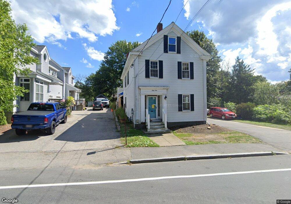
49 East St Ipswich, MA 01938
Estimated Value: $802,000 - $969,000
4
Beds
2
Baths
1,900
Sq Ft
$453/Sq Ft
Est. Value
About This Home
This home is located at 49 East St, Ipswich, MA 01938 and is currently estimated at $859,933, approximately $452 per square foot. 49 East St is a home located in Essex County with nearby schools including Ipswich High School, North Shore Montessori School, and Pingree School.
Ownership History
Date
Name
Owned For
Owner Type
Purchase Details
Closed on
Nov 30, 2023
Sold by
Bento George M and Bento Kathy M
Bought by
Bento Rachel
Current Estimated Value
Purchase Details
Closed on
Sep 29, 2023
Sold by
Bento Rachel
Bought by
Bento George M and Bento Kathy M
Purchase Details
Closed on
Jul 31, 2023
Sold by
Bento George M and Bento Kathy M
Bought by
Bento Rachel
Purchase Details
Closed on
Feb 14, 1997
Sold by
Speakman Phyllis B
Bought by
Bento George M and Bento Kathy M
Create a Home Valuation Report for This Property
The Home Valuation Report is an in-depth analysis detailing your home's value as well as a comparison with similar homes in the area
Home Values in the Area
Average Home Value in this Area
Purchase History
| Date | Buyer | Sale Price | Title Company |
|---|---|---|---|
| Bento Rachel | -- | None Available | |
| Bento Rachel | -- | None Available | |
| Bento Rachel | -- | None Available | |
| Bento Rachel | -- | None Available | |
| Bento George M | -- | None Available | |
| Bento George M | -- | None Available | |
| Bento George M | -- | None Available | |
| Bento George M | -- | None Available | |
| Bento Rachel | $625,000 | None Available | |
| Bento George M | $220,000 | -- | |
| Bento George M | $220,000 | -- |
Source: Public Records
Mortgage History
| Date | Status | Borrower | Loan Amount |
|---|---|---|---|
| Previous Owner | Bento George M | $143,000 | |
| Previous Owner | Bento George M | $110,000 |
Source: Public Records
Tax History
| Year | Tax Paid | Tax Assessment Tax Assessment Total Assessment is a certain percentage of the fair market value that is determined by local assessors to be the total taxable value of land and additions on the property. | Land | Improvement |
|---|---|---|---|---|
| 2025 | $8,132 | $729,300 | $296,600 | $432,700 |
| 2024 | $6,853 | $602,200 | $296,900 | $305,300 |
| 2023 | $6,472 | $529,200 | $253,500 | $275,700 |
| 2022 | $6,240 | $485,200 | $239,000 | $246,200 |
| 2021 | $6,114 | $462,500 | $235,400 | $227,100 |
| 2020 | $6,554 | $467,500 | $240,800 | $226,700 |
| 2019 | $6,287 | $446,200 | $229,900 | $216,300 |
| 2018 | $5,977 | $419,700 | $217,300 | $202,400 |
| 2017 | $5,801 | $408,800 | $206,400 | $202,400 |
| 2016 | $5,226 | $351,900 | $173,800 | $178,100 |
| 2015 | $4,707 | $348,400 | $170,200 | $178,200 |
Source: Public Records
Map
Nearby Homes
- 57 East St
- 29 Summer St Unit 15
- 7 Woods Ln
- 64 County Rd Unit 1
- 59 S Main St Unit 1
- 11 Washington St Unit 11
- 11 Washington St Unit 8
- 11 Washington St Unit 7
- 11 Washington St Unit 5
- 11 Washington St Unit 4
- 11 Washington St Unit 12
- 2 Heartbreak Hill
- 8 Cleveland Ave
- 5 Primrose Ln Unit 5
- 9 Ryan Ave
- 23 Jeffrey's Neck Rd
- 500 Colonial Dr Unit 5
- 24 Primrose Ln Unit 24
- 123 Jeffreys Neck Rd
- 133 Topsfield Rd
Your Personal Tour Guide
Ask me questions while you tour the home.