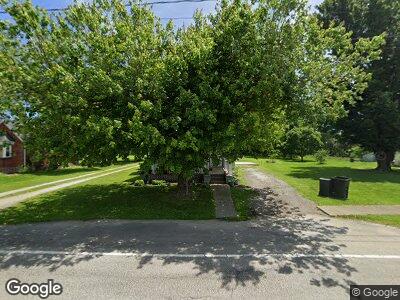
49 High St Unit 1 Sardinia, OH 45171
Estimated Value: $127,000 - $221,000
4
Beds
1
Bath
1,580
Sq Ft
$114/Sq Ft
Est. Value
About This Home
This home is located at 49 High St Unit 1, Sardinia, OH 45171 and is currently estimated at $179,845, approximately $113 per square foot. 49 High St Unit 1 is a home located in Highland County with nearby schools including Bright Elementary School, Whiteoak Junior High School, and Whiteoak High School.
Ownership History
Date
Name
Owned For
Owner Type
Purchase Details
Closed on
Sep 21, 2017
Sold by
Juillerat Klayton and Juillerat Kara
Bought by
Price Travis and Wardlow Loren
Current Estimated Value
Home Financials for this Owner
Home Financials are based on the most recent Mortgage that was taken out on this home.
Original Mortgage
$114,141
Outstanding Balance
$96,423
Interest Rate
3.89%
Mortgage Type
Future Advance Clause Open End Mortgage
Estimated Equity
$83,422
Purchase Details
Closed on
Feb 23, 2017
Sold by
Fannie Mae
Bought by
Juillerat Klayton and Juillerat Kara
Purchase Details
Closed on
Jun 6, 2016
Sold by
Gibson Kathy
Bought by
Federal National Mortgage Association
Purchase Details
Closed on
Jan 1, 1990
Bought by
Costello Mary E
Create a Home Valuation Report for This Property
The Home Valuation Report is an in-depth analysis detailing your home's value as well as a comparison with similar homes in the area
Home Values in the Area
Average Home Value in this Area
Purchase History
| Date | Buyer | Sale Price | Title Company |
|---|---|---|---|
| Price Travis | $113,500 | Technetitle Agency | |
| Juillerat Klayton | $47,101 | Technetitle Agency | |
| Federal National Mortgage Association | -- | Nova Title Agency Inc | |
| Costello Mary E | -- | -- |
Source: Public Records
Mortgage History
| Date | Status | Borrower | Loan Amount |
|---|---|---|---|
| Open | Price Travis | $114,141 |
Source: Public Records
Tax History Compared to Growth
Tax History
| Year | Tax Paid | Tax Assessment Tax Assessment Total Assessment is a certain percentage of the fair market value that is determined by local assessors to be the total taxable value of land and additions on the property. | Land | Improvement |
|---|---|---|---|---|
| 2024 | $2,089 | $58,460 | $15,300 | $43,160 |
| 2023 | $2,089 | $42,810 | $11,800 | $31,010 |
| 2022 | $1,893 | $42,810 | $11,800 | $31,010 |
| 2021 | $1,895 | $42,810 | $11,800 | $31,010 |
| 2020 | $1,801 | $38,890 | $10,710 | $28,180 |
| 2019 | $1,792 | $38,890 | $10,710 | $28,180 |
| 2018 | $1,375 | $38,890 | $10,710 | $28,180 |
| 2017 | $954 | $18,730 | $3,360 | $15,370 |
| 2016 | $1,632 | $18,730 | $3,360 | $15,370 |
| 2015 | $957 | $18,730 | $3,360 | $15,370 |
| 2014 | $956 | $17,820 | $3,190 | $14,630 |
| 2013 | $990 | $17,820 | $3,190 | $14,630 |
Source: Public Records
Map
Nearby Homes
- 36 Main St W
- 6 Walnut St
- 55 W Main St
- 8928 Katterman Rd
- 9354 Katterman Rd
- 2226 Gath Rd
- 935 Garvey Rd
- 7451 Brookfield Place
- 12824 Heaton Rd
- 0 N St Rt 32 Unit 1745639
- 111 Dewey Dr
- Ac Bachman Rd
- 1514 Sitting Bull Dr
- 13.3 ac Freeh Rd
- 13 Freeh Rd
- 0 Mochican Cove Unit 1833148
- 0 Arnheim Ashridge Rd Unit 1821389
- 0 Creek - Lot# 2795 Dr Unit 1803735
- 1254 Gath Rd
- 2011 Moccasin Dr
