
Seller's Agent in 2025
Rick Nazzaro
Colonial Manor Realty
(781) 290-7425
113 in this area
176 Total Sales
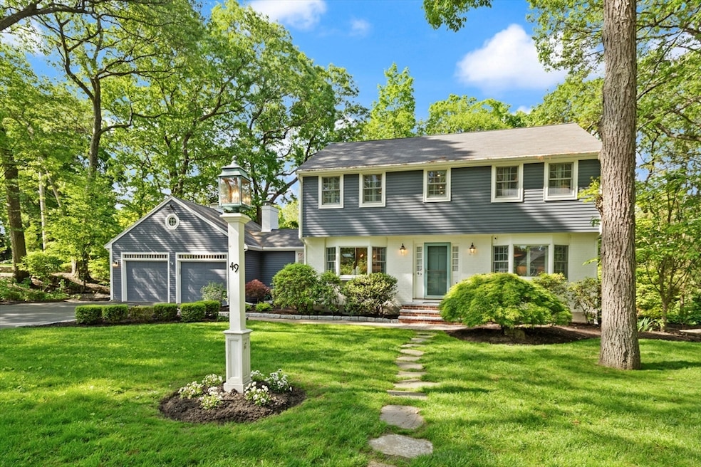
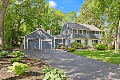
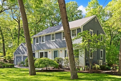
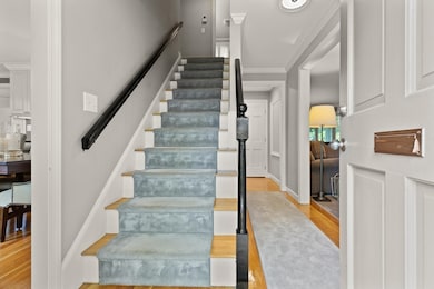
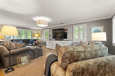


This ideally located W. side Col is the definition of "CUSTOM!" Carefully renovated by a sought after local interior designer, along w/the thoughtful eye of the owners, where quality, function & style all ranked high in the selections made. Breathtaking at every turn, each detail is exquisite. From polished nickel hardware, designer lighting, crown moldings, wainscoting & NUMEROUS custom BUILT-INS, to the grass cloth wall treatment, silk draperies & plantation shutters, your new home will be admired by all who enter. The chef's kitchen is rich in finishes...cherry cabinetry, HI-END appliances, an expansive peninsula w/seating, all opening up to a sun-filled FR w/walls of windows, skylights & a gorgeous FP. From here, your outdoor oasis awaits...done to perfection! A HUGE deck, patio & expansive lawns make it the place to be! W/4 beautiful bdrms & 3 STUNNING spa-like baths, there's room for all. An expertly fin. LL for exercising or entertaining is done w/ease...the wet bar is AMAZING!
| Date | Type | Sale Price | Title Company |
|---|---|---|---|
| Quit Claim Deed | $1,300,000 | -- | |
| Deed | $1,300,000 | -- | |
| Quit Claim Deed | -- | None Available | |
| Deed | $507,500 | -- |
| Date | Status | Loan Amount | Loan Type |
|---|---|---|---|
| Open | $1,040,000 | Purchase Money Mortgage | |
| Closed | $1,040,000 | New Conventional | |
| Previous Owner | $387,000 | No Value Available | |
| Previous Owner | $378,500 | Purchase Money Mortgage |
| Date | Event | Price | List to Sale | Price per Sq Ft |
|---|---|---|---|---|
| 08/15/2025 08/15/25 | Sold | $1,300,000 | +0.1% | $491 / Sq Ft |
| 06/04/2025 06/04/25 | Pending | -- | -- | -- |
| 05/29/2025 05/29/25 | For Sale | $1,299,000 | -- | $490 / Sq Ft |
| Year | Tax Paid | Tax Assessment Tax Assessment Total Assessment is a certain percentage of the fair market value that is determined by local assessors to be the total taxable value of land and additions on the property. | Land | Improvement |
|---|---|---|---|---|
| 2025 | $11,521 | $1,011,500 | $597,900 | $413,600 |
| 2024 | $11,661 | $995,000 | $588,100 | $406,900 |
| 2023 | $10,976 | $871,800 | $515,200 | $356,600 |
| 2022 | $10,965 | $822,600 | $486,100 | $336,500 |
| 2021 | $10,456 | $757,100 | $444,700 | $312,400 |
| 2020 | $10,044 | $720,000 | $422,900 | $297,100 |
| 2019 | $6,558 | $676,600 | $397,400 | $279,200 |
| 2018 | $6,034 | $633,100 | $371,800 | $261,300 |
| 2017 | $6,158 | $620,700 | $364,500 | $256,200 |
| 2016 | $9,277 | $639,800 | $330,800 | $309,000 |
| 2015 | $8,595 | $584,700 | $302,100 | $282,600 |
| 2014 | $8,533 | $578,900 | $299,100 | $279,800 |
Seller's Agent in 2025
Rick Nazzaro
Colonial Manor Realty
(781) 290-7425
113 in this area
176 Total Sales
Buyer's Agent in 2025
Katie Varney
Classified Realty Group
(617) 596-4512
47 in this area
71 Total Sales
Source: MLS Property Information Network (MLS PIN)
MLS Number: 73381810
APN: READ-000006-000000-000037
Disclaimer: Certain information contained herein is derived from information provided by parties other than Homes.com. All information provided is deemed reliable, but is not guaranteed to be accurate and should be independently verified.
![]() The property listing data and information, or the Images, set forth herein were provided to MLS Property Information Network, Inc. from third party sources, including sellers, lessors and public records, and were compiled by MLS Property Information Network, Inc. The property listing data and information, and the Images, are for the personal, non-commercial use of consumers having a good faith interest in purchasing or leasing listed properties of the type displayed to them and may not be used for any purpose other than to identify prospective properties which such consumers may have a good faith interest in purchasing or leasing. MLS Property Information Network, Inc. and its subscribers disclaim any and all representations and warranties as to the accuracy of the property listing data and information, or as to the accuracy of any of the Images, set forth herein.
The property listing data and information, or the Images, set forth herein were provided to MLS Property Information Network, Inc. from third party sources, including sellers, lessors and public records, and were compiled by MLS Property Information Network, Inc. The property listing data and information, and the Images, are for the personal, non-commercial use of consumers having a good faith interest in purchasing or leasing listed properties of the type displayed to them and may not be used for any purpose other than to identify prospective properties which such consumers may have a good faith interest in purchasing or leasing. MLS Property Information Network, Inc. and its subscribers disclaim any and all representations and warranties as to the accuracy of the property listing data and information, or as to the accuracy of any of the Images, set forth herein.
Ask me questions while you tour the home.