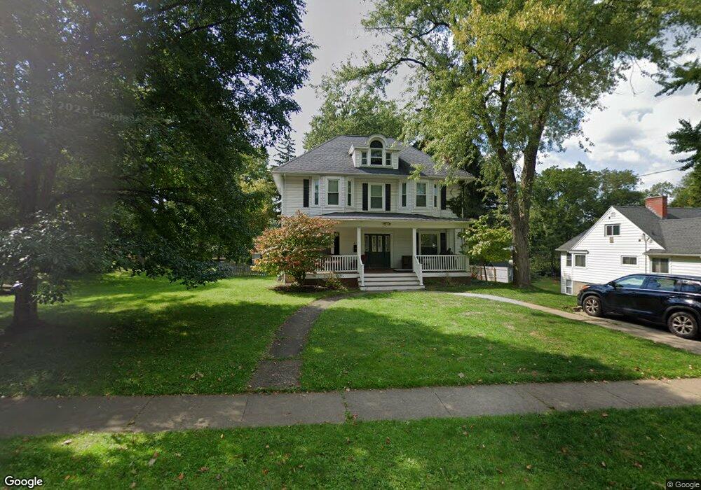
49 Maple Rd East Aurora, NY 14052
Estimated Value: $582,000 - $894,000
4
Beds
6
Baths
3,996
Sq Ft
$197/Sq Ft
Est. Value
About This Home
This home is located at 49 Maple Rd, East Aurora, NY 14052 and is currently estimated at $789,164, approximately $197 per square foot. 49 Maple Rd is a home located in Erie County with nearby schools including Parkdale Elementary School, East Aurora Middle School, and East Aurora High School.
Ownership History
Date
Name
Owned For
Owner Type
Purchase Details
Closed on
Dec 12, 2006
Sold by
Federal Home Loan Mortgage Corporation
Bought by
Mumm Jennifer J and Mumm Jason A
Current Estimated Value
Home Financials for this Owner
Home Financials are based on the most recent Mortgage that was taken out on this home.
Original Mortgage
$318,100
Outstanding Balance
$190,185
Interest Rate
6.31%
Mortgage Type
Purchase Money Mortgage
Estimated Equity
$598,979
Purchase Details
Closed on
Dec 19, 2000
Sold by
Protos Michael C and Protos Jill M
Bought by
Kern Courtney P
Home Financials for this Owner
Home Financials are based on the most recent Mortgage that was taken out on this home.
Original Mortgage
$171,000
Interest Rate
7.71%
Purchase Details
Closed on
Dec 7, 1995
Sold by
Wolf Richard L
Bought by
Protos Michael C and Protos Jill M
Create a Home Valuation Report for This Property
The Home Valuation Report is an in-depth analysis detailing your home's value as well as a comparison with similar homes in the area
Home Values in the Area
Average Home Value in this Area
Purchase History
| Date | Buyer | Sale Price | Title Company |
|---|---|---|---|
| Mumm Jennifer J | $334,900 | First Amer Title Ins Co Ny | |
| Kern Courtney P | $180,000 | -- | |
| Protos Michael C | $190,000 | -- |
Source: Public Records
Mortgage History
| Date | Status | Borrower | Loan Amount |
|---|---|---|---|
| Open | Mumm Jennifer J | $318,100 | |
| Previous Owner | Kern Courtney P | $171,000 |
Source: Public Records
Tax History Compared to Growth
Tax History
| Year | Tax Paid | Tax Assessment Tax Assessment Total Assessment is a certain percentage of the fair market value that is determined by local assessors to be the total taxable value of land and additions on the property. | Land | Improvement |
|---|---|---|---|---|
| 2024 | $14,328 | $145,700 | $8,400 | $137,300 |
| 2023 | $13,904 | $145,700 | $8,400 | $137,300 |
| 2022 | $13,726 | $145,700 | $8,400 | $137,300 |
| 2021 | $10,561 | $145,700 | $8,400 | $137,300 |
| 2020 | $11,676 | $145,700 | $8,400 | $137,300 |
| 2019 | $10,720 | $145,700 | $8,400 | $137,300 |
| 2018 | $11,832 | $145,700 | $8,400 | $137,300 |
| 2017 | $3,115 | $145,700 | $8,400 | $137,300 |
| 2016 | $10,839 | $145,700 | $8,400 | $137,300 |
| 2015 | -- | $145,700 | $8,400 | $137,300 |
| 2014 | -- | $145,700 | $8,400 | $137,300 |
Source: Public Records
Map
Nearby Homes
- 172 Maple Rd
- 35 Hamlin Ave
- 116 Hamlin Ave
- 51 Paine St
- 1823 Center St
- 584 Oakwood Ave
- 81 Church St
- 424 Linden Ave
- 7 Woodbrook Dr Unit 3
- 36 Hillcrest Rd
- 270 Buffalo Rd Unit 60
- 132 Beech Rd
- 46 Bowen Rd
- 22 Highland Dr
- 555 South St
- 217 Bowen Rd
- 831 Lawrence Ave
- VL South St
- 842 Oakwood Ave
- 4050 Martingale Ct