
Seller's Agent in 2025
Christy Gibbs
Gibbs Realty Inc.
(508) 873-8356
3 in this area
150 Total Sales

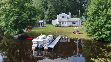
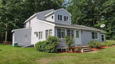
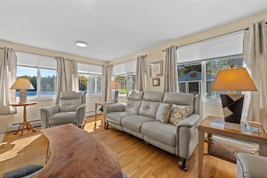
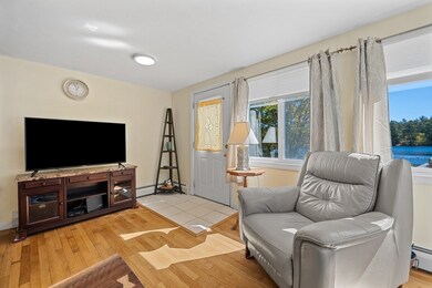
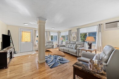
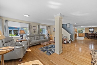
Waterfront Retreat on Dean Pond - Southern Exposure– 130 feet of PRIVATE water frontage, just 15 miles from Worcester! This home offers the perfect year-round escape for boating, kayaking, and fishing enthusiasts. With Title 5 in hand, the property is ready for immediate enjoyment. The open floor plan features Kitchen with Dining Area and spacious Living Room with stunning Water Views. Hardwood floors and an original stone fireplace with pellet stove add charm and warmth. The first floor includes a bedroom with pine finishes, a full bath with laundry, and walk-in storage. Upstairs, the private main suite boasts a cathedral ceiling, 3-season sitting room with more Water Views, a jet tub bath, and a walk-in closet. Additional perks include a 2-bay carport and a screened porch for outdoor relaxation. Start planning your waterfront adventures today—this home offers the perfect blend of comfort and nature. Welcome home!
| Date | Type | Sale Price | Title Company |
|---|---|---|---|
| Quit Claim Deed | $400,000 | -- | |
| Deed | $76,250 | -- |
| Date | Status | Loan Amount | Loan Type |
|---|---|---|---|
| Open | $280,000 | New Conventional | |
| Previous Owner | $65,000 | No Value Available | |
| Previous Owner | $62,800 | No Value Available | |
| Previous Owner | $61,000 | Purchase Money Mortgage |
| Date | Event | Price | List to Sale | Price per Sq Ft |
|---|---|---|---|---|
| 12/09/2025 12/09/25 | Sold | $400,000 | -7.0% | $231 / Sq Ft |
| 10/24/2025 10/24/25 | Pending | -- | -- | -- |
| 10/03/2025 10/03/25 | For Sale | $429,900 | -- | $248 / Sq Ft |
| Year | Tax Paid | Tax Assessment Tax Assessment Total Assessment is a certain percentage of the fair market value that is determined by local assessors to be the total taxable value of land and additions on the property. | Land | Improvement |
|---|---|---|---|---|
| 2025 | $4,310 | $373,200 | $165,700 | $207,500 |
| 2024 | $4,059 | $366,300 | $162,400 | $203,900 |
| 2023 | $3,886 | $335,900 | $142,500 | $193,400 |
| 2022 | $3,658 | $287,600 | $123,900 | $163,700 |
| 2021 | $3,034 | $233,000 | $120,300 | $112,700 |
| 2020 | $2,954 | $218,000 | $119,100 | $98,900 |
| 2019 | $3,033 | $209,000 | $112,400 | $96,600 |
| 2018 | $2,883 | $189,700 | $97,700 | $92,000 |
| 2017 | $2,703 | $189,700 | $97,700 | $92,000 |
| 2016 | $2,546 | $183,200 | $91,900 | $91,300 |
| 2015 | $2,506 | $183,200 | $91,900 | $91,300 |
| 2014 | $2,374 | $183,200 | $91,900 | $91,300 |
Seller's Agent in 2025
Christy Gibbs
Gibbs Realty Inc.
(508) 873-8356
3 in this area
150 Total Sales
S
Buyer's Agent in 2025
Sebastian Roy
Today Real Estate, Inc.
(413) 687-0053
1 in this area
3 Total Sales
Source: MLS Property Information Network (MLS PIN)
MLS Number: 73439536
APN: OAKH-000510-000000-000200
Disclaimer: Certain information contained herein is derived from information provided by parties other than Homes.com. All information provided is deemed reliable, but is not guaranteed to be accurate and should be independently verified.
![]() The property listing data and information, or the Images, set forth herein were provided to MLS Property Information Network, Inc. from third party sources, including sellers, lessors and public records, and were compiled by MLS Property Information Network, Inc. The property listing data and information, and the Images, are for the personal, non-commercial use of consumers having a good faith interest in purchasing or leasing listed properties of the type displayed to them and may not be used for any purpose other than to identify prospective properties which such consumers may have a good faith interest in purchasing or leasing. MLS Property Information Network, Inc. and its subscribers disclaim any and all representations and warranties as to the accuracy of the property listing data and information, or as to the accuracy of any of the Images, set forth herein.
The property listing data and information, or the Images, set forth herein were provided to MLS Property Information Network, Inc. from third party sources, including sellers, lessors and public records, and were compiled by MLS Property Information Network, Inc. The property listing data and information, and the Images, are for the personal, non-commercial use of consumers having a good faith interest in purchasing or leasing listed properties of the type displayed to them and may not be used for any purpose other than to identify prospective properties which such consumers may have a good faith interest in purchasing or leasing. MLS Property Information Network, Inc. and its subscribers disclaim any and all representations and warranties as to the accuracy of the property listing data and information, or as to the accuracy of any of the Images, set forth herein.
Ask me questions while you tour the home.