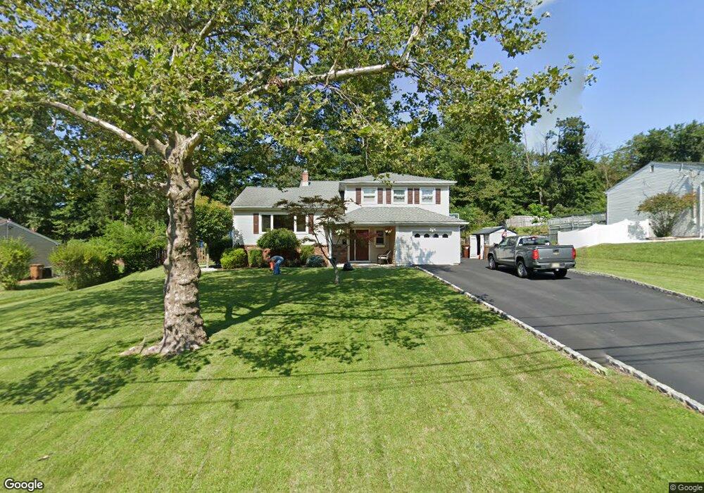
49 Shady Ln Bound Brook, NJ 08805
Estimated Value: $573,294 - $685,000
--
Bed
--
Bath
1,819
Sq Ft
$347/Sq Ft
Est. Value
About This Home
This home is located at 49 Shady Ln, Bound Brook, NJ 08805 and is currently estimated at $630,824, approximately $346 per square foot. 49 Shady Ln is a home located in Somerset County with nearby schools including Adamsville Primary School, Bridgewater-Raritan Middle School, and Hillside Intermediate School.
Ownership History
Date
Name
Owned For
Owner Type
Purchase Details
Closed on
Aug 11, 2011
Sold by
Cortese Louis S and Cortese Marianne
Bought by
Stacknick Dennis and Stacknick Annette
Current Estimated Value
Home Financials for this Owner
Home Financials are based on the most recent Mortgage that was taken out on this home.
Original Mortgage
$368,650
Outstanding Balance
$242,157
Interest Rate
3.5%
Mortgage Type
FHA
Estimated Equity
$388,667
Create a Home Valuation Report for This Property
The Home Valuation Report is an in-depth analysis detailing your home's value as well as a comparison with similar homes in the area
Home Values in the Area
Average Home Value in this Area
Purchase History
| Date | Buyer | Sale Price | Title Company |
|---|---|---|---|
| Stacknick Dennis | $390,000 | Crystal Title Agency Llc |
Source: Public Records
Mortgage History
| Date | Status | Borrower | Loan Amount |
|---|---|---|---|
| Open | Stacknick Dennis | $368,650 |
Source: Public Records
Tax History Compared to Growth
Tax History
| Year | Tax Paid | Tax Assessment Tax Assessment Total Assessment is a certain percentage of the fair market value that is determined by local assessors to be the total taxable value of land and additions on the property. | Land | Improvement |
|---|---|---|---|---|
| 2025 | $8,826 | $465,700 | $222,200 | $243,500 |
| 2024 | $8,826 | $447,800 | $222,200 | $225,600 |
| 2023 | $8,106 | $403,900 | $222,200 | $181,700 |
| 2022 | $7,800 | $373,900 | $217,200 | $156,700 |
| 2021 | $7,582 | $364,900 | $217,200 | $147,700 |
| 2020 | $7,569 | $355,700 | $217,200 | $138,500 |
| 2019 | $7,582 | $352,800 | $217,200 | $135,600 |
| 2018 | $7,313 | $341,100 | $217,200 | $123,900 |
| 2017 | $7,144 | $332,900 | $217,200 | $115,700 |
| 2016 | $7,032 | $332,500 | $217,200 | $115,300 |
| 2015 | $6,981 | $330,400 | $217,200 | $113,200 |
| 2014 | $6,866 | $320,100 | $217,200 | $102,900 |
Source: Public Records
Map
Nearby Homes
- 1740 Middlebrook Rd
- 143 Vosseller Ave
- 745 Schoolhouse Ln
- 617 Vosseller Ave
- 606 Vosseller Ave
- 180 Farm Ln
- 563 Winsor St
- 650 Central Ave
- 520 Winsor St
- 601 Thompson Ave
- 307 W Union Ave
- 1820 Woodland Terrace
- 641 Crescent Dr
- 807 Watchung Rd
- 301 Stratford Place
- 722 Lawrence Rd
- 811 Mountain Ave
- 504 Stratford Place
- 14 E Maple Ave
- 102 W Franklin St