
PENDING
$20K PRICE DROP
49 Stark Hwy N Dunbarton, NH 03046
Estimated payment $4,206/month
Total Views
4,960
3
Beds
3.5
Baths
2,599
Sq Ft
$260
Price per Sq Ft
Highlights
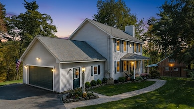
- Barn
- 4.41 Acre Lot
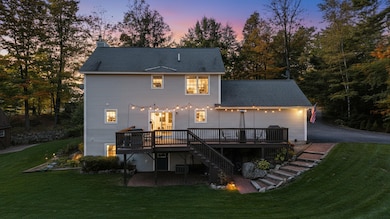
- Deck
- Bow High School Rated 9+
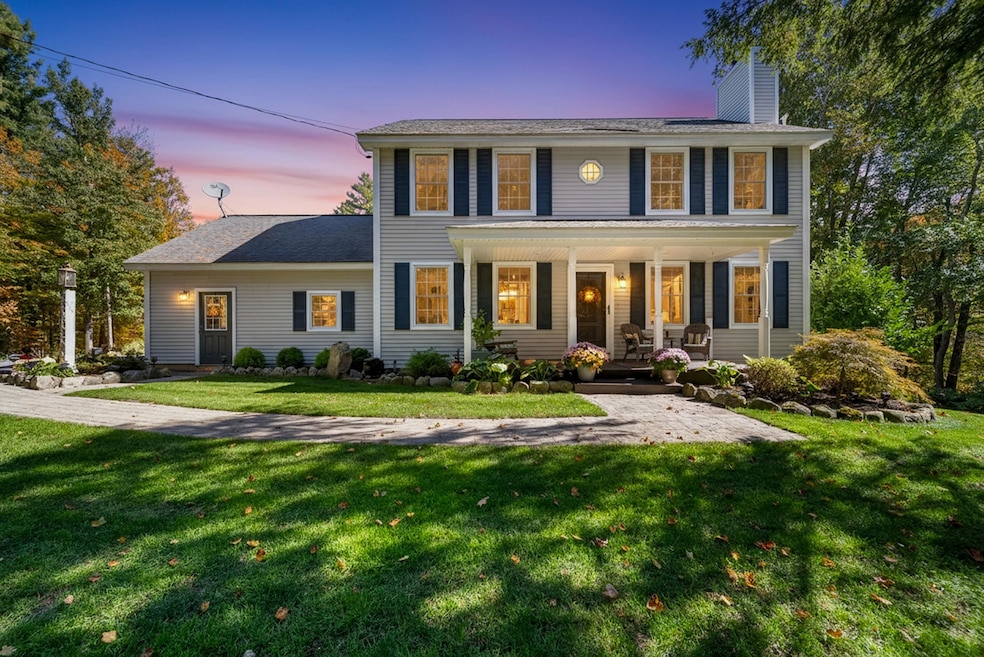
- Colonial Architecture
- Wooded Lot
About This Home
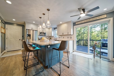
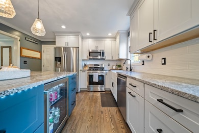
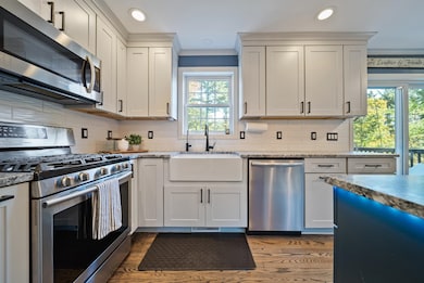
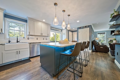
Privacy abounds at 49 Stark Highway North! A charming like new Colonial set on 4+ acres in beautiful Dunbarton, NH. This 3-bedroom, 4 bath home welcomes you with the thoughtfully renovated open-concept kitchen featuring a center island and stainless steel appliances, flowing seamlessly into the dining room and a sun-filled living room anchored by a cozy wood-burning fireplace. The first floor also includes a convenient half bath and laundry. Upstairs, the large primary suite with a large walk-in closet offers an updated full bath, while two additional spacious bedrooms share another full bath. The finished walkout basement expands the living space, complete with a charming 3/4 bath. Use as a second living room, workout room, home office or even a potential in-law. The wood stove offers an additional heat source. Outside, entertain or relax on the expansive deck overlooking the private yard. The 2-car attached garage offers additional storage, while the heated detached barn is perfect for hobbies or a workspace. Updates include gleaming hardwood floors and the renovated kitchen and baths. Heated by efficient liquid propane with a private well and septic, with a replaced leaching field. Dunbarton is a highly desirable town in the Bow school system, offering a charming small-town feel with quick access to Manchester, Concord, and the Lakes Region. Nothing to do but move in and enjoy! Showings begin at the Open House on Thursday, Oct 9th at 5PM or schedule a private tour!
Listing Agent
EXP Realty Brokerage Phone: 603-867-9072 License #072453 Listed on: 10/06/2025
Home Details
Home Type
- Single Family
Est. Annual Taxes
- $7,793
Year Built
- Built in 2002
Lot Details
- 4.41 Acre Lot
- Property fronts a private road
- Sloped Lot
- Wooded Lot
- Garden
Parking
- 2 Car Direct Access Garage
- Parking Storage or Cabinetry
- Automatic Garage Door Opener
- 1 to 5 Parking Spaces
Home Design
- Colonial Architecture
- Concrete Foundation
- Wood Frame Construction
- Vinyl Siding
Interior Spaces
- Property has 2 Levels
- Fireplace
- Family Room
- Dining Room
- Bonus Room
Kitchen
- Gas Range
- Microwave
- Dishwasher
- Kitchen Island
Flooring
- Wood
- Carpet
- Ceramic Tile
- Vinyl
Bedrooms and Bathrooms
- 3 Bedrooms
- En-Suite Bathroom
Laundry
- Laundry Room
- Dryer
- Washer
Finished Basement
- Walk-Out Basement
- Basement Fills Entire Space Under The House
Outdoor Features
- Deck
- Patio
- Outdoor Storage
- Outbuilding
Schools
- Dunbarton Elementary School
- Bow Memorial Middle School
- Bow High School
Farming
- Barn
Utilities
- Forced Air Heating and Cooling System
- Hot Water Heating System
- Private Water Source
- Drilled Well
- Septic Tank
- Phone Available
- Cable TV Available
Community Details
- Trails
Listing and Financial Details
- Legal Lot and Block 09 / 03
- Assessor Parcel Number F3
Map
Create a Home Valuation Report for This Property
The Home Valuation Report is an in-depth analysis detailing your home's value as well as a comparison with similar homes in the area
Home Values in the Area
Average Home Value in this Area
Tax History
| Year | Tax Paid | Tax Assessment Tax Assessment Total Assessment is a certain percentage of the fair market value that is determined by local assessors to be the total taxable value of land and additions on the property. | Land | Improvement |
|---|---|---|---|---|
| 2024 | $7,793 | $295,400 | $77,800 | $217,600 |
| 2023 | $7,553 | $295,400 | $77,800 | $217,600 |
| 2022 | $6,788 | $295,400 | $77,800 | $217,600 |
| 2021 | $6,915 | $295,400 | $77,800 | $217,600 |
| 2020 | $6,582 | $295,400 | $77,800 | $217,600 |
| 2018 | $5,286 | $234,600 | $64,200 | $170,400 |
| 2017 | $6,008 | $234,600 | $64,200 | $170,400 |
| 2016 | $5,463 | $227,800 | $64,200 | $163,600 |
| 2015 | $5,374 | $227,800 | $64,200 | $163,600 |
| 2014 | $5,025 | $237,700 | $64,200 | $173,500 |
| 2013 | $4,994 | $237,700 | $64,200 | $173,500 |
Source: Public Records
Property History
| Date | Event | Price | List to Sale | Price per Sq Ft |
|---|---|---|---|---|
| 10/31/2025 10/31/25 | Pending | -- | -- | -- |
| 10/27/2025 10/27/25 | Price Changed | $675,000 | -2.9% | $260 / Sq Ft |
| 10/06/2025 10/06/25 | For Sale | $695,000 | -- | $267 / Sq Ft |
Source: PrimeMLS
Purchase History
| Date | Type | Sale Price | Title Company |
|---|---|---|---|
| Warranty Deed | $204,100 | -- |
Source: Public Records
Mortgage History
| Date | Status | Loan Amount | Loan Type |
|---|---|---|---|
| Open | $243,750 | Unknown | |
| Closed | $52,000 | Unknown | |
| Closed | $189,100 | No Value Available |
Source: Public Records
About the Listing Agent
Kimberley A. Tufts, M.Ed., NH & MA REALTOR®, PSA, ABR®, SRS, RESA®CSA™, CLHMS™, eXp Luxury, GUILD™ Recognition
Licensed since 2017, Kimberley Tufts is a Top 1% producing REALTOR® in New Hampshire and Massachusetts, recognized by Real Trends, a Luxury Certified eXp Luxury Realtor, CLHMS™ (Certified Luxury Home Marketing Specialist), and holds GUILD™ Recognition. She is the Founder of The Modern Group, the #1 eXp Realty Team in NH in 2024, and has helped over 300 families achieve their
Kimberley's Other Listings
Source: PrimeMLS
MLS Number: 5064601
APN: DUNB-000003-000003-000009-F000000
Disclaimer: Certain information contained herein is derived from information provided by parties other than Homes.com. All information provided is deemed reliable, but is not guaranteed to be accurate and should be independently verified.
![]() Copyright 2025 PrimeMLS, Inc. All rights reserved. This information is deemed reliable, but not guaranteed. The data relating to real estate displayed on this display comes in part from the IDX Program of PrimeMLS. The information being provided is for consumers’ personal, non-commercial use and may not be used for any purpose other than to identify prospective properties consumers may be interested in purchasing.
Copyright 2025 PrimeMLS, Inc. All rights reserved. This information is deemed reliable, but not guaranteed. The data relating to real estate displayed on this display comes in part from the IDX Program of PrimeMLS. The information being provided is for consumers’ personal, non-commercial use and may not be used for any purpose other than to identify prospective properties consumers may be interested in purchasing.
Nearby Homes
- 1003 School St
- 15 Robert Rogers Rd
- 78 Rangeway Rd
- 40 Gile Hill Rd
- 250 Grapevine Rd
- 70 Gile Hill Rd
- 68 Gile Hill Rd
- 30 Holiday Shore Dr
- 5 Longview Dr
- 1 Hop Kiln Rd
- 8 Longview Dr
- 3 Stephanie Rd
- 0 Brown Hill Rd Unit 5032600
- 31 Brown Hill Rd
- 16 Gorham Dr
- 104 Brown Hill Rd
- 490 Page Rd
- 0 Fairway Dr Unit 11
- I3-03-05 Clinton St
- 22 Fairway Dr