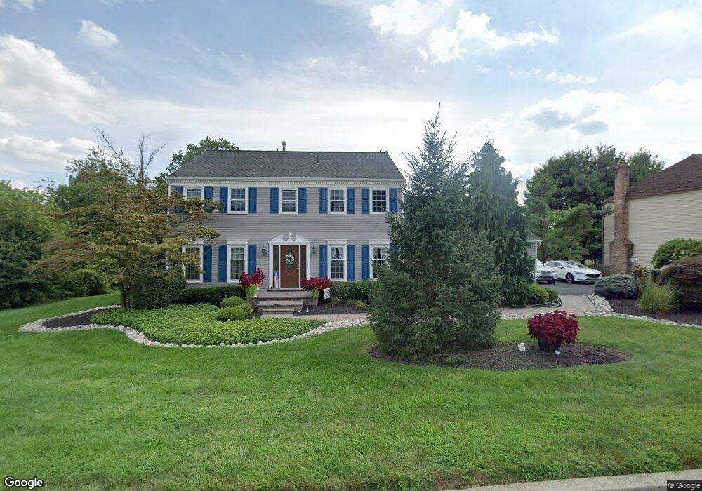
490 Denbign Rd Langhorne, PA 19047
Estimated Value: $691,000 - $765,000
4
Beds
3
Baths
2,602
Sq Ft
$283/Sq Ft
Est. Value
About This Home
This home is located at 490 Denbign Rd, Langhorne, PA 19047 and is currently estimated at $736,497, approximately $283 per square foot. 490 Denbign Rd is a home located in Bucks County with nearby schools including Pearl S. Buck Elementary School, Maple Point Middle School, and Neshaminy High School.
Ownership History
Date
Name
Owned For
Owner Type
Purchase Details
Closed on
Sep 27, 1996
Sold by
Henning George F and Henning June P
Bought by
Ambrosio Eugene F and Ambrosio Sandra E
Current Estimated Value
Home Financials for this Owner
Home Financials are based on the most recent Mortgage that was taken out on this home.
Original Mortgage
$165,000
Interest Rate
7.9%
Mortgage Type
Balloon
Purchase Details
Closed on
Apr 2, 1987
Bought by
Henning George F and Henning June P
Create a Home Valuation Report for This Property
The Home Valuation Report is an in-depth analysis detailing your home's value as well as a comparison with similar homes in the area
Home Values in the Area
Average Home Value in this Area
Purchase History
| Date | Buyer | Sale Price | Title Company |
|---|---|---|---|
| Ambrosio Eugene F | $220,000 | -- | |
| Henning George F | $178,600 | -- |
Source: Public Records
Mortgage History
| Date | Status | Borrower | Loan Amount |
|---|---|---|---|
| Closed | Ambrosio Eugene F | $165,000 |
Source: Public Records
Tax History Compared to Growth
Tax History
| Year | Tax Paid | Tax Assessment Tax Assessment Total Assessment is a certain percentage of the fair market value that is determined by local assessors to be the total taxable value of land and additions on the property. | Land | Improvement |
|---|---|---|---|---|
| 2025 | $9,144 | $42,000 | $6,480 | $35,520 |
| 2024 | $9,144 | $42,000 | $6,480 | $35,520 |
| 2023 | $8,999 | $42,000 | $6,480 | $35,520 |
| 2022 | $8,762 | $42,000 | $6,480 | $35,520 |
| 2021 | $8,762 | $42,000 | $6,480 | $35,520 |
| 2020 | $8,657 | $42,000 | $6,480 | $35,520 |
| 2019 | $8,464 | $42,000 | $6,480 | $35,520 |
| 2018 | $8,308 | $42,000 | $6,480 | $35,520 |
| 2017 | $8,096 | $42,000 | $6,480 | $35,520 |
| 2016 | $8,096 | $42,000 | $6,480 | $35,520 |
| 2015 | $8,286 | $42,000 | $6,480 | $35,520 |
| 2014 | $8,286 | $42,000 | $6,480 | $35,520 |
Source: Public Records
Map
Nearby Homes
- 14303 Cornerstone Dr
- 462 Scott Ct
- 2602 Waterford Rd Unit 96
- 2703 Lynbrooke Dr Unit 81
- 2007 Waterford Rd Unit 81
- 24 Tupelo Ln
- 30 Tupelo Ln
- 1948 Satter Ct
- 28130 Hickory Ln
- 181 Fillmore Way
- 30139 Hickory Ln
- 1749 Locust Dr
- 195 Roosevelt Dr
- 164 Tyler Way
- 623 Saint James Ct
- 81 Lavender Dr
- 5801 Spruce Mill Dr Unit 450
- 654A Woodford Ln
- 1977 4th St
- 103 Garrison Ct