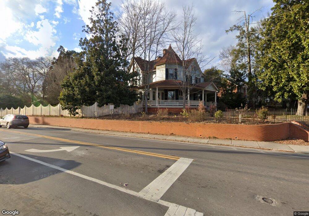
490 S Milledge Ave Athens, GA 30605
Milledge Avenue Historic District NeighborhoodEstimated Value: $1,667,000 - $2,274,798
--
Bed
--
Bath
4,786
Sq Ft
$392/Sq Ft
Est. Value
About This Home
This home is located at 490 S Milledge Ave, Athens, GA 30605 and is currently estimated at $1,876,599, approximately $392 per square foot. 490 S Milledge Ave is a home located in Clarke County with nearby schools including Bettye Henderson Holston Elementary School, Clarke Middle School, and Clarke Central High School.
Ownership History
Date
Name
Owned For
Owner Type
Purchase Details
Closed on
Aug 17, 2018
Sold by
Lewis Ward B
Bought by
Lewis Erika Cornehl and Ward B Lewis Jr Liv Trust
Current Estimated Value
Purchase Details
Closed on
Mar 1, 2001
Sold by
Lewis Ward B
Bought by
Lewis Ward B Jr Living Trust By Trusttee
Purchase Details
Closed on
Jul 9, 1990
Sold by
Lewis Ward B
Bought by
Lewis Ward B
Create a Home Valuation Report for This Property
The Home Valuation Report is an in-depth analysis detailing your home's value as well as a comparison with similar homes in the area
Home Values in the Area
Average Home Value in this Area
Purchase History
| Date | Buyer | Sale Price | Title Company |
|---|---|---|---|
| Lewis Erika Cornehl | -- | -- | |
| Lewis Ward B Jr Living Trust By Trusttee | -- | -- | |
| Lewis Ward B | -- | -- |
Source: Public Records
Tax History Compared to Growth
Tax History
| Year | Tax Paid | Tax Assessment Tax Assessment Total Assessment is a certain percentage of the fair market value that is determined by local assessors to be the total taxable value of land and additions on the property. | Land | Improvement |
|---|---|---|---|---|
| 2025 | $11,330 | $781,377 | $207,680 | $573,697 |
| 2024 | $11,330 | $724,182 | $207,680 | $516,502 |
| 2023 | $11,187 | $572,558 | $207,680 | $364,878 |
| 2022 | $7,987 | $414,620 | $181,720 | $232,900 |
| 2021 | $7,829 | $370,801 | $181,720 | $189,081 |
| 2020 | $7,339 | $349,498 | $181,720 | $167,778 |
| 2019 | $7,394 | $349,498 | $181,720 | $167,778 |
| 2018 | $7,394 | $346,978 | $179,200 | $167,778 |
| 2017 | $7,230 | $342,161 | $179,200 | $162,961 |
| 2016 | $7,128 | $339,150 | $179,200 | $159,950 |
| 2015 | $6,747 | $331,934 | $179,200 | $152,734 |
| 2014 | $6,820 | $334,073 | $179,200 | $154,873 |
Source: Public Records
Map
Nearby Homes
- 255 Bloomfield St
- 265 Springdale St
- 338 Springdale St
- 597 Dearing St
- 50 Springdale St
- 494 Baxter St Unit 32
- 365 S Church St Unit 1A, 1B, 1C
- 500 Dearing St Unit 6
- 1055 Baxter St Unit 504
- 1226 W Broad St
- 997 S Milledge Ave Unit 2
- 997 S Milledge Ave Unit 3
- 997 S Milledge Ave Unit 1
- 997 S Milledge Ave Unit 4
- 577 W Cloverhurst Ave
- 495 Woodlawn Ave
- 1198 W West Hancock Ave W
- 1196 W Hancock Ave Unit 1
- 1398 W Hancock Ave
- 206 Fortson Dr
- 500 S Milledge Ave
- 480 S Milledge Ave Unit D4
- 480 S Milledge Ave
- 480 S Milledge Ave Unit B4
- 480 S Milledge Ave
- 480 S Milledge Ave Unit A2
- 920 Baxter St
- 530 S Milledge Ave
- 440 S Milledge Ave
- 495 S Milledge Ave Unit A-1
- 495 S Milledge Ave
- 420 S Milledge Ave
- 545 S Milledge Ave
- 810 Baxter St Unit B-2
- 810 Baxter St Unit D-1
- 810 Baxter St
- 540 S Milledge Ave Unit 4
- 540 S Milledge Ave Unit 3
- 540 S Milledge Ave Unit 2
- 540 S Milledge Ave Unit 1