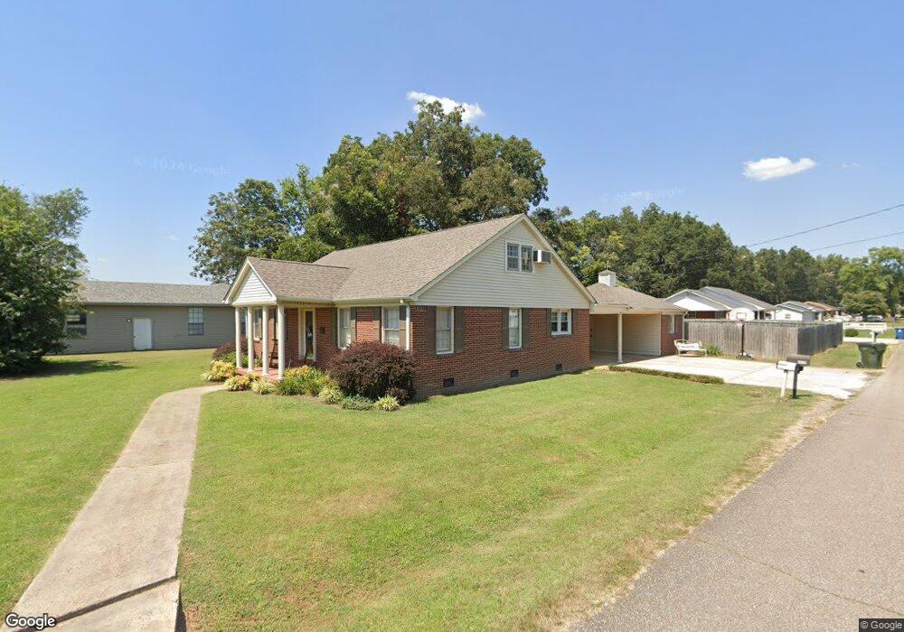
4900 Highway 104 W Dyersburg, TN 38024
Estimated Value: $180,377 - $308,000
--
Bed
2
Baths
1,827
Sq Ft
$126/Sq Ft
Est. Value
About This Home
This home is located at 4900 Highway 104 W, Dyersburg, TN 38024 and is currently estimated at $230,594, approximately $126 per square foot. 4900 Highway 104 W is a home located in Dyer County with nearby schools including Finley Elementary School, Three Oaks Middle School, and Dyer County High School.
Ownership History
Date
Name
Owned For
Owner Type
Purchase Details
Closed on
Oct 7, 2013
Sold by
Boatright Tommy E
Bought by
Boatright Eugenia
Current Estimated Value
Purchase Details
Closed on
Sep 27, 1999
Sold by
Guthrie John A and Guthrie Karen E
Bought by
Boatright Tommy E
Home Financials for this Owner
Home Financials are based on the most recent Mortgage that was taken out on this home.
Original Mortgage
$67,200
Interest Rate
7.79%
Purchase Details
Closed on
Oct 5, 1998
Sold by
Holt Harold
Bought by
Guthrie John A and Guthrie Karen E
Home Financials for this Owner
Home Financials are based on the most recent Mortgage that was taken out on this home.
Original Mortgage
$71,266
Interest Rate
6.8%
Purchase Details
Closed on
Jun 3, 1963
Bought by
Holt Harold and Holt Bonnie
Create a Home Valuation Report for This Property
The Home Valuation Report is an in-depth analysis detailing your home's value as well as a comparison with similar homes in the area
Home Values in the Area
Average Home Value in this Area
Purchase History
| Date | Buyer | Sale Price | Title Company |
|---|---|---|---|
| Boatright Eugenia | $84,000 | -- | |
| Boatright Tommy E | $84,000 | -- | |
| Guthrie John A | $70,000 | -- | |
| Holt Harold | -- | -- |
Source: Public Records
Mortgage History
| Date | Status | Borrower | Loan Amount |
|---|---|---|---|
| Previous Owner | Holt Harold | $67,200 | |
| Previous Owner | Holt Harold | $71,266 |
Source: Public Records
Tax History Compared to Growth
Tax History
| Year | Tax Paid | Tax Assessment Tax Assessment Total Assessment is a certain percentage of the fair market value that is determined by local assessors to be the total taxable value of land and additions on the property. | Land | Improvement |
|---|---|---|---|---|
| 2024 | $713 | $28,975 | $2,000 | $26,975 |
| 2023 | $713 | $28,975 | $2,000 | $26,975 |
| 2022 | $687 | $28,975 | $2,000 | $26,975 |
| 2021 | $687 | $28,975 | $2,000 | $26,975 |
| 2020 | $687 | $28,975 | $2,000 | $26,975 |
| 2019 | $700 | $26,475 | $2,000 | $24,475 |
| 2018 | $700 | $26,475 | $2,000 | $24,475 |
| 2017 | $700 | $26,475 | $2,000 | $24,475 |
| 2016 | $700 | $26,475 | $2,000 | $24,475 |
| 2015 | $662 | $26,475 | $2,000 | $24,475 |
| 2014 | $662 | $26,475 | $2,000 | $24,475 |
Source: Public Records
Map
Nearby Homes
- 64 Holt St
- 265 Benjamin Dr
- 285 Benjamin Dr
- 365 Benjamin Dr
- 20 Poplar St
- 4966 Upper Finley Rd
- 566 Simpson Rd
- 3765 Upper Finley Rd
- 213 5th Ave
- Lot 23 Deer Track Cove
- 819 Blake Cove
- Lot 37 Chickasaw Bluff Dr
- Lot 38 Chickasaw Bluff Dr
- 202 3rd Ave
- 433 Burgies Chapel Rd
- 983 Sir James Ave
- 2016 Forrest St
- 2409 Rambo Rd
- 1980 & 1970 Brewer Rd
- 76 Village St