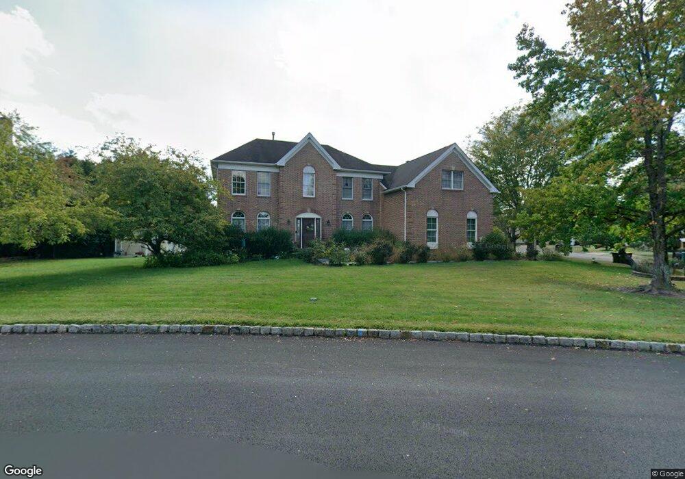
4905 Davis Dr Doylestown, PA 18902
Estimated Value: $838,633 - $915,000
4
Beds
3
Baths
3,018
Sq Ft
$293/Sq Ft
Est. Value
About This Home
This home is located at 4905 Davis Dr, Doylestown, PA 18902 and is currently estimated at $883,658, approximately $292 per square foot. 4905 Davis Dr is a home located in Bucks County with nearby schools including Cold Spring Elementary School, Holicong Middle School, and Central Bucks High School - East.
Ownership History
Date
Name
Owned For
Owner Type
Purchase Details
Closed on
Jan 24, 1995
Sold by
Cold Spring Hunt L P
Bought by
Taylor Steven P and Taylor Ruth C
Current Estimated Value
Home Financials for this Owner
Home Financials are based on the most recent Mortgage that was taken out on this home.
Original Mortgage
$226,950
Interest Rate
9.13%
Create a Home Valuation Report for This Property
The Home Valuation Report is an in-depth analysis detailing your home's value as well as a comparison with similar homes in the area
Home Values in the Area
Average Home Value in this Area
Purchase History
| Date | Buyer | Sale Price | Title Company |
|---|---|---|---|
| Taylor Steven P | $283,696 | -- |
Source: Public Records
Mortgage History
| Date | Status | Borrower | Loan Amount |
|---|---|---|---|
| Closed | Taylor Steven P | $226,950 |
Source: Public Records
Tax History
| Year | Tax Paid | Tax Assessment Tax Assessment Total Assessment is a certain percentage of the fair market value that is determined by local assessors to be the total taxable value of land and additions on the property. | Land | Improvement |
|---|---|---|---|---|
| 2025 | $8,533 | $52,410 | $10,760 | $41,650 |
| 2024 | $8,533 | $52,410 | $10,760 | $41,650 |
| 2023 | $8,244 | $52,410 | $10,760 | $41,650 |
| 2022 | $8,145 | $52,410 | $10,760 | $41,650 |
| 2021 | $8,048 | $52,410 | $10,760 | $41,650 |
| 2020 | $8,048 | $52,410 | $10,760 | $41,650 |
| 2019 | $7,995 | $52,410 | $10,760 | $41,650 |
| 2018 | $7,995 | $52,410 | $10,760 | $41,650 |
| 2017 | $7,930 | $52,410 | $10,760 | $41,650 |
| 2016 | $8,008 | $52,410 | $10,760 | $41,650 |
| 2015 | -- | $52,410 | $10,760 | $41,650 |
| 2014 | -- | $57,040 | $10,760 | $46,280 |
Source: Public Records
Map
Nearby Homes
- 3960 S Mallard Ln
- 4533 Deep Creek Way
- 4179 Miladies Ln
- 4783 Landisville Rd
- 5087 Raintree Ct
- 3689 Hancock Ln
- 4745 Nottingham Way
- 5491 Long Ln
- 3468 Holicong Rd
- 4990 Point Pleasant Pike
- 5182 Point Pleasant Pike
- 6680 Point Pleasant Pike
- 5380 Point Pleasant Pike
- 30 John Dyer Way
- 4215 Ferguson Dr
- 5829 Ridgeview Dr
- 5805 Ridgeview Dr
- 3039 Durham Rd
- 6185 Mechanicsville Rd
- 4306 Kleinot Dr
- 43 Jacob Stout Rd
- 3 Plough Tavern Rd
- 5 Plough Tavern Rd
- 4 Plough Tavern Rd
- 0 Owls Nest Ln Unit 6626526
- 0 Owls Nest Ln Unit 6621517
- 4088 Pierce Ln
- 4900 Davis Dr
- 4910 Davis Dr
- 4918 Davis Dr
- 4892 Davis Dr
- 4082 Pierce Ln
- 4089 Pierce Ln
- 4882 Davis Dr
- 4928 Davis Dr
- 4078 Pierce Ln
- 4885 Redfield Rd
- 4937 Davis Dr
- 4875 Redfield Rd
- 4895 Redfield Rd
Your Personal Tour Guide
Ask me questions while you tour the home.