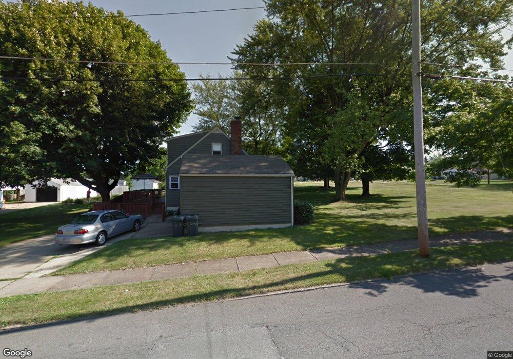
4907 Sheridan Rd Youngstown, OH 44514
Estimated Value: $147,135 - $163,000
4
Beds
2
Baths
1,491
Sq Ft
$105/Sq Ft
Est. Value
About This Home
This home is located at 4907 Sheridan Rd, Youngstown, OH 44514 and is currently estimated at $156,034, approximately $104 per square foot. 4907 Sheridan Rd is a home located in Mahoning County with nearby schools including Darwin L. Gilmore Elementary School, Paul C. Bunn Elementary School, and Bayside Intermediate School.
Ownership History
Date
Name
Owned For
Owner Type
Purchase Details
Closed on
Nov 13, 2019
Sold by
Travers Christopher N and Dougan Patricia
Bought by
Travers Christopher N and Dougan Patricia
Current Estimated Value
Purchase Details
Closed on
Feb 27, 2004
Sold by
Miller John T
Bought by
Miller John T and Miller John T
Purchase Details
Closed on
Mar 31, 2000
Bought by
Christopher N Travers
Purchase Details
Closed on
Jun 1, 1999
Sold by
Partezana Dominic and Partezana Helena C
Bought by
Miller John T
Purchase Details
Closed on
Jan 1, 1990
Bought by
Partezana Partezana H and Partezana D
Create a Home Valuation Report for This Property
The Home Valuation Report is an in-depth analysis detailing your home's value as well as a comparison with similar homes in the area
Home Values in the Area
Average Home Value in this Area
Purchase History
| Date | Buyer | Sale Price | Title Company |
|---|---|---|---|
| Travers Christopher N | -- | None Available | |
| Miller John T | -- | -- | |
| Christopher N Travers | -- | -- | |
| Miller John T | $69,900 | -- | |
| Partezana Partezana H | -- | -- |
Source: Public Records
Mortgage History
| Date | Status | Borrower | Loan Amount |
|---|---|---|---|
| Closed | Miller John T | $0 |
Source: Public Records
Tax History Compared to Growth
Tax History
| Year | Tax Paid | Tax Assessment Tax Assessment Total Assessment is a certain percentage of the fair market value that is determined by local assessors to be the total taxable value of land and additions on the property. | Land | Improvement |
|---|---|---|---|---|
| 2024 | $1,670 | $35,100 | $3,330 | $31,770 |
| 2023 | $1,658 | $35,100 | $3,330 | $31,770 |
| 2022 | $1,276 | $20,790 | $3,430 | $17,360 |
| 2021 | $1,276 | $20,790 | $3,430 | $17,360 |
| 2020 | $1,284 | $20,790 | $3,430 | $17,360 |
| 2019 | $1,278 | $18,560 | $3,060 | $15,500 |
| 2018 | $1,290 | $18,560 | $3,060 | $15,500 |
| 2017 | $1,287 | $18,560 | $3,060 | $15,500 |
| 2016 | $1,366 | $21,200 | $3,060 | $18,140 |
| 2015 | $1,338 | $21,200 | $3,060 | $18,140 |
| 2014 | $1,328 | $21,200 | $3,060 | $18,140 |
| 2013 | $1,309 | $21,200 | $3,060 | $18,140 |
Source: Public Records
Map
Nearby Homes
- 1913 Country Club Ave
- 1645 Chattanooga Ave
- 1720 Sequoya Dr
- 0 Lemoyne Ave
- 2002 Bancroft Ave
- 1543 Lynn Ave
- 1933 Brandon Ave
- 1661 Wakefield Ave
- 1633 Wakefield Ave
- 1514 Thalia Ave
- 1553 Bancroft Ave
- 1828 Basil Ave
- 2001 Brownlee Ave
- 1579 Wakefield Ave
- 608 Maplewood Ave
- 1830 Halbert Dr
- 1513 Wakefield Ave
- 1919 Wingate Rd
- 0 Weston Ave
- 576 W Harvey St
- 4917 Sheridan Rd
- 1917 Thalia Ave
- 4827 Sheridan Rd
- 1923 Thalia Ave
- 1927 Thalia Ave
- 4927 Sheridan Rd
- 1916 Thalia Ave
- 4908 Sheridan Rd
- 4817 Sheridan Rd
- 1931 Thalia Ave
- 1924 Country Club Ave
- 1920 Thalia Ave
- 1928 Country Club Ave
- 4828 Sheridan Rd
- 1935 Thalia Ave
- 1924 Thalia Ave
- 4928 Sheridan Rd
- 1932 Country Club Ave
- 1681 Thalia Ave
- 1917 Lynn Ave