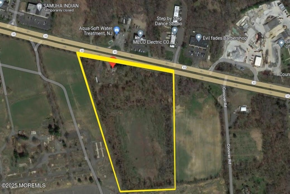
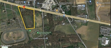
491 State Route 33 Millstone Township, NJ 08535
Estimated payment $84,858/month
About This Lot
Great opportunity in Monmouth County!rnLocated in the heart of Central New Jersey, right on Route 33, Millstone in PCD Zone. Potential CLASS ''A'' Industrial Park 3000,000+ GFS Building, 5+ Bay Doors, 36ft cl height ceilings.rn- Just 6 miles fom Exit 8 from NJ Tpkern- 7.5 miles to Route 130rn- 16 miles to Route 1 & I-195rn- Less than 50 minutes fron Newark Airport.rn- 45 miles to Port Elizabeth, Newark, NJrn- 51 miles to Philadelphiarn- 1 million + Class ''A'' Industrial Park next door.
Property Details
Property Type
- Land
Est. Annual Taxes
- $6,344
Home Design
- 2,000 Sq Ft Home
Schools
- Millstone Elementary And Middle School
Utilities
- Well
- Septic Needed
Additional Features
- Electricity Available at Street
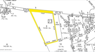
- 14.85 Acre Lot
Listing and Financial Details
- Assessor Parcel Number 33-00023-0000-00009
Map
Home Values in the Area
Average Home Value in this Area
Tax History
| Year | Tax Paid | Tax Assessment Tax Assessment Total Assessment is a certain percentage of the fair market value that is determined by local assessors to be the total taxable value of land and additions on the property. | Land | Improvement |
|---|---|---|---|---|
| 2025 | $6,344 | $425,200 | $111,600 | $313,600 |
| 2024 | $6,583 | $264,900 | $220,000 | $44,900 |
| 2023 | $6,583 | $264,900 | $220,000 | $44,900 |
| 2022 | $6,267 | $264,900 | $220,000 | $44,900 |
| 2021 | $6,267 | $264,900 | $220,000 | $44,900 |
| 2020 | $3,435 | $143,900 | $99,000 | $44,900 |
| 2019 | $3,370 | $143,900 | $99,000 | $44,900 |
| 2018 | $3,287 | $143,900 | $99,000 | $44,900 |
| 2017 | $3,272 | $143,900 | $99,000 | $44,900 |
| 2016 | $3,532 | $156,500 | $99,000 | $57,500 |
| 2015 | $3,582 | $150,900 | $99,000 | $51,900 |
| 2014 | $3,608 | $138,700 | $92,000 | $46,700 |
Property History
| Date | Event | Price | List to Sale | Price per Sq Ft |
|---|---|---|---|---|
| 03/12/2025 03/12/25 | For Sale | $16,000,000 | -- | $8,000 / Sq Ft |
Source: MOREMLS (Monmouth Ocean Regional REALTORS®)
MLS Number: 22506793
APN: 33-00023-0000-00009
Disclaimer: Certain information contained herein is derived from information provided by parties other than Homes.com. All information provided is deemed reliable, but is not guaranteed to be accurate and should be independently verified.
![]() IDX information is provided exclusively for personal, non-commercial use, and may not be used for any purpose other than to identify prospective properties consumers may be interested in purchasing.
IDX information is provided exclusively for personal, non-commercial use, and may not be used for any purpose other than to identify prospective properties consumers may be interested in purchasing.
Information is deemed reliable but not guaranteed.
- 85 Mustang Dr
- 594 Saint Andrews Place
- 410 Saint Andrews Place Unit 2212
- 614 Fremont Dr
- 163 Shinnecock Dr
- 100 Anderson
- 216 Woodward Rd
- 21 Lasatta Ave
- 626 Marion Ln
- 301 Matutina Rd
- 80 Butcher Rd
- 16 Clover Ln
- 1000 Justin Way
- 30 Clover Ln
- 1905 John Deere Ln
- 1704 Hights Farm Rd S
- 1101 Hights Farm Rd N
- 39 Periwinkle Dr Unit 9
- 1 John Adams Ct Unit B
- 26 James Buchanan Dr Unit 26D
