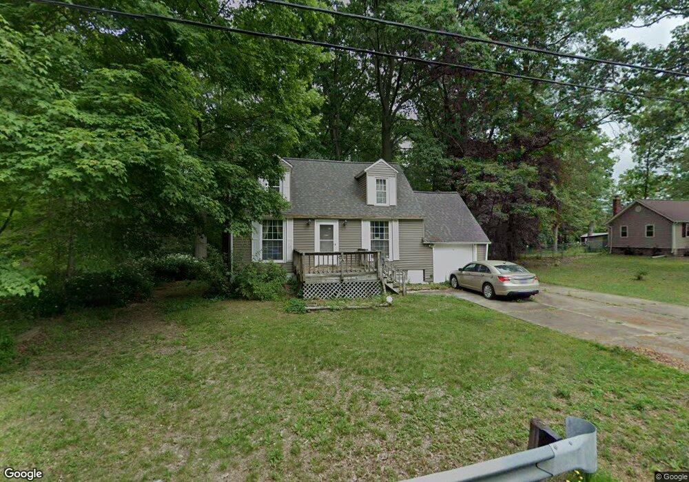
4919 Harding Ave Ravenna, OH 44266
Estimated Value: $145,843 - $210,000
3
Beds
1
Bath
1,089
Sq Ft
$168/Sq Ft
Est. Value
About This Home
This home is located at 4919 Harding Ave, Ravenna, OH 44266 and is currently estimated at $182,711, approximately $167 per square foot. 4919 Harding Ave is a home located in Portage County with nearby schools including West Park Elementary School, Brown Middle School, and Ravenna High School.
Ownership History
Date
Name
Owned For
Owner Type
Purchase Details
Closed on
Mar 3, 2025
Sold by
Portage County
Bought by
Moon Gregory D and Moon Teresa M
Current Estimated Value
Purchase Details
Closed on
Sep 29, 2006
Sold by
Arbaugh Dennis M and Arbaugh Margaret A
Bought by
Schultz Gary M and Richards Frank J
Home Financials for this Owner
Home Financials are based on the most recent Mortgage that was taken out on this home.
Original Mortgage
$109,900
Interest Rate
6.5%
Mortgage Type
Stand Alone First
Purchase Details
Closed on
Apr 29, 1994
Bought by
Arbaugh Dennis M
Create a Home Valuation Report for This Property
The Home Valuation Report is an in-depth analysis detailing your home's value as well as a comparison with similar homes in the area
Home Values in the Area
Average Home Value in this Area
Purchase History
| Date | Buyer | Sale Price | Title Company |
|---|---|---|---|
| Moon Gregory D | $93,334 | None Listed On Document | |
| Schultz Gary M | $109,900 | First American Title Ins Co | |
| Arbaugh Dennis M | $40,000 | -- |
Source: Public Records
Mortgage History
| Date | Status | Borrower | Loan Amount |
|---|---|---|---|
| Previous Owner | Schultz Gary M | $109,900 |
Source: Public Records
Tax History Compared to Growth
Tax History
| Year | Tax Paid | Tax Assessment Tax Assessment Total Assessment is a certain percentage of the fair market value that is determined by local assessors to be the total taxable value of land and additions on the property. | Land | Improvement |
|---|---|---|---|---|
| 2024 | $2,109 | $45,790 | $5,990 | $39,800 |
| 2023 | $1,690 | $30,910 | $5,010 | $25,900 |
| 2022 | $1,669 | $30,910 | $5,010 | $25,900 |
| 2021 | $1,615 | $30,910 | $5,010 | $25,900 |
| 2020 | $1,575 | $26,610 | $5,010 | $21,600 |
| 2019 | $1,568 | $26,610 | $5,010 | $21,600 |
| 2018 | $1,469 | $23,880 | $5,360 | $18,520 |
| 2017 | $1,469 | $23,880 | $5,360 | $18,520 |
| 2016 | $1,345 | $23,880 | $5,360 | $18,520 |
| 2015 | $1,347 | $23,880 | $5,360 | $18,520 |
| 2014 | $1,352 | $23,880 | $5,360 | $18,520 |
| 2013 | $1,344 | $23,880 | $5,360 | $18,520 |
Source: Public Records
Map
Nearby Homes
- 6235 Gladys St Unit 4
- 1347 Harding Ave Unit 7A
- 6442 Peck Rd
- 6590 Peck Rd
- 6600 Peck Rd
- 324 Maple St
- 377 Maple St
- 250 Lawrence St
- 241 Myrtle St
- 4852 Lovers Ln
- 519 Tappan Ct
- 5601 Newton Falls Rd
- 5659 State Route 14
- 451 Pratt St
- 0 Bronco Rd
- 7017 Peck Rd
- 450 S Walnut St
- 537 Ohio Ave
- 159 E Harris Ave
- 242 W Highland Ave
- 4931 Harding Ave
- 4907 Harding Ave
- 4942 Harding Ave
- 4918 Harding Ave
- 4943 Harding Ave
- 6312 Ferndale Rd
- 4895 Harding Ave
- V/L Ferndale St
- 0 Ferndale St
- 4956 Harding Ave
- 4894 Harding Ave
- 4953 Harding Ave
- 4887 Harding Ave
- 6322 Ferndale Rd
- 6245 Glenwood St
- 6309 Peck Rd
- 4890 Harding Ave
- 9999 Woodbine Rd
- 4871 Harding Ave
- 6332 Ferndale Rd