Estimated Value: $78,291 - $196,000
Studio
--
Bath
1,008
Sq Ft
$135/Sq Ft
Est. Value
About This Home
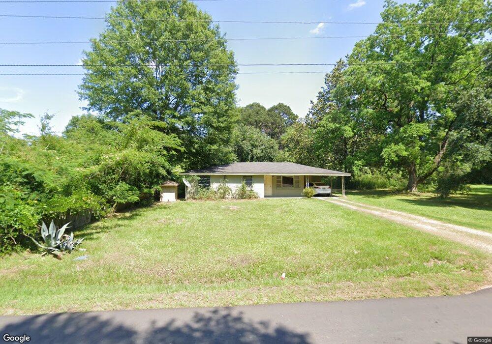
This home is located at 492 Batson Rd, Petal, MS 39465 and is currently estimated at $135,823, approximately $134 per square foot. 492 Batson Rd is a home located in Forrest County with nearby schools including Petal Primary School, Petal Elementary School, and Petal Upper Elementary School.
Ownership History
Date
Name
Owned For
Owner Type
Purchase Details
Closed on
Jun 14, 2023
Sold by
Cooleys Rental Llc
Bought by
Tranquilino Francisco and Morgan Tiffany
Current Estimated Value
Purchase Details
Closed on
Sep 14, 2021
Sold by
Cooleys Rental Llc
Bought by
Scranage Paul
Home Financials for this Owner
Home Financials are based on the most recent Mortgage that was taken out on this home.
Original Mortgage
$116,161
Interest Rate
2.7%
Mortgage Type
New Conventional
Purchase Details
Closed on
Apr 8, 2010
Sold by
Reid Eron C and Reid Anna L
Bought by
Cooleys Rental Llc
Create a Home Valuation Report for This Property
The Home Valuation Report is an in-depth analysis detailing your home's value as well as a comparison with similar homes in the area
Purchase History
| Date | Buyer | Sale Price | Title Company |
|---|---|---|---|
| Tranquilino Francisco | -- | None Listed On Document | |
| Scranage Paul | -- | Deep South Title | |
| Cooleys Rental Llc | -- | -- |
Source: Public Records
Mortgage History
| Date | Status | Borrower | Loan Amount |
|---|---|---|---|
| Previous Owner | Scranage Paul | $116,161 |
Source: Public Records
Tax History
| Year | Tax Paid | Tax Assessment Tax Assessment Total Assessment is a certain percentage of the fair market value that is determined by local assessors to be the total taxable value of land and additions on the property. | Land | Improvement |
|---|---|---|---|---|
| 2024 | $647 | $4,467 | $0 | $0 |
| 2023 | $588 | $29,780 | $0 | $0 |
| 2022 | $566 | $4,467 | $0 | $0 |
| 2021 | $569 | $4,467 | $0 | $0 |
| 2020 | $563 | $4,383 | $0 | $0 |
| 2019 | $562 | $4,383 | $0 | $0 |
| 2018 | $563 | $4,383 | $0 | $0 |
| 2017 | $571 | $4,383 | $0 | $0 |
| 2016 | $550 | $4,242 | $0 | $0 |
| 2015 | $539 | $4,242 | $0 | $0 |
| 2014 | $529 | $4,242 | $0 | $0 |
Source: Public Records
Map
Nearby Homes
- 41 Forest Barnes Rd
- 151 Baker St
- 15 Stonemore Rd
- 26 Stonemore Rd
- 32 Stonemore Rd
- 13 Grand Cove
- 6 Grand Cove
- 88 Sunline Dr
- 91 Sunline Dr
- 2 Grand Cove
- 152 Sunline Dr
- 12 Stonemore Rd
- 69 Sunline Dr
- 24 Rotan Ct
- 189 Sunline Dr
- 19 Thomford Way
- 1424 Carterville Rd
- 118 van Slyke Ln
- 96 High Meadows Cir
- 92 High Meadows Cir
- 484 Batson Rd
- 521 E Fifth Ave
- 13 Sunrise Heights
- 29 Sunrise Heights
- 35 Sunrise Heights
- 473 Batson Rd
- 39 Sunrise Rd
- 36 Sunrise Heights
- 532 Batson Rd
- 540 Batson Rd
- 536 Batson Rd
- 284 Sunrise Rd
- 1035 Luther Carter Rd
- 515 Batson Rd
- 1052 Luther Carter Rd
- 279 Sunrise Rd
- 261 Sunrise Rd
- 1042 Luther Carter Rd
- 268 Sunrise Rd
- 285 Sunrise Rd
Your Personal Tour Guide
Ask me questions while you tour the home.