Estimated Value: $126,241 - $232,000
2
Beds
2
Baths
1,232
Sq Ft
$146/Sq Ft
Est. Value
About This Home
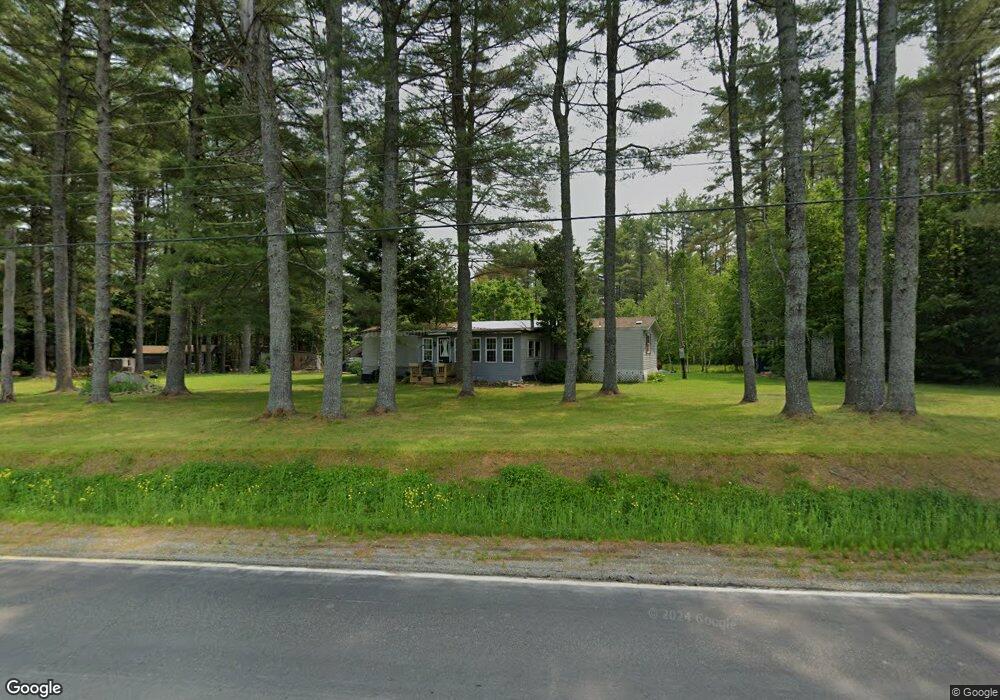
This home is located at 492 Valley Rd, Anson, ME 04911 and is currently estimated at $179,560, approximately $145 per square foot. 492 Valley Rd is a home located in Somerset County.
Ownership History
Date
Name
Owned For
Owner Type
Purchase Details
Closed on
Oct 9, 2013
Sold by
Bussard Jean N P Est
Bought by
Paine Cathie L
Current Estimated Value
Purchase Details
Closed on
Aug 16, 2013
Sold by
Anson Town Of
Bought by
Paine John W and Paine Cathie L
Purchase Details
Closed on
Jun 4, 2013
Sold by
Anson Town Of
Bought by
Paine John W and Paine Cathie L
Purchase Details
Closed on
Feb 18, 2010
Sold by
Bussard Paine Jean N Est
Bought by
Paine John W and Paine Cathie L
Purchase Details
Closed on
Jun 21, 2007
Sold by
Paine John W and Paine Cathie L
Bought by
Bussard Jean N P
Create a Home Valuation Report for This Property
The Home Valuation Report is an in-depth analysis detailing your home's value as well as a comparison with similar homes in the area
Home Values in the Area
Average Home Value in this Area
Purchase History
| Date | Buyer | Sale Price | Title Company |
|---|---|---|---|
| Paine Cathie L | -- | -- | |
| Paine John W | -- | -- | |
| Paine John W | -- | -- | |
| Paine John W | -- | -- | |
| Bussard Jean N P | -- | -- |
Source: Public Records
Tax History
| Year | Tax Paid | Tax Assessment Tax Assessment Total Assessment is a certain percentage of the fair market value that is determined by local assessors to be the total taxable value of land and additions on the property. | Land | Improvement |
|---|---|---|---|---|
| 2025 | $1,510 | $81,730 | $32,890 | $48,840 |
| 2024 | $1,340 | $81,730 | $32,890 | $48,840 |
| 2023 | $1,168 | $61,450 | $24,730 | $36,720 |
| 2022 | $1,106 | $61,450 | $24,730 | $36,720 |
| 2021 | $1,109 | $53,430 | $21,500 | $31,930 |
| 2020 | $1,189 | $53,430 | $21,500 | $31,930 |
| 2019 | $1,175 | $53,430 | $21,500 | $31,930 |
| 2018 | $1,120 | $53,430 | $21,500 | $31,930 |
| 2017 | $1,069 | $53,430 | $21,500 | $31,930 |
| 2016 | $1,010 | $53,430 | $21,500 | $31,930 |
| 2015 | $1,069 | $53,430 | $21,500 | $31,930 |
| 2014 | $1,069 | $53,430 | $21,500 | $31,930 |
| 2013 | -- | $53,430 | $21,500 | $31,930 |
Source: Public Records
Map
Nearby Homes
- 562 Valley Rd
- 167 (House) Town Farm Rd
- 167 Town Farm Rd
- 167 Rd
- 47 New Portland Rd
- 215 Embden Pond Rd
- 705 Hollin Waite Hill Rd
- 35 Hall St
- 565 River Rd
- 1 Katie Crotch Rd
- 20 Blue Jay Dr
- 142 River Rd
- 205 Greenleaf Rd
- 047-025 Cardinal Dr
- 98 Madison Ave
- 95 Main St
- 75 Madison Ave
- 51 Maple St
- 21 School St
- Lot 36 Wedge St
- 492 Valley Rd
- 504 Valley Rd
- 476 Valley Rd
- 476 Valley Rd
- 0 Maine 234
- 796 Horseback Rd
- 562 Valley Rd
- 584 Valley Rd
- 847 Horseback Rd
- 567 Valley Rd
- 822 Horseback Rd
- 812 Horseback Rd
- 587 Valley Rd
- 0 Town Farm Rd
- TBD Town Farm Rd
- 790 Horseback Rd
- 807 Horseback Rd
- 30 Joyville Ln
- 596 Valley Rd
- 793 Horseback Rd
Your Personal Tour Guide
Ask me questions while you tour the home.