Estimated Value: $264,838 - $316,000
3
Beds
1
Bath
1,587
Sq Ft
$185/Sq Ft
Est. Value
About This Home
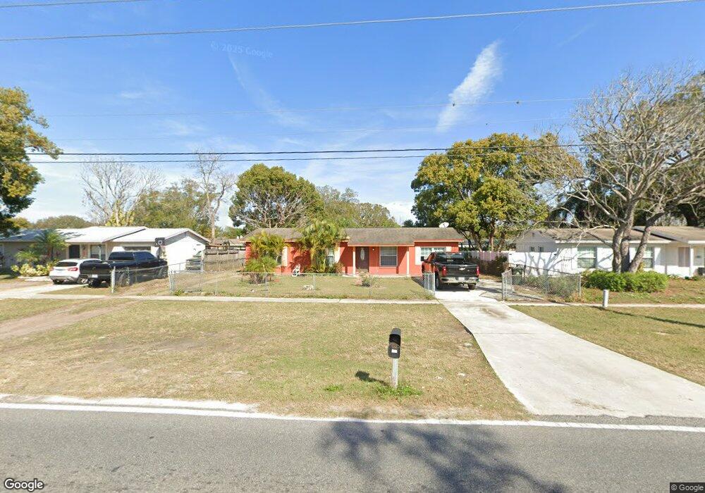
This home is located at 492 Wurst Rd, Ocoee, FL 34761 and is currently estimated at $293,710, approximately $185 per square foot. 492 Wurst Rd is a home located in Orange County with nearby schools including Spring Lake Elementary School, Ocoee Middle School, and Ocoee High School.
Ownership History
Date
Name
Owned For
Owner Type
Purchase Details
Closed on
Nov 12, 2023
Sold by
Chavez Jose
Bought by
Vj Inversiones Llc
Current Estimated Value
Purchase Details
Closed on
Jun 2, 2015
Sold by
U S Bank National Association
Bought by
Chaves Jose
Purchase Details
Closed on
Feb 24, 2015
Sold by
Price John E and Price Johnathan
Bought by
U S Bank National Association
Purchase Details
Closed on
Feb 12, 1999
Sold by
Natran Inc
Bought by
Price John E
Purchase Details
Closed on
Aug 18, 1998
Sold by
Glendale Federal Banks Fsb
Bought by
Sec Of Hud
Purchase Details
Closed on
Jul 30, 1998
Sold by
Clerk Of The Court
Bought by
Glendale Federal Bank Fsb
Create a Home Valuation Report for This Property
The Home Valuation Report is an in-depth analysis detailing your home's value as well as a comparison with similar homes in the area
Home Values in the Area
Average Home Value in this Area
Purchase History
| Date | Buyer | Sale Price | Title Company |
|---|---|---|---|
| Vj Inversiones Llc | $100 | None Listed On Document | |
| Chaves Jose | $48,500 | None Available | |
| U S Bank National Association | $57,100 | None Available | |
| Price John E | $69,900 | -- | |
| Sec Of Hud | -- | -- | |
| Glendale Federal Bank Fsb | $100 | -- |
Source: Public Records
Mortgage History
| Date | Status | Borrower | Loan Amount |
|---|---|---|---|
| Closed | Glendale Federal Bank Fsb | $0 | |
| Closed | Glendale Federal Bank Fsb | $3,500 |
Source: Public Records
Tax History
| Year | Tax Paid | Tax Assessment Tax Assessment Total Assessment is a certain percentage of the fair market value that is determined by local assessors to be the total taxable value of land and additions on the property. | Land | Improvement |
|---|---|---|---|---|
| 2025 | $3,897 | $198,210 | $80,000 | $118,210 |
| 2024 | $3,260 | $192,680 | $80,000 | $112,680 |
| 2023 | $3,260 | $210,545 | $80,000 | $130,545 |
| 2022 | $3,018 | $194,186 | $80,000 | $114,186 |
| 2021 | $2,802 | $170,084 | $70,000 | $100,084 |
| 2020 | $2,454 | $145,867 | $45,000 | $100,867 |
| 2019 | $2,472 | $141,650 | $40,000 | $101,650 |
| 2018 | $2,292 | $124,181 | $29,000 | $95,181 |
| 2017 | $2,015 | $93,839 | $24,000 | $69,839 |
| 2016 | $1,820 | $72,974 | $15,000 | $57,974 |
| 2015 | $1,573 | $65,343 | $15,000 | $50,343 |
| 2014 | $1,411 | $52,017 | $15,000 | $37,017 |
Source: Public Records
Map
Nearby Homes
- 601 Catwood Dr
- 1500 Adair St
- 1602 Starfire Ln
- 1213 Baranova Rd
- 905 Spring Creek Dr
- 1514 Lady Ave
- 1614 Maureen Ave Unit 4
- 1102 Bellini Ln
- 1236 Russell Dr
- 314 Wurst Rd
- 314 15th Ave
- 1100 Malcom Rd
- 212 Audrey St
- 702 Carmen Dr
- 2009 Adair St
- 1103 Malcom Rd Unit 2
- 632 Cardinal St
- 800 Nicole Blvd
- 1079 N Lakewood Ave
- 902 Nicole Blvd
Your Personal Tour Guide
Ask me questions while you tour the home.