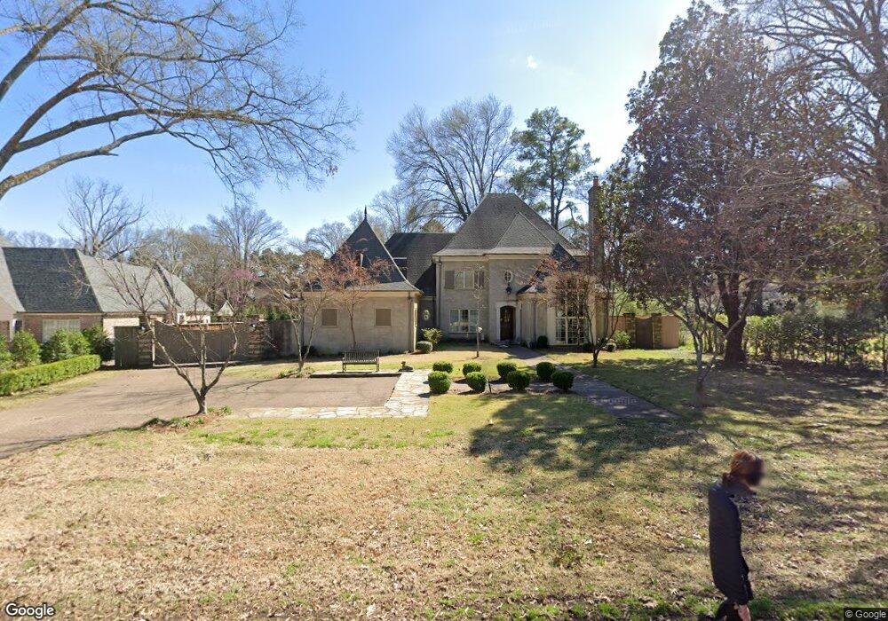
4925 Roane Rd Memphis, TN 38117
East Memphis NeighborhoodEstimated Value: $1,296,525 - $1,654,000
5
Beds
6
Baths
5,452
Sq Ft
$278/Sq Ft
Est. Value
About This Home
This home is located at 4925 Roane Rd, Memphis, TN 38117 and is currently estimated at $1,516,131, approximately $278 per square foot. 4925 Roane Rd is a home located in Shelby County with nearby schools including White Station Elementary School, White Station High, and White Station Middle.
Ownership History
Date
Name
Owned For
Owner Type
Purchase Details
Closed on
Aug 28, 2007
Sold by
Chickasaw Homes Inc
Bought by
Hanlon Steven G
Current Estimated Value
Home Financials for this Owner
Home Financials are based on the most recent Mortgage that was taken out on this home.
Original Mortgage
$630,000
Outstanding Balance
$392,281
Interest Rate
6.25%
Mortgage Type
New Conventional
Estimated Equity
$1,123,850
Purchase Details
Closed on
Mar 24, 2006
Sold by
Smith Robert Kuhen and Smith Deborah F
Bought by
Chickasaw Homes Inc
Home Financials for this Owner
Home Financials are based on the most recent Mortgage that was taken out on this home.
Original Mortgage
$862,500
Interest Rate
6.25%
Mortgage Type
Construction
Create a Home Valuation Report for This Property
The Home Valuation Report is an in-depth analysis detailing your home's value as well as a comparison with similar homes in the area
Home Values in the Area
Average Home Value in this Area
Purchase History
We collect this data history from publicly available records. To have your information removed, we recommend requesting removal directly through your county’s website.
| Date | Buyer | Sale Price | Title Company |
|---|---|---|---|
| Hanlon Steven G | $930,000 | None Available | |
| Chickasaw Homes Inc | $265,000 | None Available |
Source: Public Records
Mortgage History
We collect this data history from publicly available records. To have your information removed, we recommend requesting removal directly through your county’s website.
| Date | Status | Borrower | Loan Amount |
|---|---|---|---|
| Open | Hanlon Steven G | $630,000 | |
| Previous Owner | Chickasaw Homes Inc | $862,500 |
Source: Public Records
Tax History
| Year | Tax Paid | Tax Assessment Tax Assessment Total Assessment is a certain percentage of the fair market value that is determined by local assessors to be the total taxable value of land and additions on the property. | Land | Improvement |
|---|---|---|---|---|
| 2025 | -- | $393,675 | $51,275 | $342,400 |
| 2024 | -- | $294,075 | $38,250 | $255,825 |
| 2023 | $17,914 | $294,075 | $38,250 | $255,825 |
| 2022 | $17,914 | $294,075 | $38,250 | $255,825 |
| 2021 | $18,124 | $294,075 | $38,250 | $255,825 |
| 2020 | $19,146 | $264,225 | $38,250 | $225,975 |
| 2019 | $19,146 | $264,225 | $38,250 | $225,975 |
| 2018 | $19,146 | $264,225 | $38,250 | $225,975 |
| 2017 | $10,860 | $264,225 | $38,250 | $225,975 |
| 2016 | $10,674 | $244,250 | $0 | $0 |
Source: Public Records
Map
Nearby Homes
- 4910 Cole Rd
- 4898 Cole Rd
- 335 Clawson Cove
- 364 Clawson Cove
- 4792 Whitehall Cove
- 4779 Gwynne Rd
- 4749 Shady Grove Rd
- 353 Colonial Rd
- 400 Colonial Rd
- 4948 Fairfield Cir
- 4735 Mint Dr Unit 28C
- 4710 Gwynne Rd
- 474 Kingsgate Cove
- 4715 Mint Dr
- 480 Colonial Rd
- 500 Colonial Rd
- 365 Caraway Cove Unit 5A
- 468 Jack Kramer Dr
- 427 S Perkins Rd Unit 427-2
- 4640 Peppertree Ln
Your Personal Tour Guide
Ask me questions while you tour the home.