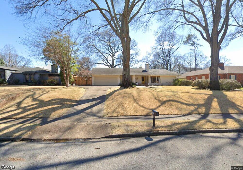
4927 Briarcliff Ave Memphis, TN 38117
Audubon Park NeighborhoodEstimated Value: $494,495 - $658,000
3
Beds
3
Baths
2,967
Sq Ft
$192/Sq Ft
Est. Value
About This Home
This home is located at 4927 Briarcliff Ave, Memphis, TN 38117 and is currently estimated at $570,374, approximately $192 per square foot. 4927 Briarcliff Ave is a home located in Shelby County with nearby schools including White Station Elementary School, White Station High, and White Station Middle.
Ownership History
Date
Name
Owned For
Owner Type
Purchase Details
Closed on
Jul 28, 2003
Sold by
Forrester M M and Forrester Lucy
Bought by
Ford Steven J and Ford Kathy R
Current Estimated Value
Home Financials for this Owner
Home Financials are based on the most recent Mortgage that was taken out on this home.
Original Mortgage
$275,900
Outstanding Balance
$119,724
Interest Rate
5.42%
Mortgage Type
Purchase Money Mortgage
Estimated Equity
$450,650
Create a Home Valuation Report for This Property
The Home Valuation Report is an in-depth analysis detailing your home's value as well as a comparison with similar homes in the area
Home Values in the Area
Average Home Value in this Area
Purchase History
| Date | Buyer | Sale Price | Title Company |
|---|---|---|---|
| Ford Steven J | $344,900 | -- |
Source: Public Records
Mortgage History
| Date | Status | Borrower | Loan Amount |
|---|---|---|---|
| Open | Ford Steven J | $275,900 |
Source: Public Records
Tax History Compared to Growth
Tax History
| Year | Tax Paid | Tax Assessment Tax Assessment Total Assessment is a certain percentage of the fair market value that is determined by local assessors to be the total taxable value of land and additions on the property. | Land | Improvement |
|---|---|---|---|---|
| 2025 | $3,304 | $126,975 | $44,425 | $82,550 |
| 2024 | $3,304 | $97,475 | $38,250 | $59,225 |
| 2023 | $5,938 | $97,475 | $38,250 | $59,225 |
| 2022 | $5,938 | $97,475 | $38,250 | $59,225 |
| 2021 | $6,007 | $97,475 | $38,250 | $59,225 |
| 2020 | $5,811 | $80,200 | $38,250 | $41,950 |
| 2019 | $5,811 | $80,200 | $38,250 | $41,950 |
| 2018 | $5,811 | $80,200 | $38,250 | $41,950 |
| 2017 | $3,296 | $80,200 | $38,250 | $41,950 |
| 2016 | $3,255 | $74,475 | $0 | $0 |
| 2014 | $3,255 | $74,475 | $0 | $0 |
Source: Public Records
Map
Nearby Homes
- 4859 Gwynne Rd
- 4772 Gwynne Rd
- 5071 Anchor Cove
- 4975 Brookwood Cove
- 5068 Walnut Grove Rd
- 267 Barry Rd
- 5055 Greenway Rd
- 5094 Cole Rd
- 50 Grove Creek Place
- 65 Laverne Ln
- 4916 Greenway Ave
- 4926 Greenway Ave
- 5157 S Angela Rd
- 356 Clove Dr
- 264 Barry Rd
- 4736 All Spice Dr Unit 71E
- 4679 Walnut Grove Rd
- 4903 Greenway Ave
- 4723 Normandy Ln
- 427 S Perkins Rd Unit 427-2
- 4939 Briarcliff Ave
- 4917 Briarcliff Ave
- 4930 Gwynne Rd
- 4949 Briarcliff Ave
- 4909 Briarcliff Ave
- 4916 Gwynne Rd
- 4938 Briarcliff Ave
- 4926 Briarcliff Ave
- 4916 Briarcliff Ave
- 4906 Gwynne Rd
- 4948 Briarcliff Ave
- 4959 Briarcliff Ave
- 4900 Briarcliff Ave
- 4950 Gwynne Rd
- 4894 Gwynne Rd
- 4885 Briarcliff Ave
- 4915 Lake Dr
- 75 S Mendenhall Rd
- 4967 Briarcliff Ave