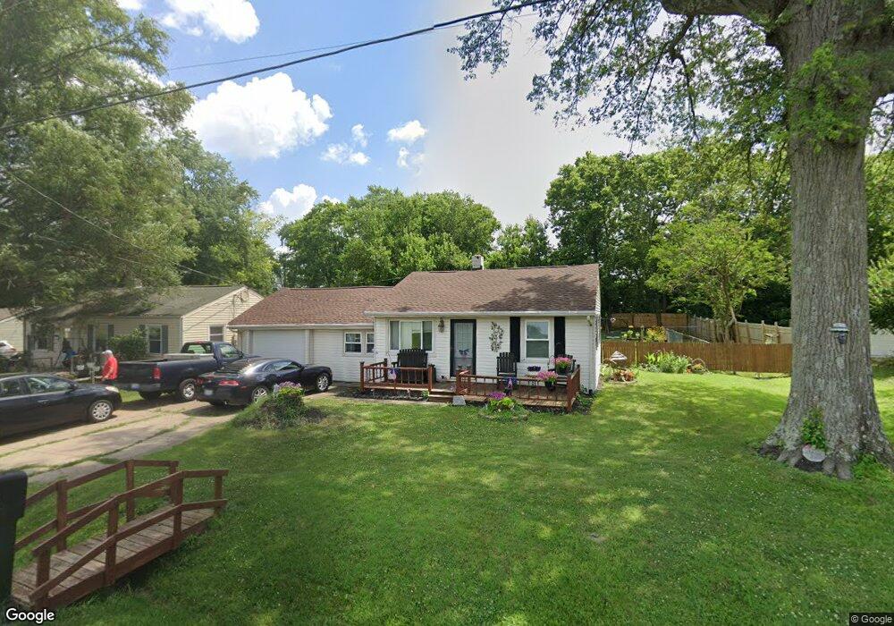
4928 Manchester Rd Franklin, OH 45005
Estimated Value: $152,919 - $168,000
2
Beds
1
Bath
624
Sq Ft
$256/Sq Ft
Est. Value
About This Home
This home is located at 4928 Manchester Rd, Franklin, OH 45005 and is currently estimated at $159,980, approximately $256 per square foot. 4928 Manchester Rd is a home located in Warren County with nearby schools including Franklin High School, St. John XXIII Catholic School, and Middletown Christian School.
Ownership History
Date
Name
Owned For
Owner Type
Purchase Details
Closed on
Jan 6, 1992
Sold by
Miller Ronald L and Miller Janal
Bought by
Hamilton and Hamilton Michael K
Current Estimated Value
Purchase Details
Closed on
Feb 28, 1991
Sold by
Takach Robert and Takach Patricia
Bought by
Miller and Miller Ronald L
Purchase Details
Closed on
Jun 30, 1986
Sold by
Hales Rodney G and Hales Cathy
Bought by
Takach and Takach Robert
Purchase Details
Closed on
Apr 5, 1982
Sold by
Cowgill Cowgill and Cowgill Woodrow E
Purchase Details
Closed on
Oct 1, 1981
Sold by
Cowgill Cowgill and Cowgill Delores Jean
Create a Home Valuation Report for This Property
The Home Valuation Report is an in-depth analysis detailing your home's value as well as a comparison with similar homes in the area
Home Values in the Area
Average Home Value in this Area
Purchase History
| Date | Buyer | Sale Price | Title Company |
|---|---|---|---|
| Hamilton | $46,000 | -- | |
| Miller | $30,900 | -- | |
| Takach | $31,500 | -- | |
| -- | -- | -- | |
| -- | -- | -- |
Source: Public Records
Tax History Compared to Growth
Tax History
| Year | Tax Paid | Tax Assessment Tax Assessment Total Assessment is a certain percentage of the fair market value that is determined by local assessors to be the total taxable value of land and additions on the property. | Land | Improvement |
|---|---|---|---|---|
| 2024 | $1,420 | $41,840 | $14,480 | $27,360 |
| 2023 | $1,164 | $32,354 | $8,092 | $24,262 |
| 2022 | $1,136 | $32,354 | $8,092 | $24,262 |
| 2021 | $1,073 | $32,354 | $8,092 | $24,262 |
| 2020 | $1,357 | $26,306 | $6,580 | $19,726 |
| 2019 | $1,226 | $26,306 | $6,580 | $19,726 |
| 2018 | $1,216 | $26,306 | $6,580 | $19,726 |
| 2017 | $1,218 | $23,779 | $6,038 | $17,742 |
| 2016 | $1,244 | $23,779 | $6,038 | $17,742 |
| 2015 | $1,244 | $23,779 | $6,038 | $17,742 |
| 2014 | $1,154 | $21,420 | $5,440 | $15,980 |
| 2013 | $972 | $25,920 | $6,580 | $19,340 |
Source: Public Records
Map
Nearby Homes
- 5756 Union Rd
- 25 Timber Creek Dr
- 4640 Shaker Rd
- 5845 Manchester Rd
- 60 Pleasant Hill Blvd
- 191 Lakeview Dr
- 220 Pleasant Hill Blvd
- 5059 Robinson Vail Rd
- 206 Meadow Dr
- 200 Meadow Dr
- 6 Beal Rd
- 22 Green Meadow Ct
- 0 Kathy Ln Unit 1834240
- 0 Kathy Ln Unit 930066
- 3338 Mclean Rd
- 5696 Woodcreek Dr
- 187 Minnick St
- 5667 Woodcreek Dr
- 5714 Millbrook Dr
- 6777 Crystal Harbour Dr
- 4938 Manchester Rd
- 4938 Manchester Rd
- 4918 Manchester Rd
- 4948 Manchester Rd
- 4886 Manchester Rd
- 4884 Manchester Rd
- 4982 Manchester Rd
- 4872 Manchester Rd
- 4990 Manchester Rd
- 4842 Manchester Rd
- 4992 Manchester Rd
- 4720 Manchester Rd
- 4674 Manchester Rd
- 4600 Manchester Rd
- 5212 Shaker Rd
- 5250 Shaker Rd
- 5192 Shaker Rd
- 601 Shotwell Dr
- 5537 Shaker Rd
- 5138 Shaker Rd