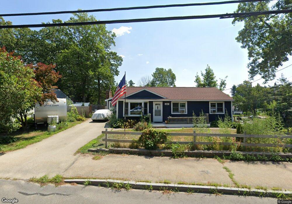
494 Broad St Nashua, NH 03063
Northwest Nashua NeighborhoodEstimated Value: $488,532 - $587,000
3
Beds
2
Baths
1,370
Sq Ft
$384/Sq Ft
Est. Value
About This Home
This home is located at 494 Broad St, Nashua, NH 03063 and is currently estimated at $526,133, approximately $384 per square foot. 494 Broad St is a home located in Hillsborough County with nearby schools including Broad Street Elementary School, Elm Street Middle School, and Nashua High School North.
Ownership History
Date
Name
Owned For
Owner Type
Purchase Details
Closed on
Oct 21, 2021
Sold by
Gust Susan E
Bought by
Bishop Industries Llc
Current Estimated Value
Purchase Details
Closed on
Oct 18, 1996
Sold by
Gath Daniel W and Gath Theresa M
Bought by
Grant Susan E
Home Financials for this Owner
Home Financials are based on the most recent Mortgage that was taken out on this home.
Original Mortgage
$85,850
Interest Rate
8.26%
Create a Home Valuation Report for This Property
The Home Valuation Report is an in-depth analysis detailing your home's value as well as a comparison with similar homes in the area
Home Values in the Area
Average Home Value in this Area
Purchase History
| Date | Buyer | Sale Price | Title Company |
|---|---|---|---|
| Bishop Industries Llc | $274,000 | None Available | |
| Grant Susan E | $99,800 | -- |
Source: Public Records
Mortgage History
| Date | Status | Borrower | Loan Amount |
|---|---|---|---|
| Previous Owner | Grant Susan E | $201,050 | |
| Previous Owner | Grant Susan E | $219,000 | |
| Previous Owner | Grant Susan E | $85,850 |
Source: Public Records
Tax History Compared to Growth
Tax History
| Year | Tax Paid | Tax Assessment Tax Assessment Total Assessment is a certain percentage of the fair market value that is determined by local assessors to be the total taxable value of land and additions on the property. | Land | Improvement |
|---|---|---|---|---|
| 2024 | $7,767 | $488,500 | $162,700 | $325,800 |
| 2023 | $7,398 | $405,800 | $130,200 | $275,600 |
| 2022 | $7,333 | $405,800 | $130,200 | $275,600 |
| 2021 | $6,253 | $269,300 | $86,800 | $182,500 |
| 2020 | $6,087 | $269,200 | $86,800 | $182,400 |
| 2019 | $5,858 | $269,200 | $86,800 | $182,400 |
| 2018 | $5,710 | $269,200 | $86,800 | $182,400 |
| 2017 | $5,437 | $210,800 | $70,900 | $139,900 |
| 2016 | $5,285 | $210,800 | $70,900 | $139,900 |
| 2015 | $5,171 | $210,800 | $70,900 | $139,900 |
| 2014 | $5,070 | $210,800 | $70,900 | $139,900 |
Source: Public Records
Map
Nearby Homes
- 3 Richmond St
- 4 Nelson St
- 6 Cornwall Ln Unit 7
- 5 Meghan Dr Unit U23
- 27 Country Hill Rd Unit U90
- 14 Parrish Hill Dr
- 22 Cathedral Cir
- 424 Broad St
- 11 Inca Dr
- 76 Bartemus Trail Unit U231
- 46 Scenic Dr
- 334 Broad St
- 11 Bartemus Trail Unit 204
- 36 Hampton Dr
- 599 W Hollis St
- 40 Spring Cove Rd Unit U117
- 20 Martha St
- 12 Spring Cove Rd Unit U103
- 8 Althea Ln Unit U26
- 47 Dogwood Dr Unit U202
- 492 Broad St
- 3 Unicorn Way
- 2 Piermont St
- 1 Piermont St
- 3 Piermont St
- 490 Broad St
- 3 Dedham St
- 14 Yorkshire Ln Unit U47
- 3 Randolph St
- 503 Broad St
- 5 Dedham St
- 10 Yorkshire Ln Unit U45
- 16 Yorkshire Ln Unit U48
- 500 Broad St
- 6 Piermont St
- 3 Pelham St
- 505 Broad St
- 2 Pelham St
- 488 Broad St
- 8 Yorkshire Ln Unit U44