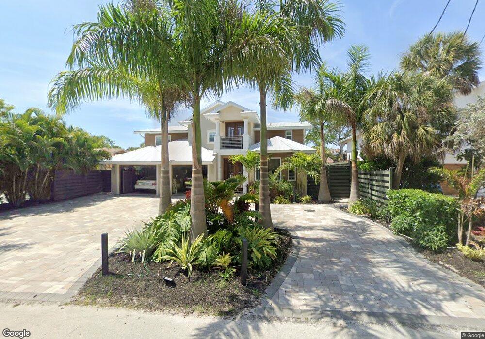
4942 Commonwealth Dr Sarasota, FL 34242
Estimated Value: $1,337,000 - $1,923,000
3
Beds
2
Baths
2,062
Sq Ft
$769/Sq Ft
Est. Value
About This Home
This home is located at 4942 Commonwealth Dr, Sarasota, FL 34242 and is currently estimated at $1,585,132, approximately $768 per square foot. 4942 Commonwealth Dr is a home located in Sarasota County with nearby schools including Phillippi Shores Elementary School, Brookside Middle School, and Sarasota High School.
Ownership History
Date
Name
Owned For
Owner Type
Purchase Details
Closed on
Jan 19, 2016
Sold by
Gutierrez Alex
Bought by
Gutierrez Alex and Taylor Angel Renee
Current Estimated Value
Purchase Details
Closed on
Jul 7, 2014
Sold by
Milligan Michael T
Bought by
Gutierrez Alex
Purchase Details
Closed on
Sep 3, 1997
Sold by
Craddock Gary D and Craddock Wendy S
Bought by
Milligan Michael T
Create a Home Valuation Report for This Property
The Home Valuation Report is an in-depth analysis detailing your home's value as well as a comparison with similar homes in the area
Home Values in the Area
Average Home Value in this Area
Purchase History
| Date | Buyer | Sale Price | Title Company |
|---|---|---|---|
| Gutierrez Alex | -- | Attorney | |
| Gutierrez Alex | $645,000 | Attorney | |
| Milligan Michael T | $250,000 | -- |
Source: Public Records
Mortgage History
| Date | Status | Borrower | Loan Amount |
|---|---|---|---|
| Previous Owner | Milligan Michael T | $120,000 |
Source: Public Records
Tax History Compared to Growth
Tax History
| Year | Tax Paid | Tax Assessment Tax Assessment Total Assessment is a certain percentage of the fair market value that is determined by local assessors to be the total taxable value of land and additions on the property. | Land | Improvement |
|---|---|---|---|---|
| 2024 | $2,760 | $1,005,330 | -- | -- |
| 2023 | $2,760 | $923,427 | $0 | $0 |
| 2022 | $2,633 | $896,531 | $0 | $0 |
| 2021 | $10,784 | $870,418 | $0 | $0 |
| 2020 | $7,158 | $572,266 | $0 | $0 |
| 2019 | $6,939 | $559,400 | $377,800 | $181,600 |
| 2018 | $0 | $596,566 | $0 | $0 |
| 2017 | $7,362 | $584,296 | $0 | $0 |
| 2016 | $7,361 | $606,700 | $402,100 | $204,600 |
| 2015 | $7,501 | $568,300 | $391,800 | $176,500 |
| 2014 | $4,162 | $311,134 | $0 | $0 |
Source: Public Records
Map
Nearby Homes
- 4931 Oxford Dr
- 4929 Oxford Dr
- 4964 Commonwealth Dr
- 4903 Commonwealth Dr
- 717 Treasure Boat Way
- 4894 Oxford Dr
- 4879 Commonwealth Dr
- 711 Birdsong Ln
- 5024 Commonwealth Dr
- 5019 Commonwealth Dr
- 782 Birdsong Ln
- 4859 Commonwealth Dr
- 5141 Saint Albans Ave
- 795 Plymouth St
- 635 Tropical Cir
- 746 Plymouth St
- 5112 Oakmont Place
- 5169 Oxford Dr
- 681 Avenida de Mayo
- 5073 Higel Ave
- 4938 Commonwealth Dr
- 4946 Drive
- 4946 Commonwealth Dr
- 4950 Commonwealth Dr
- 4934 Commonwealth Dr
- 4947 Commonwealth Dr
- 4953 Commonwealth Dr
- 4953 Commonwealth Dr Unit N/S
- 4931 Commonwealth Dr
- 4969 Oxford Dr
- 4963 Oxford Dr
- 4932 Commonwealth Dr
- 5029 Oxford Dr
- 4960 Commonwealth Dr
- 4959 Oxford Dr
- 4923 Commonwealth Dr
- 4926 Commonwealth Dr
- 742 Birdsong Ln
- 726 Birdsong Ln
- 4937 Oxford Dr