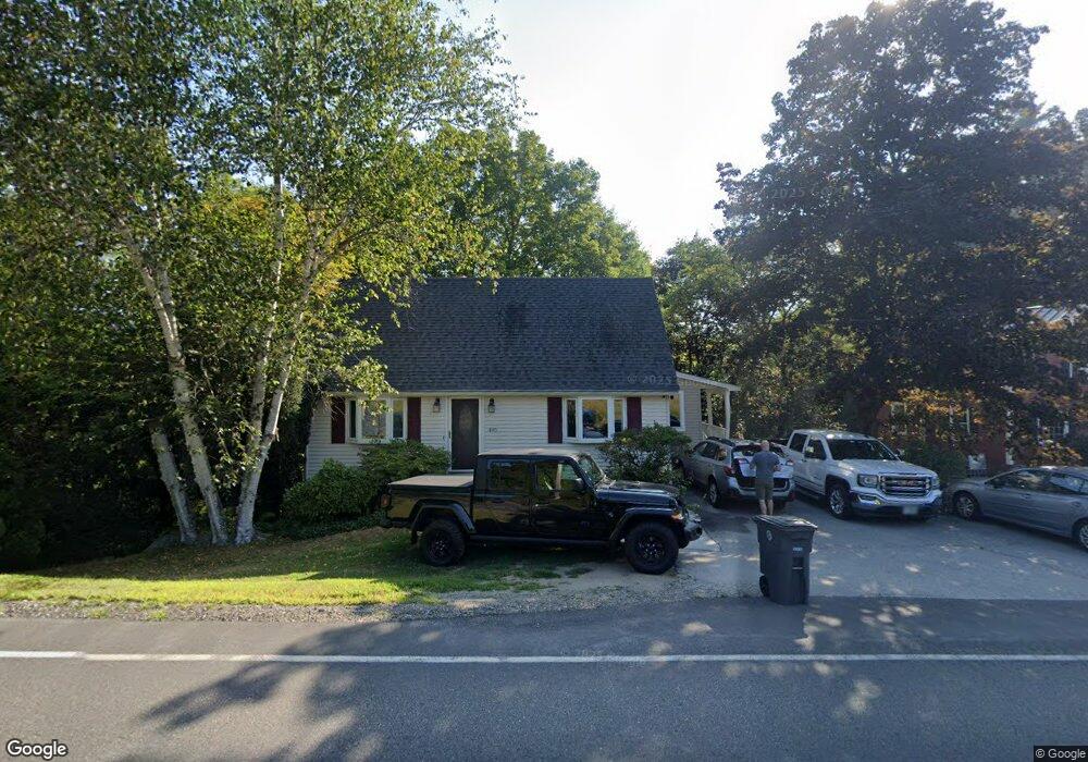
495 West River Rd Hooksett, NH 03106
Estimated Value: $439,065 - $494,000
3
Beds
2
Baths
1,344
Sq Ft
$347/Sq Ft
Est. Value
About This Home
This home is located at 495 West River Rd, Hooksett, NH 03106 and is currently estimated at $466,016, approximately $346 per square foot. 495 West River Rd is a home located in Merrimack County with nearby schools including Fred C. Underhill School, Hooksett Memorial School, and David R. Cawley Middle School.
Ownership History
Date
Name
Owned For
Owner Type
Purchase Details
Closed on
May 11, 2017
Sold by
Nelson Kenneth A and Nelson Michelle L
Bought by
Kenneth & M Nelson Ft
Current Estimated Value
Purchase Details
Closed on
Jun 30, 1997
Sold by
Davis Roger A and Davis Gail A
Bought by
Kenyon Robert F and Kenyon Carrie A
Home Financials for this Owner
Home Financials are based on the most recent Mortgage that was taken out on this home.
Original Mortgage
$96,750
Interest Rate
7.81%
Create a Home Valuation Report for This Property
The Home Valuation Report is an in-depth analysis detailing your home's value as well as a comparison with similar homes in the area
Home Values in the Area
Average Home Value in this Area
Purchase History
| Date | Buyer | Sale Price | Title Company |
|---|---|---|---|
| Kenneth & M Nelson Ft | -- | -- | |
| Kenyon Robert F | $97,600 | -- |
Source: Public Records
Mortgage History
| Date | Status | Borrower | Loan Amount |
|---|---|---|---|
| Previous Owner | Kenyon Robert F | $151,802 | |
| Previous Owner | Kenyon Robert F | $163,500 | |
| Previous Owner | Kenyon Robert F | $96,750 |
Source: Public Records
Tax History
| Year | Tax Paid | Tax Assessment Tax Assessment Total Assessment is a certain percentage of the fair market value that is determined by local assessors to be the total taxable value of land and additions on the property. | Land | Improvement |
|---|---|---|---|---|
| 2024 | $5,958 | $351,300 | $118,900 | $232,400 |
| 2023 | $5,614 | $351,300 | $118,900 | $232,400 |
| 2022 | $5,063 | $210,500 | $77,700 | $132,800 |
| 2021 | $4,677 | $210,500 | $77,700 | $132,800 |
| 2020 | $4,709 | $209,200 | $77,700 | $131,500 |
| 2019 | $4,508 | $209,200 | $77,700 | $131,500 |
| 2018 | $6,748 | $209,200 | $77,700 | $131,500 |
| 2017 | $4,487 | $167,800 | $65,000 | $102,800 |
| 2016 | $4,428 | $167,800 | $65,000 | $102,800 |
| 2015 | $4,148 | $167,800 | $65,000 | $102,800 |
| 2014 | $4,166 | $167,800 | $65,000 | $102,800 |
| 2013 | $3,940 | $167,800 | $65,000 | $102,800 |
Source: Public Records
Map
Nearby Homes
- 117 Merrimack St
- 2 Brandywine Dr
- 131 Merrimack St
- 8 Short Ave
- 1821 Hooksett Rd
- 9 Pleasant View Dr
- 1601 Hooksett Rd
- 7 Oak St
- 7 Morgan Dr
- 15 Whitten St
- 422 Dawn Dr Unit 23
- 427 Dawn Dr Unit 15
- 430 Dawn Dr Unit 20
- 0 Granite St Unit 48
- 1465 Hooksett Rd Unit 287
- 1465 Hooksett Rd Unit 418
- 1465 Hooksett Rd Unit 183
- 1465 Hooksett Rd Unit 390
- 19 Sullivan Dr
- 135 Main St
- 493 West River Rd
- 496 W River Rd
- 498 West River Rd
- 39 Edgewater Dr
- 496 West River Rd
- 491 West River Rd
- 494 West River Rd
- 500 West River Rd
- 494 W River Rd
- 8 Pine St
- 523 W River Rd
- 489 W River Rd
- 489 West River Rd
- 12 Pine St
- 492 West River Rd
- 16 Pine St
- 20 Pine St
- 487 West River Rd
- 1 Pine St
- 11 Pine St
Your Personal Tour Guide
Ask me questions while you tour the home.