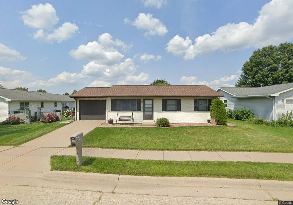
4951 Northrange Ct Dubuque, IA 52002
Estimated Value: $229,461 - $253,000
3
Beds
2
Baths
936
Sq Ft
$262/Sq Ft
Est. Value
About This Home
This home is located at 4951 Northrange Ct, Dubuque, IA 52002 and is currently estimated at $245,365, approximately $262 per square foot. 4951 Northrange Ct is a home located in Dubuque County with nearby schools including Carver Elementary School, Eleanor Roosevelt Middle School, and Hempstead High School.
Ownership History
Date
Name
Owned For
Owner Type
Purchase Details
Closed on
Aug 20, 2009
Sold by
Halkowski Darin J and Halkowski Jessica M
Bought by
Burrows Michael R and Burrows Ramona A
Current Estimated Value
Purchase Details
Closed on
Jul 29, 2005
Sold by
Klaeska Carl F and Klaeska Sara M
Bought by
Halkowski Darin J and Reilly Jessica M
Home Financials for this Owner
Home Financials are based on the most recent Mortgage that was taken out on this home.
Original Mortgage
$106,166
Interest Rate
5.66%
Mortgage Type
New Conventional
Create a Home Valuation Report for This Property
The Home Valuation Report is an in-depth analysis detailing your home's value as well as a comparison with similar homes in the area
Purchase History
| Date | Buyer | Sale Price | Title Company |
|---|---|---|---|
| Burrows Michael R | $142,500 | None Available | |
| Halkowski Darin J | $109,500 | None Available |
Source: Public Records
Mortgage History
| Date | Status | Borrower | Loan Amount |
|---|---|---|---|
| Previous Owner | Halkowski Darin J | $106,166 |
Source: Public Records
Tax History
| Year | Tax Paid | Tax Assessment Tax Assessment Total Assessment is a certain percentage of the fair market value that is determined by local assessors to be the total taxable value of land and additions on the property. | Land | Improvement |
|---|---|---|---|---|
| 2025 | $2,496 | $209,400 | $35,000 | $174,400 |
| 2024 | $2,496 | $197,500 | $33,400 | $164,100 |
| 2023 | $2,514 | $197,500 | $33,400 | $164,100 |
| 2022 | $2,556 | $163,530 | $31,800 | $131,730 |
| 2021 | $2,556 | $163,530 | $31,800 | $131,730 |
| 2020 | $2,504 | $149,620 | $31,800 | $117,820 |
| 2019 | $2,492 | $149,620 | $31,800 | $117,820 |
| 2018 | $2,450 | $142,560 | $28,620 | $113,940 |
| 2017 | $2,346 | $142,560 | $28,620 | $113,940 |
| 2016 | $2,294 | $129,960 | $28,620 | $101,340 |
| 2015 | $2,294 | $129,960 | $28,620 | $101,340 |
| 2014 | $2,232 | $129,960 | $28,620 | $101,340 |
Source: Public Records
Map
Nearby Homes
- 3831 Cora Dr
- 0 Associates Dr
- 2285 Julia Dr
- 2287 Julia Dr
- 2071 Ellen St
- 2301 Helle Dr
- 2266 Antler Ridge Dr
- 1804 Norland Dr
- 1718 Richie Dr
- 4400 Dodge St
- 2191 Graham Cir
- 2319 Harvest View Dr
- 4223 Chavenelle Rd
- 2201 Del Monaco Dr
- 5680 Sun Valley Dr
- 0 Chavenelle Unit at Seippel Road
- 0 Chavenelle Unit 4050 Westmark Drive
- 2281 Pasadena Dr
- 2315 Pasadena Dr
- 3349 Kaufmann Ave
- 4947 Northrange Ct
- 1826 Dallas Ct
- 1838 Dallas Ct
- 4943 Northrange Ct
- 1852 Dallas Ct
- 4954 Northrange Ct
- 4958 Northrange Ct
- 1831 Dallas Ct
- 4923 Northrange Ct
- 4962 Northrange Ct
- 1815 Embassy West Dr
- 1874 Dallas Ct
- 1801 Embassy West Dr
- 1847 Dallas Ct
- 4967 Northrange Ct
- 4966 Northrange Ct
- 4930 Northrange Ct
- 1801 Embassy Dr W
- 1825 Embassy West Dr
- 0 Wolff Rd
Your Personal Tour Guide
Ask me questions while you tour the home.