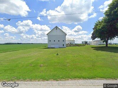
4971 Opperman Rd Bellevue, OH 44811
Estimated Value: $182,000 - $241,000
4
Beds
2
Baths
2,040
Sq Ft
$99/Sq Ft
Est. Value
About This Home
This home is located at 4971 Opperman Rd, Bellevue, OH 44811 and is currently estimated at $201,385, approximately $98 per square foot. 4971 Opperman Rd is a home located in Huron County with nearby schools including Bellevue Elementary School, Bellevue Middle School, and Bellevue High School.
Ownership History
Date
Name
Owned For
Owner Type
Purchase Details
Closed on
Dec 19, 2022
Sold by
Sackett Sylvia A and Kaltenbach Rebecca L
Bought by
Sackett Paul S and Crispin Sara A
Current Estimated Value
Purchase Details
Closed on
Dec 11, 2019
Sold by
Sherman Kenton D
Bought by
Sackett Sylvia A and Kaltenbach Rebecca L
Purchase Details
Closed on
Apr 5, 2018
Sold by
Sherman Kenton D and Ila Mae Sherman Trust
Bought by
Sherman Kenton D
Purchase Details
Closed on
Jan 9, 2018
Sold by
Sherman Kenton D
Bought by
Sherman Kenton D and Kenton D Sherman Trust
Purchase Details
Closed on
Apr 27, 2007
Bought by
Sherman Kenton D Trustee
Purchase Details
Closed on
Aug 14, 2000
Bought by
Sherman Kenton D Trustee
Purchase Details
Closed on
Jun 25, 1996
Bought by
Sherman Ila
Purchase Details
Closed on
Jun 5, 1996
Bought by
Sherman Ila
Purchase Details
Closed on
Apr 25, 1994
Bought by
Sherman Ila Trustee
Create a Home Valuation Report for This Property
The Home Valuation Report is an in-depth analysis detailing your home's value as well as a comparison with similar homes in the area
Home Values in the Area
Average Home Value in this Area
Purchase History
| Date | Buyer | Sale Price | Title Company |
|---|---|---|---|
| Sackett Paul S | -- | -- | |
| Sackett Sylvia A | -- | None Available | |
| Sherman Kenton D | -- | None Available | |
| Sherman Kenton D | -- | None Available | |
| Sherman Kenton D | -- | None Available | |
| Sherman Kenton D Trustee | -- | -- | |
| Sherman Kenton D Trustee | -- | -- | |
| Sherman Ila | -- | -- | |
| Sherman Ila | -- | -- | |
| Sherman Ila Trustee | -- | -- |
Source: Public Records
Tax History Compared to Growth
Tax History
| Year | Tax Paid | Tax Assessment Tax Assessment Total Assessment is a certain percentage of the fair market value that is determined by local assessors to be the total taxable value of land and additions on the property. | Land | Improvement |
|---|---|---|---|---|
| 2024 | $2,016 | $47,100 | $12,270 | $34,830 |
| 2023 | $2,016 | $39,290 | $9,140 | $30,150 |
| 2022 | $1,964 | $42,810 | $9,140 | $33,670 |
| 2021 | $1,979 | $42,810 | $9,140 | $33,670 |
| 2020 | $2,079 | $42,810 | $9,010 | $33,800 |
| 2019 | $2,046 | $42,810 | $9,010 | $33,800 |
| 2018 | $2,021 | $42,810 | $9,010 | $33,800 |
| 2017 | $1,775 | $39,370 | $8,920 | $30,450 |
| 2016 | $1,722 | $39,370 | $8,920 | $30,450 |
| 2015 | $1,761 | $39,380 | $8,920 | $30,460 |
| 2014 | $1,642 | $35,290 | $8,930 | $26,360 |
| 2013 | $1,640 | $35,290 | $8,930 | $26,360 |
Source: Public Records
Map
Nearby Homes
- 3050 E Main St
- 3000 E Main St
- 407 Monroe St
- 10 Eagle View Dr
- 121 North St
- 5041 State Route 99 N
- 807 E Main St
- 60 Manchester St
- 924 E Main St
- 120 Mckim St
- 244 Pleasant St
- 419 N Sandusky St
- 115 Union St
- 126 Roger Ave
- 219 Greenwood Heights
- 129 Howard St
- 624 Shumaker Dr
- 118 Maplewood
- 0 Hartland Dr
- 120 Redwood Dr
- 4971 Opperman Rd
- 3411 Sandhill Rd
- 3427 Sandhill Rd
- 3337 Sandhill Rd
- 4077 Sand Hill Rd
- 3303 Sandhill Rd
- 5220 Opperman Rd
- 5236 Opperman Rd
- 3250 Sandhill Rd
- 5313 Opperman Rd
- 3645 Sandhill Rd
- 3149 Sandhill Rd
- 5001 State Route 547
- 4727 State Route 547
- 4635 State Route 547
- 4608 State Route 547
- 4584 State Route 547
- 4623 State Route 547
- 4623 State Route 547
- 3695 Sandhill Rd