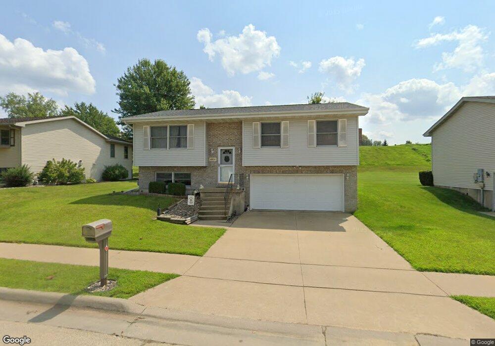
4974 Northrange Ct Dubuque, IA 52002
Estimated Value: $247,981 - $272,000
3
Beds
2
Baths
1,026
Sq Ft
$253/Sq Ft
Est. Value
About This Home
This home is located at 4974 Northrange Ct, Dubuque, IA 52002 and is currently estimated at $259,245, approximately $252 per square foot. 4974 Northrange Ct is a home located in Dubuque County with nearby schools including Carver Elementary School, Eleanor Roosevelt Middle School, and Hempstead High School.
Ownership History
Date
Name
Owned For
Owner Type
Purchase Details
Closed on
Jul 17, 2010
Sold by
Bergeron Thomas J and Bergeron Thomas
Bought by
Bergeron Thomas J and Bergeron Amy J
Current Estimated Value
Home Financials for this Owner
Home Financials are based on the most recent Mortgage that was taken out on this home.
Original Mortgage
$158,049
Interest Rate
4.81%
Mortgage Type
VA
Create a Home Valuation Report for This Property
The Home Valuation Report is an in-depth analysis detailing your home's value as well as a comparison with similar homes in the area
Home Values in the Area
Average Home Value in this Area
Purchase History
| Date | Buyer | Sale Price | Title Company |
|---|---|---|---|
| Bergeron Thomas J | -- | None Available |
Source: Public Records
Mortgage History
| Date | Status | Borrower | Loan Amount |
|---|---|---|---|
| Closed | Bergeron Thomas J | $158,049 |
Source: Public Records
Tax History Compared to Growth
Tax History
| Year | Tax Paid | Tax Assessment Tax Assessment Total Assessment is a certain percentage of the fair market value that is determined by local assessors to be the total taxable value of land and additions on the property. | Land | Improvement |
|---|---|---|---|---|
| 2025 | $2,862 | $234,200 | $44,700 | $189,500 |
| 2024 | $2,862 | $217,700 | $42,600 | $175,100 |
| 2023 | $2,772 | $217,700 | $42,600 | $175,100 |
| 2022 | $2,758 | $179,130 | $40,600 | $138,530 |
| 2021 | $2,758 | $179,130 | $40,600 | $138,530 |
| 2020 | $2,716 | $164,920 | $40,600 | $124,320 |
| 2019 | $2,706 | $164,920 | $40,600 | $124,320 |
| 2018 | $2,658 | $157,270 | $36,540 | $120,730 |
| 2017 | $2,524 | $157,270 | $36,540 | $120,730 |
| 2016 | $2,524 | $142,470 | $36,540 | $105,930 |
| 2015 | $2,468 | $142,470 | $36,540 | $105,930 |
| 2014 | $2,400 | $142,470 | $36,540 | $105,930 |
Source: Public Records
Map
Nearby Homes
- 1650 Alicia St
- 2207 Eldie Dr
- 0 Associates Dr
- Lot 3 Shagbark Plat 3 Ln Unit 4461 Barnwood Lane
- 2249 Antler Ridge Dr
- 5133 Asbury Rd
- 1743 Lea Ln
- 4400 Dodge St
- 4223 Chavenelle Rd
- 3424 Glencove Ln
- 3427 Crestwood Dr
- 2685 Springreen Dr
- 2332 Briarwood Dr
- 2418 Hacienda Dr
- 0 Chavenelle Unit at Seippel Road
- 0 Chavenelle Unit 4050 Westmark Drive
- 1860 Carter Rd
- 2281 Pasadena Dr
- 73.43 acres Old Highway Rd
- 6100 Lynbrook Dr
- 4978 Northrange Ct
- 4970 Northrange Ct
- 4982 Northrange Ct
- 4966 Northrange Ct
- 4971 Northrange Ct
- 4986 Northrange Ct
- 1822 North Ct
- 4135 Pennsylvania Ave
- 4967 Northrange Ct
- 4962 Northrange Ct
- 1831 Dallas Ct
- 4990 Northrange Ct
- 1834 North Ct
- 4958 Northrange Ct
- 1825 North Ct
- 1847 Dallas Ct
- 1826 Dallas Ct
- 1856 North Ct
- 4954 Northrange Ct
- 0 Wolff Rd