Estimated Value: $262,703 - $292,000
3
Beds
2
Baths
1,342
Sq Ft
$207/Sq Ft
Est. Value
About This Home
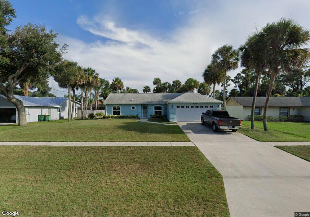
This home is located at 4975 Falcon Blvd, Cocoa, FL 32927 and is currently estimated at $277,352, approximately $206 per square foot. 4975 Falcon Blvd is a home located in Brevard County with nearby schools including Atlantis Elementary School, Space Coast Junior/Senior High School, and Sculptor Charter School.
Ownership History
Date
Name
Owned For
Owner Type
Purchase Details
Closed on
May 29, 1996
Sold by
Demartino Carol L
Bought by
Perdue Chris A and Perdue Lisa A
Current Estimated Value
Purchase Details
Closed on
Mar 28, 1994
Sold by
Maronda Homes Inc Fl
Bought by
Demartino Carol L
Home Financials for this Owner
Home Financials are based on the most recent Mortgage that was taken out on this home.
Original Mortgage
$74,469
Interest Rate
7.2%
Mortgage Type
FHA
Purchase Details
Closed on
Dec 17, 1993
Sold by
Sheu Tsailing Elaine
Bought by
Maronda Homes Inc Fl
Create a Home Valuation Report for This Property
The Home Valuation Report is an in-depth analysis detailing your home's value as well as a comparison with similar homes in the area
Home Values in the Area
Average Home Value in this Area
Purchase History
| Date | Buyer | Sale Price | Title Company |
|---|---|---|---|
| Perdue Chris A | $80,000 | -- | |
| Demartino Carol L | $74,100 | -- | |
| Maronda Homes Inc Fl | -- | -- |
Source: Public Records
Mortgage History
| Date | Status | Borrower | Loan Amount |
|---|---|---|---|
| Previous Owner | Demartino Carol L | $74,469 |
Source: Public Records
Tax History
| Year | Tax Paid | Tax Assessment Tax Assessment Total Assessment is a certain percentage of the fair market value that is determined by local assessors to be the total taxable value of land and additions on the property. | Land | Improvement |
|---|---|---|---|---|
| 2025 | $1,149 | $86,200 | -- | -- |
| 2024 | $1,115 | $83,780 | -- | -- |
| 2023 | $1,115 | $81,340 | -- | -- |
| 2022 | $1,034 | $78,980 | $0 | $0 |
| 2021 | $1,023 | $76,680 | $0 | $0 |
| 2020 | $970 | $75,630 | $0 | $0 |
| 2019 | $913 | $73,930 | $0 | $0 |
| 2018 | $915 | $72,560 | $0 | $0 |
| 2017 | $917 | $71,070 | $0 | $0 |
| 2016 | $926 | $69,610 | $18,000 | $51,610 |
Source: Public Records
Map
Nearby Homes
- 7155 Export Ave
- 7245 Grissom Pkwy
- 5200 Frisco St
- 5080 Mayflower St
- 7275 Durban Ave
- 5150 Melody St
- 5165 Patricia St
- 5155 Mayflower St
- 4824 Curtis Blvd
- 6990 Camden Ave
- 0 Cinnamon Fern Blvd
- 7310 Joshua Place
- 4760 Ivan St
- 4625 Curtis Blvd
- 7456 Camio Ave
- 6990 Bryant Rd
- 6820 Caliph Ave
- 5095 Hogan Place
- 7545 Fringe Place
- 4790 Greenhill St
- 4965 Falcon Blvd
- 4983 Falcon Blvd
- 4980 Patricia St
- 4972 Patricia St
- 4988 Patricia St
- 4959 Falcon Blvd
- 4991 Falcon Blvd
- 4964 Patricia St
- 4951 Falcon Blvd
- 7100 Hartman St
- 7101 Hartman St
- 4956 Patricia St
- 4990 Falcon Blvd
- 4983 Patricia St
- 4985 Patricia St
- 4971 Patricia St
- 4945 Falcon Blvd
- 7109 Hartman St
- 4950 Falcon Blvd
- 7045 Grissom Pkwy
Your Personal Tour Guide
Ask me questions while you tour the home.