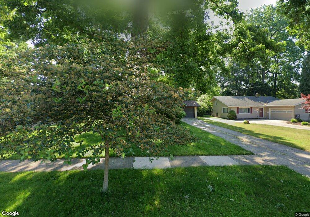
4989 Devon Dr North Olmsted, OH 44070
Estimated Value: $291,000 - $324,000
4
Beds
2
Baths
2,232
Sq Ft
$139/Sq Ft
Est. Value
About This Home
This home is located at 4989 Devon Dr, North Olmsted, OH 44070 and is currently estimated at $309,325, approximately $138 per square foot. 4989 Devon Dr is a home located in Cuyahoga County with nearby schools including Chestnut Intermediate Elementary School, Pine Intermediate School, and North Olmsted Middle School.
Ownership History
Date
Name
Owned For
Owner Type
Purchase Details
Closed on
Jul 14, 2004
Sold by
Cordell Stanley A and Cordell Marian M
Bought by
Montgomery Lisa A
Current Estimated Value
Home Financials for this Owner
Home Financials are based on the most recent Mortgage that was taken out on this home.
Original Mortgage
$162,856
Outstanding Balance
$78,792
Interest Rate
6.4%
Mortgage Type
FHA
Estimated Equity
$230,533
Purchase Details
Closed on
May 5, 1999
Sold by
Silski Catherine L
Bought by
Cordell Stanley A and Cordell Marian M
Home Financials for this Owner
Home Financials are based on the most recent Mortgage that was taken out on this home.
Original Mortgage
$121,200
Interest Rate
7.04%
Purchase Details
Closed on
Dec 3, 1984
Sold by
Silski Carl L and Silski Catherine L
Bought by
Silski Catherine L
Purchase Details
Closed on
Jan 1, 1975
Bought by
Silski Carl L and Silski Catherine L
Create a Home Valuation Report for This Property
The Home Valuation Report is an in-depth analysis detailing your home's value as well as a comparison with similar homes in the area
Home Values in the Area
Average Home Value in this Area
Purchase History
| Date | Buyer | Sale Price | Title Company |
|---|---|---|---|
| Montgomery Lisa A | $165,000 | Real Living Title Agency L | |
| Cordell Stanley A | $151,500 | Real Estate Title | |
| Silski Catherine L | -- | -- | |
| Silski Carl L | -- | -- |
Source: Public Records
Mortgage History
| Date | Status | Borrower | Loan Amount |
|---|---|---|---|
| Open | Montgomery Lisa A | $162,856 | |
| Previous Owner | Cordell Stanley A | $121,200 |
Source: Public Records
Tax History
| Year | Tax Paid | Tax Assessment Tax Assessment Total Assessment is a certain percentage of the fair market value that is determined by local assessors to be the total taxable value of land and additions on the property. | Land | Improvement |
|---|---|---|---|---|
| 2025 | $6,169 | $91,000 | $17,885 | $73,115 |
| 2024 | $6,237 | $91,000 | $17,885 | $73,115 |
| 2023 | $5,712 | $69,940 | $14,040 | $55,900 |
| 2022 | $5,682 | $69,930 | $14,040 | $55,900 |
| 2021 | $5,142 | $69,930 | $14,040 | $55,900 |
| 2020 | $4,963 | $59,780 | $12,010 | $47,780 |
| 2019 | $4,830 | $170,800 | $34,300 | $136,500 |
| 2018 | $4,898 | $59,780 | $12,010 | $47,780 |
| 2017 | $4,716 | $52,990 | $9,870 | $43,120 |
| 2016 | $4,675 | $52,990 | $9,870 | $43,120 |
| 2015 | $4,565 | $52,990 | $9,870 | $43,120 |
| 2014 | $4,565 | $51,450 | $9,590 | $41,860 |
Source: Public Records
Map
Nearby Homes
- 5229 Evergreen Dr
- 4623 Martin Dr
- 4650 Crocker Woods Ln
- 5536 Mackenzie Rd
- 27693 Butternut Ridge
- 4553 Porter Rd
- 5729 Forest Ridge Dr
- 5610 Dorothy Dr
- 30051 Center Ridge Rd Unit A
- 5678 Decker Rd
- 29852 Lenox Dr
- 27015 Kennedy Ridge Extension
- S/L Carlton Ave
- 5933 Decker Rd
- 27974 Sanders Ln
- 25555 Country Club Blvd
- 25600 Country Club Blvd Unit 12
- 25600 Country Club Blvd Unit 4
- 28469 Windsor Dr
- 30603 Carlton Ave
- 5003 Devon Dr
- 4975 Devon Dr
- 5017 Devon Dr
- 4961 Devon Dr
- 4988 Berkshire Dr
- 5000 Berkshire Dr
- 4974 Berkshire Dr
- 4947 Devon Dr
- 5031 Devon Dr
- 4960 Berkshire Dr
- 5016 Berkshire Dr
- 4990 Devon Dr
- 4976 Devon Dr
- 5002 Devon Dr
- 4962 Devon Dr
- 5018 Devon Dr
- 4946 Berkshire Dr
- 5030 Berkshire Dr
- 5045 Devon Dr
- 4933 Devon Dr
Your Personal Tour Guide
Ask me questions while you tour the home.