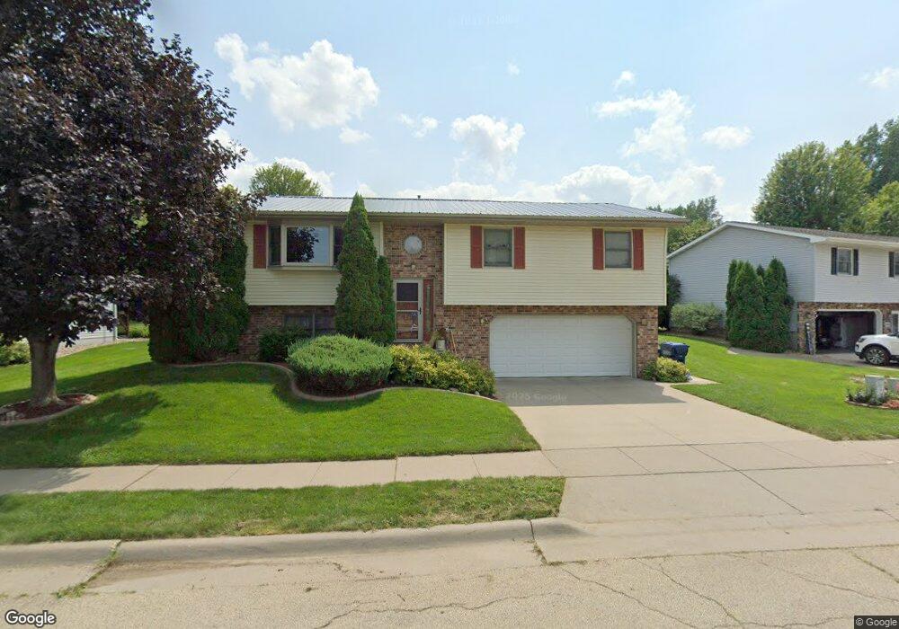
4990 Northrange Ct Dubuque, IA 52002
Estimated Value: $267,030 - $293,000
3
Beds
2
Baths
1,220
Sq Ft
$233/Sq Ft
Est. Value
About This Home
This home is located at 4990 Northrange Ct, Dubuque, IA 52002 and is currently estimated at $283,758, approximately $232 per square foot. 4990 Northrange Ct is a home located in Dubuque County with nearby schools including Carver Elementary School, Eleanor Roosevelt Middle School, and Hempstead High School.
Ownership History
Date
Name
Owned For
Owner Type
Purchase Details
Closed on
May 11, 2005
Sold by
Rupp Richard D and Rupp Patricia M
Bought by
Marquardt Troy L and Marquardt Michelle M
Current Estimated Value
Home Financials for this Owner
Home Financials are based on the most recent Mortgage that was taken out on this home.
Original Mortgage
$118,400
Outstanding Balance
$62,644
Interest Rate
6.07%
Mortgage Type
New Conventional
Estimated Equity
$221,114
Create a Home Valuation Report for This Property
The Home Valuation Report is an in-depth analysis detailing your home's value as well as a comparison with similar homes in the area
Home Values in the Area
Average Home Value in this Area
Purchase History
| Date | Buyer | Sale Price | Title Company |
|---|---|---|---|
| Marquardt Troy L | $148,000 | None Available |
Source: Public Records
Mortgage History
| Date | Status | Borrower | Loan Amount |
|---|---|---|---|
| Open | Marquardt Troy L | $118,400 |
Source: Public Records
Tax History Compared to Growth
Tax History
| Year | Tax Paid | Tax Assessment Tax Assessment Total Assessment is a certain percentage of the fair market value that is determined by local assessors to be the total taxable value of land and additions on the property. | Land | Improvement |
|---|---|---|---|---|
| 2025 | $3,150 | $246,200 | $41,500 | $204,700 |
| 2024 | $3,150 | $229,300 | $39,600 | $189,700 |
| 2023 | $3,054 | $229,300 | $39,600 | $189,700 |
| 2022 | $2,974 | $188,830 | $37,700 | $151,130 |
| 2021 | $2,974 | $188,830 | $37,700 | $151,130 |
| 2020 | $2,926 | $173,340 | $37,700 | $135,640 |
| 2019 | $2,922 | $173,340 | $37,700 | $135,640 |
| 2018 | $2,874 | $165,670 | $33,930 | $131,740 |
| 2017 | $2,852 | $165,670 | $33,930 | $131,740 |
| 2016 | $2,790 | $156,230 | $33,930 | $122,300 |
| 2015 | $2,790 | $156,230 | $33,930 | $122,300 |
| 2014 | $2,714 | $156,230 | $33,930 | $122,300 |
Source: Public Records
Map
Nearby Homes
- 2207 Eldie Dr
- 1555 Donovan Dr
- 0 Associates Dr
- 4957 Twilight Dr
- Lot 6 Mill Ridge Rd
- Lot 3 Shagbark Plat 3 Ln Unit 4461 Barnwood Lane
- Lot 191 Forest Hills Estates Dr Unit 6024 Stockwood Dr
- 2023 Clifford St
- 2249 Antler Ridge Dr
- 5133 Asbury Rd
- 1754 Vizaleea Dr
- 3660 Hillcrest Rd
- 4223 Chavenelle Rd
- Lot Hillcrest Rd
- 3631 Keymeer Dr
- 2145 Saint John Dr
- 3519 Hillcrest Rd
- 2090 Key Largo Dr
- 3575 Lisa Ct
- 3455 Daniels St
- 4986 Northrange Ct
- 4994 Northrange Ct
- 4982 Northrange Ct
- 4998 Northrange Ct
- 1825 North Ct
- 4978 Northrange Ct
- 4991 Northrange Ct
- 4999 Northrange Ct
- 4974 Northrange Ct
- 1822 North Ct
- 1837 North Ct
- 4995 Northrange Ct
- 4971 Northrange Ct
- 4970 Northrange Ct
- 1857 North Ct
- 1834 North Ct
- 4967 Northrange Ct
- 1863 North Ct
- 4966 Northrange Ct
- 1856 North Ct