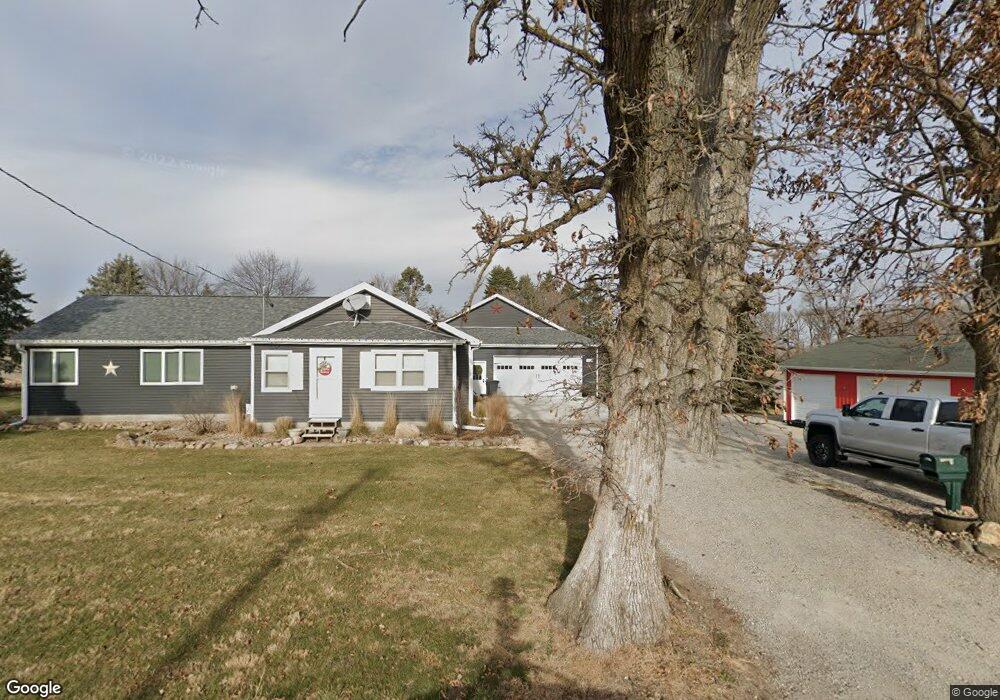
4994 N 19th Ave W Newton, IA 50208
Estimated Value: $237,000 - $439,000
2
Beds
1
Bath
1,032
Sq Ft
$298/Sq Ft
Est. Value
About This Home
This home is located at 4994 N 19th Ave W, Newton, IA 50208 and is currently estimated at $307,170, approximately $297 per square foot. 4994 N 19th Ave W is a home located in Jasper County with nearby schools including Thomas Jefferson Elementary School, Woodrow Wilson Elementary School, and Berg Middle School.
Ownership History
Date
Name
Owned For
Owner Type
Purchase Details
Closed on
May 18, 2018
Sold by
Bell Betty L
Bought by
Braderhorst Benjamin and Braderhorst Michelle
Current Estimated Value
Home Financials for this Owner
Home Financials are based on the most recent Mortgage that was taken out on this home.
Original Mortgage
$192,000
Outstanding Balance
$165,318
Interest Rate
4.4%
Mortgage Type
New Conventional
Estimated Equity
$141,852
Create a Home Valuation Report for This Property
The Home Valuation Report is an in-depth analysis detailing your home's value as well as a comparison with similar homes in the area
Home Values in the Area
Average Home Value in this Area
Purchase History
| Date | Buyer | Sale Price | Title Company |
|---|---|---|---|
| Braderhorst Benjamin | $105,000 | -- |
Source: Public Records
Mortgage History
| Date | Status | Borrower | Loan Amount |
|---|---|---|---|
| Open | Braderhorst Benjamin | $192,000 |
Source: Public Records
Tax History Compared to Growth
Tax History
| Year | Tax Paid | Tax Assessment Tax Assessment Total Assessment is a certain percentage of the fair market value that is determined by local assessors to be the total taxable value of land and additions on the property. | Land | Improvement |
|---|---|---|---|---|
| 2025 | $2,660 | $258,590 | $71,700 | $186,890 |
| 2024 | $2,660 | $204,340 | $47,120 | $157,220 |
| 2023 | $2,578 | $204,340 | $47,120 | $157,220 |
| 2022 | $2,374 | $177,420 | $47,120 | $130,300 |
| 2021 | $2,130 | $160,400 | $47,120 | $113,280 |
| 2020 | $2,130 | $136,590 | $31,800 | $104,790 |
| 2019 | $1,798 | $107,710 | $0 | $0 |
| 2018 | $1,798 | $107,710 | $0 | $0 |
| 2017 | $1,800 | $107,710 | $0 | $0 |
| 2016 | $1,800 | $105,540 | $0 | $0 |
| 2015 | $1,720 | $100,830 | $0 | $0 |
| 2014 | $1,612 | $100,830 | $0 | $0 |
Source: Public Records
Map
Nearby Homes
- 3729 W 56th St N
- 1650 W 28th St N
- 2214 Highway F48 W
- 5323 Highway F36 W
- 299 Hickory St
- 4848 W 48th St N
- 124 Emerson Hough Dr
- 6911-10 Highway F 48 W
- 1149 W 28th St S
- 860 W 28th St S
- TBD W 28th St S
- 549 W 10th St N
- 913 W 18th St S
- 1221 Monroe Dr
- 210 W 13th St S
- 1005 W 8th St N
- 304 W 11th St N
- 1431 Cardinal Ridge Dr
- 237 W 12th St S
- 1100 1st Ave W
- 5281 N 19th Ave W
- 5217 N 23rd Ave W
- 5312 N 23rd Ave W
- 5390 N 23rd Ave W
- 5507 N 19th Ave W
- 4167 N 19th Ave W
- 2035 W 40th St N
- 4236 N 23rd Ave W
- 4393 N 19th Ave W
- 4041 N 19th Ave W
- 0 Meadow Lark Cir Unit 5468657
- 0 Meadow Lark Cir Unit 5468656
- 0 Meadow Lark Cir Unit 5468655
- 0 Meadow Lark Cir Unit 5468654
- 3881 N 19th Ave W
- 2298 W 40th St N
- 3645 Highway F36 W
- 3623 N 19th Ave W
- 3568 N 19th Ave W
- 525 W 52nd St N