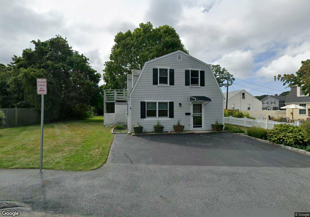
5 Bertoni Rd Gloucester, MA 01930
Estimated Value: $501,000 - $541,000
1
Bed
2
Baths
959
Sq Ft
$544/Sq Ft
Est. Value
About This Home
This home is located at 5 Bertoni Rd, Gloucester, MA 01930 and is currently estimated at $521,657, approximately $543 per square foot. 5 Bertoni Rd is a home located in Essex County with nearby schools including Plum Cove School, Ralph B O'maley Middle School, and Gloucester High School.
Ownership History
Date
Name
Owned For
Owner Type
Purchase Details
Closed on
Feb 28, 2017
Sold by
Omaley Omaley C and Omaley Joyce E
Bought by
Griffin Kathleen O and Brown Richard R
Current Estimated Value
Home Financials for this Owner
Home Financials are based on the most recent Mortgage that was taken out on this home.
Original Mortgage
$150,000
Outstanding Balance
$124,215
Interest Rate
4.12%
Mortgage Type
New Conventional
Estimated Equity
$397,442
Purchase Details
Closed on
Jan 27, 2017
Sold by
Omaley Ralph B and Swicker Kelly A
Bought by
Omaley Omaley C and Omaley Joyce E
Home Financials for this Owner
Home Financials are based on the most recent Mortgage that was taken out on this home.
Original Mortgage
$150,000
Outstanding Balance
$124,215
Interest Rate
4.12%
Mortgage Type
New Conventional
Estimated Equity
$397,442
Purchase Details
Closed on
Jul 10, 2007
Sold by
Omaley C Michael and Omaley Joyce E
Bought by
Omaley Ralph B
Create a Home Valuation Report for This Property
The Home Valuation Report is an in-depth analysis detailing your home's value as well as a comparison with similar homes in the area
Purchase History
| Date | Buyer | Sale Price | Title Company |
|---|---|---|---|
| Griffin Kathleen O | $200,000 | -- | |
| Omaley Omaley C | -- | -- | |
| Omaley Ralph B | -- | -- |
Source: Public Records
Mortgage History
| Date | Status | Borrower | Loan Amount |
|---|---|---|---|
| Open | Griffin Kathleen O | $150,000 | |
| Previous Owner | Omaley Ralph B | $87,000 |
Source: Public Records
Tax History
| Year | Tax Paid | Tax Assessment Tax Assessment Total Assessment is a certain percentage of the fair market value that is determined by local assessors to be the total taxable value of land and additions on the property. | Land | Improvement |
|---|---|---|---|---|
| 2025 | $4,133 | $425,200 | $148,000 | $277,200 |
| 2024 | $4,068 | $418,100 | $140,900 | $277,200 |
| 2023 | $3,896 | $367,900 | $125,900 | $242,000 |
| 2022 | $3,769 | $321,300 | $109,400 | $211,900 |
| 2021 | $3,636 | $292,300 | $99,500 | $192,800 |
| 2020 | $3,530 | $286,300 | $99,500 | $186,800 |
| 2019 | $3,308 | $260,700 | $99,500 | $161,200 |
| 2018 | $3,136 | $242,500 | $99,500 | $143,000 |
| 2017 | $3,039 | $230,400 | $94,800 | $135,600 |
| 2016 | $2,947 | $216,500 | $98,900 | $117,600 |
| 2015 | $2,872 | $210,400 | $98,900 | $111,500 |
Source: Public Records
Map
Nearby Homes
- 3 Rockland St
- 6 Monroe Ct
- 8 Mystic Ave
- 13 Mystic Ave
- 98 Maplewood Ave
- 9 Cleveland Place
- 12 Arthur St
- 15 Harvard St
- 120 Washington St
- 31 Echo Ave
- 40 Sargent St
- 33 Maplewood Ave Unit 310
- 20 Beacon St
- 20 Beacon St Unit 2
- 20 Beacon St Unit 1
- 113 Pleasant St
- 50 Warner St
- 19 Trask St Unit 2
- 13 Leslie o Johnson Rd
- 3 Deacon Farm Ln
Your Personal Tour Guide
Ask me questions while you tour the home.