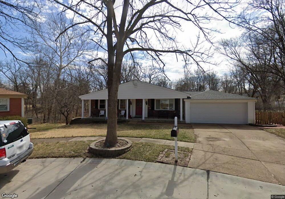
5 Calder Ct Ballwin, MO 63021
Estimated Value: $312,167 - $357,000
3
Beds
4
Baths
1,440
Sq Ft
$238/Sq Ft
Est. Value
About This Home
This home is located at 5 Calder Ct, Ballwin, MO 63021 and is currently estimated at $342,292, approximately $237 per square foot. 5 Calder Ct is a home located in St. Louis County with nearby schools including Sorrento Springs Elementary School, Parkway Southwest Middle School, and Parkway South High School.
Ownership History
Date
Name
Owned For
Owner Type
Purchase Details
Closed on
Aug 6, 2025
Sold by
Mccullough Curtis L and Mccullough Lynn F
Bought by
Curtis And Lynn Mccullough Revocable Living T and Mccullough
Current Estimated Value
Purchase Details
Closed on
Jun 11, 2001
Sold by
Bierman Fred E and Bierman Jeanne
Bought by
Mccullough Curtis L and Mccullough Lynn F
Home Financials for this Owner
Home Financials are based on the most recent Mortgage that was taken out on this home.
Original Mortgage
$139,400
Interest Rate
7.1%
Purchase Details
Closed on
Jun 24, 1997
Sold by
Zavich Vicki L and Zavich Vicki L
Bought by
Bierman Fred E and Bierman Jeanne
Home Financials for this Owner
Home Financials are based on the most recent Mortgage that was taken out on this home.
Original Mortgage
$95,000
Interest Rate
7.93%
Create a Home Valuation Report for This Property
The Home Valuation Report is an in-depth analysis detailing your home's value as well as a comparison with similar homes in the area
Home Values in the Area
Average Home Value in this Area
Purchase History
| Date | Buyer | Sale Price | Title Company |
|---|---|---|---|
| Curtis And Lynn Mccullough Revocable Living T | -- | None Listed On Document | |
| Mccullough Curtis L | -- | -- | |
| Bierman Fred E | -- | -- |
Source: Public Records
Mortgage History
| Date | Status | Borrower | Loan Amount |
|---|---|---|---|
| Previous Owner | Mccullough Curtis L | $139,400 | |
| Previous Owner | Bierman Fred E | $95,000 |
Source: Public Records
Tax History
| Year | Tax Paid | Tax Assessment Tax Assessment Total Assessment is a certain percentage of the fair market value that is determined by local assessors to be the total taxable value of land and additions on the property. | Land | Improvement |
|---|---|---|---|---|
| 2025 | $3,557 | $64,920 | $30,740 | $34,180 |
| 2024 | $3,557 | $51,840 | $23,070 | $28,770 |
| 2023 | $3,588 | $51,840 | $23,070 | $28,770 |
| 2022 | $3,566 | $47,370 | $23,070 | $24,300 |
| 2021 | $3,545 | $47,370 | $23,070 | $24,300 |
| 2020 | $3,309 | $42,290 | $19,110 | $23,180 |
| 2019 | $3,250 | $42,290 | $19,110 | $23,180 |
| 2018 | $2,906 | $35,050 | $14,360 | $20,690 |
| 2017 | $2,785 | $35,050 | $14,360 | $20,690 |
| 2016 | $2,734 | $31,980 | $11,480 | $20,500 |
Source: Public Records
Map
Nearby Homes
- 899 Oklahoma Ave
- 756 Alexander Mark Way
- 798 Canary Dr
- 313 Brightfield Dr
- 3 Chappel Ct
- 729 Tuscan Valley Ct
- 947 Bellestri Dr
- 846 Pheasant Woods Dr
- 604 Nandale Ln
- 836 Wheelwright Dr
- 429 Fairview Ct
- 313 Saint Lawrence Dr
- 408 Saint Lawrence Dr
- 805 Phaeton Dr
- 215 Straightoak Ct
- 705 Lofty Point Dr Unit A
- 603 Painted Vista Dr Unit 285
- 401 Hillcrest Blvd
- 332 Remington Way Dr
- 275 Essen Ct Unit TBB
Your Personal Tour Guide
Ask me questions while you tour the home.