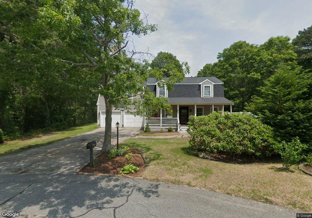
5 Camelot Ln Bourne, MA 2532
Estimated Value: $700,000 - $717,054
3
Beds
3
Baths
2,504
Sq Ft
$284/Sq Ft
Est. Value
About This Home
This home is located at 5 Camelot Ln, Bourne, MA 2532 and is currently estimated at $710,014, approximately $283 per square foot. 5 Camelot Ln is a home located in Barnstable County with nearby schools including Bourne High School, Bridgeview Montessori School, and New Testament Christian School.
Ownership History
Date
Name
Owned For
Owner Type
Purchase Details
Closed on
May 19, 2020
Sold by
Dimler Robert D
Bought by
Eisan David B and Eisan Jessica L
Current Estimated Value
Purchase Details
Closed on
Dec 12, 2018
Sold by
Spillane Thomas
Bought by
Hanoian David and Oliveria Joann D
Home Financials for this Owner
Home Financials are based on the most recent Mortgage that was taken out on this home.
Original Mortgage
$312,000
Interest Rate
4.9%
Mortgage Type
New Conventional
Purchase Details
Closed on
Sep 12, 2016
Sold by
Conway Russell and Conway Kathleen R
Bought by
Spillane Thomas
Home Financials for this Owner
Home Financials are based on the most recent Mortgage that was taken out on this home.
Original Mortgage
$320,000
Interest Rate
3.48%
Mortgage Type
New Conventional
Purchase Details
Closed on
Oct 8, 1996
Sold by
Weldon Park Rt and Mitchell
Bought by
Conway Russell and Whitney Susan
Create a Home Valuation Report for This Property
The Home Valuation Report is an in-depth analysis detailing your home's value as well as a comparison with similar homes in the area
Purchase History
| Date | Buyer | Sale Price | Title Company |
|---|---|---|---|
| Eisan David B | $416,000 | None Available | |
| Eisan David B | $416,000 | None Available | |
| Hanoian David | $390,000 | -- | |
| Hanoian David | $390,000 | -- | |
| Spillane Thomas | $400,000 | -- | |
| Spillane Thomas J | $400,000 | -- | |
| Conway Russell | $113,185 | -- | |
| Conway Russell W | $113,185 | -- |
Source: Public Records
Mortgage History
| Date | Status | Borrower | Loan Amount |
|---|---|---|---|
| Previous Owner | Hanoian David | $312,000 | |
| Previous Owner | Spillane Thomas J | $320,000 | |
| Previous Owner | Conway Russell W | $308,800 |
Source: Public Records
Tax History
| Year | Tax Paid | Tax Assessment Tax Assessment Total Assessment is a certain percentage of the fair market value that is determined by local assessors to be the total taxable value of land and additions on the property. | Land | Improvement |
|---|---|---|---|---|
| 2025 | $5,081 | $650,600 | $168,200 | $482,400 |
| 2024 | $4,969 | $619,600 | $160,200 | $459,400 |
| 2023 | $5,011 | $568,800 | $157,500 | $411,300 |
| 2022 | $4,738 | $469,600 | $139,400 | $330,200 |
| 2021 | $4,605 | $427,600 | $126,800 | $300,800 |
| 2020 | $4,505 | $419,500 | $125,600 | $293,900 |
| 2019 | $4,268 | $406,100 | $125,600 | $280,500 |
| 2018 | $4,090 | $388,000 | $119,700 | $268,300 |
| 2017 | $4,041 | $392,300 | $118,500 | $273,800 |
| 2016 | $3,625 | $356,800 | $118,500 | $238,300 |
| 2015 | $3,593 | $356,800 | $118,500 | $238,300 |
Source: Public Records
Map
Nearby Homes
- 3 Dover Ln
- 0 State Rd
- 16 Ocean Pines Dr Unit B
- 17 Andrew Rd
- 8 Driftwood Ln
- 17 Ridgehill Ln
- 11 Village Green Dr Unit B
- 10 Tecumseh Rd
- 4 Carmela Ln
- 150 Herring Pond Rd
- 11 Oak Bluff Rd
- 29 Eagle Hill Dr
- 64 Hunters Brook Rd
- 133 Phillips Rd
- 56 Samoset Rd
- 6 Aspen Rd
- 6 Aspen Rd
- 38 Siasconset Dr
- 67 Phillips Rd
- 67 Phillips Rd
Your Personal Tour Guide
Ask me questions while you tour the home.