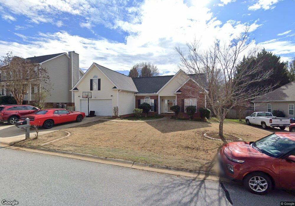
5 Caney Ct Simpsonville, SC 29680
Estimated Value: $344,000 - $364,000
4
Beds
3
Baths
2,563
Sq Ft
$139/Sq Ft
Est. Value
About This Home
This home is located at 5 Caney Ct, Simpsonville, SC 29680 and is currently estimated at $355,104, approximately $138 per square foot. 5 Caney Ct is a home located in Greenville County with nearby schools including Bryson Elementary School, Ralph Chandler Middle, and Woodmont High School.
Ownership History
Date
Name
Owned For
Owner Type
Purchase Details
Closed on
May 2, 2016
Sold by
Loftis Ricky L and Symons Teresa B
Bought by
Sykes Kenneth L and Sykes Terri
Current Estimated Value
Home Financials for this Owner
Home Financials are based on the most recent Mortgage that was taken out on this home.
Original Mortgage
$198,341
Outstanding Balance
$156,854
Interest Rate
3.87%
Mortgage Type
FHA
Estimated Equity
$198,250
Purchase Details
Closed on
Jun 17, 2003
Sold by
Symons Teresa B
Bought by
Loftis Teresa S
Purchase Details
Closed on
Apr 30, 1999
Sold by
Lazarus Shouse Communities
Bought by
Symons Teresa B
Create a Home Valuation Report for This Property
The Home Valuation Report is an in-depth analysis detailing your home's value as well as a comparison with similar homes in the area
Home Values in the Area
Average Home Value in this Area
Purchase History
| Date | Buyer | Sale Price | Title Company |
|---|---|---|---|
| Sykes Kenneth L | $202,000 | None Available | |
| Loftis Teresa S | -- | -- | |
| Symons Teresa B | $133,900 | -- |
Source: Public Records
Mortgage History
| Date | Status | Borrower | Loan Amount |
|---|---|---|---|
| Open | Sykes Kenneth L | $198,341 |
Source: Public Records
Tax History
| Year | Tax Paid | Tax Assessment Tax Assessment Total Assessment is a certain percentage of the fair market value that is determined by local assessors to be the total taxable value of land and additions on the property. | Land | Improvement |
|---|---|---|---|---|
| 2025 | $1,422 | $9,610 | $2,110 | $7,500 |
| 2024 | $1,422 | $8,360 | $1,400 | $6,960 |
| 2023 | $1,379 | $8,360 | $1,400 | $6,960 |
| 2022 | $1,345 | $8,360 | $1,400 | $6,960 |
| 2021 | $1,323 | $8,360 | $1,400 | $6,960 |
| 2020 | $1,307 | $7,760 | $1,120 | $6,640 |
| 2019 | $1,269 | $7,760 | $1,120 | $6,640 |
| 2018 | $1,357 | $7,760 | $1,120 | $6,640 |
| 2017 | $1,358 | $7,760 | $1,120 | $6,640 |
| 2016 | $3,526 | $194,010 | $28,000 | $166,010 |
| 2015 | $3,516 | $194,010 | $28,000 | $166,010 |
| 2014 | $3,185 | $177,866 | $22,555 | $155,311 |
Source: Public Records
Map
Nearby Homes
- 208 Terrapin Cross Way
- 1 Catbriar Ct
- 109 Salthouse Rd
- 19 Heydon Hall Ct
- 14 Foxmoor Ct
- 38 Leafmore Ct
- 4 Headwater Ct
- 414 River Trace Loop
- 1 Foxmoor Ct
- 318 River Trace Loop
- 406 Windwood St
- 617 Columbus Cir
- 14 Leafmore Ct
- 503 River Trace Loop
- 5 Brentmoor Place
- 134 Winding Rock Rd
- 601 Columbus Cir
- 5 Indian Laurel Ct
- 620 Columbus Cir
- 503 Plamondon Dr
Your Personal Tour Guide
Ask me questions while you tour the home.